
Isaias Remnants Deliver 1-3 Inches of Rain to DC, PA, and Carolinas
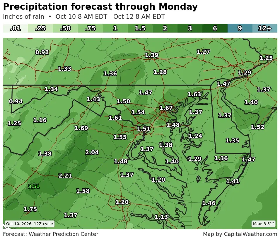
Hurricane Isaias made landfall in Florida as a Category 2 storm on Friday night, October 9, 2026, with winds reaching 103-105 mph. It has since transitioned into a post-tropical system moving north and east. The DC area expects 1-3 inches of rain from Saturday night to Monday morning, with a low but increased risk of isolated tornadoes. Pennsylvania and the Carolinas face similar heavy rain and flooding concerns, though widespread flooding is unlikely due to dry soils.
Key points
- Isaias made landfall near Destin, Florida, on Friday night as a Category 2 hurricane with winds of 103-105 mph.
- The storm has transitioned to a post-tropical system and is moving north and east, bringing rain to the eastern US through the weekend.
- DC area expects 1-3 inches of rain, with the most reliable models suggesting 1.5 inches in the immediate area, starting Saturday night and ending Monday morning.
- There is a low but increased risk of severe thunderstorms and isolated tornadoes in the DC area, particularly south and southeast of the city.
- Pennsylvania expects 1-2 inches of rain with gusty winds up to 55 mph in the Laurel Highlands, while the Carolinas face flash flooding concerns, especially in western North Carolina.
Background
Isaias is the first hurricane of the 2026 Atlantic season, having formed in the Gulf of Mexico on October 7, 2026. Florida Governor DeSantis declared a state of emergency for 25 counties in anticipation of its impact. This event follows earlier tropical systems like Dolly and Polo, which also brought significant rain and flooding risks to various parts of the US in 2026.
How outlets are covering it
Capital Weather emphasizes the rain timeline and tornado risk for the DC area, noting a slight increase in rainfall forecasts and a Level 1-2 risk for severe storms. WYFF focuses on flooding concerns in the Carolinas, particularly in western North Carolina, where flash flooding is the biggest threat. WTAE highlights the impact on Pennsylvania, noting that while rain is heavy, the dry ground mitigates widespread flooding, and wind gusts are a significant concern in the Laurel Highlands. All sources agree on the storm's path and the potential for heavy rain, but they differ in their emphasis on local risks such as tornadoes, flooding, and wind.
Why it matters
The remnants of Isaias pose a significant threat of heavy rain and potential severe weather to a large portion of the eastern United States. While widespread flooding is unlikely due to dry soils, isolated flooding and tornadoes are possible, requiring residents to stay alert and prepared. The event also highlights the ongoing impact of the 2026 Atlantic hurricane season, which has already seen multiple tropical systems affecting the US.
What to watch
Monitor weather updates for any changes in the rain timeline or severe storm risk. Residents in the DC area, Pennsylvania, and the Carolinas should be prepared for heavy rain and potential flooding, especially in poor-drainage areas. Keep an eye on wind conditions, particularly in the Laurel Highlands, where gusts up to 55 mph are expected. Stay informed through local weather services and emergency management updates.
- Isaias's remnants approach DC: More rain expected, with some severe storm risk Capital Weather
- Holiday weekend forecast: Isaias remnants to bring wet weather to New England on Sunday The Boston Globe
- Post-Tropical Isaias brings flooding concerns to the Carolinas WYFF
- Tracking cloudy skies on Saturday in central Indiana; hurricane remnants bring showers tonight Fox 59
- Western Pennsylvania braces for Hurricane Isaias remnants; heavy rain possible Sunday WTAE
Want the full story? Read the original reporting
Read on Capital Weather