
Isaias Remnants Leave Maryland Soaked Before Warm Front Arrives
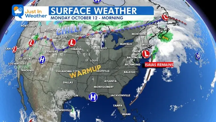
The remnants of Hurricane Isaias have moved off the Maryland coast, bringing significant rainfall and gusty winds before a brief warm spell. Justin Berk reports that Central Maryland received 3 to 4 inches of rain, while WBAL-TV notes widespread precipitation of 1 to 1.5 inches across the state. The low-pressure system is expected to clear by Monday afternoon, followed by temperatures rising into the 80s. A dramatic cold front is forecast to arrive next weekend, potentially bringing the first frost to Central Maryland.
Key points
- Hurricane Isaias made landfall in Florida on Friday night as a Category 2 storm before weakening into a low-pressure system.
- Maryland experienced its fifth consecutive 'Soggy Sunday,' with rain totals exceeding initial radar estimates in some areas.
- Central Maryland recorded 3 to 4 inches of rain, while most of the state received 1 to 1.5 inches according to WBAL-TV.
- Gusty winds up to 30 mph were reported, with a small chance of tornadoes in the D.C. area on Sunday evening.
- Temperatures are expected to warm into the 80s by Wednesday before a sharp drop next weekend.
- The upcoming cold front may bring the first frost to parts of Central Maryland by Sunday.
Background
Hurricane Isaias initially made landfall near Destin, Florida, on Friday night with sustained winds of 105 mph. It weakened significantly as it moved northward, losing tropical characteristics by Saturday morning. The storm's remnants continued to affect the Mid-Atlantic region, causing heavy rain and wind. This event follows a period of significant rainfall deficits in the region, with Baltimore having a cumulative rainfall deficit of 21.38 inches since 2024.
How outlets are covering it
Justin Berk of Just In Weather emphasizes the exceptional nature of the rainfall, noting that radar estimates underestimated the actual totals, with some spots in Central Maryland receiving 3 to 4 inches. He highlights the transition to warmer weather and the subsequent dramatic cold front. WBAL-TV focuses on the severe weather risks, including a Level 1 risk for severe storms and a small chance of tornadoes in the D.C. area. They also detail the impact on Annapolis, where officials prepared for potential flooding and wind. WMTW, covering Maine, notes that the remnants brought showers to coastal areas on Sunday and Monday, with temperatures dropping on Tuesday as low pressure arrived. The outlets differ in their focus: Berk on rainfall totals and temperature trends, WBAL-TV on severe weather risks and local impacts, and WMTW on the broader regional impact in Maine.
Why it matters
The remnants of Hurricane Isaias caused significant rainfall and wind in Maryland, leading to potential flooding and severe weather risks. The subsequent warm spell followed by a dramatic cold front highlights the volatility of the current weather pattern. The first frost of the season may arrive in Central Maryland, impacting agriculture and outdoor activities. The event also underscores the importance of preparedness for severe weather, as seen in Annapolis where officials monitored potential flooding and wind impacts.
What to watch
Maryland is expected to experience a brief warm spell with temperatures reaching the 80s by Wednesday. A cold front is forecast to arrive next weekend, bringing a dramatic temperature drop and potentially the first frost to Central Maryland. Rainfall is expected to taper off after Monday, with scattered showers possible on Thursday and Friday. The region will need to monitor for any further severe weather risks associated with the low-pressure system.
- October 12 Isaias Moves Away Followed By A Few Warm Days Just In Weather
- Isaias fades into the East Coast, threatening millions with flooding, widespread rain and severe storms FOX Weather
- Heavy rain and slight tornado risk, particularly south of Baltimore WBAL-TV
- Cloudy with showers on the way WMTW
- After several inches of rain from Isaias, skies will partially clear today with a mild breeze on tap ABC27
Want the full story? Read the original reporting
Read on Just In Weather