
Nor'easter Sends 12-Foot Waves Over Maine Roads, Draws Surfers
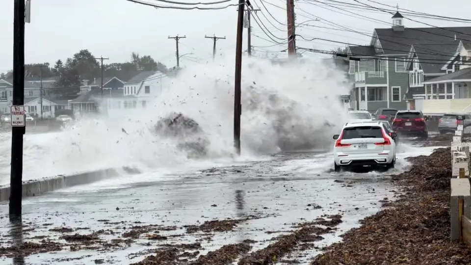
A powerful nor'easter battered Maine's coast on Sunday, September 27, 2026, generating 7- to 12-foot waves that overtopped seawalls and flooded roads. The storm caused localized flooding, power outages, and property damage, while simultaneously attracting large crowds of surfers to coastal beaches.
Key points
- Waves reached 7 to 12 feet, crashing over seawalls in Wells and flooding roads with debris and sea foam.
- A flood advisory remains in effect for the Maine coast until early Monday morning, following the next high tide.
- Central Maine Power restored service to tens of thousands of customers after weekend outages caused by the storm.
- Saco Public Works temporarily closed the intersection of Main and North Avenues near Camp Ellis due to safety concerns.
- Dozens of surfers gathered at Gooch's Beach and Higgins Beach in Kennebunk to ride the storm-generated waves.
Background
This event follows a series of severe weather and accident incidents in the region over the past two months, including a fatal plane crash in Bristol in August and various power line-related aviation incidents. The current nor'easter represents a significant meteorological event distinct from those prior accidents, focusing on coastal infrastructure and public safety rather than aviation or traffic collisions.
How outlets are covering it
WMTW emphasized the destructive potential of the storm, highlighting waves swamping vehicles, tossing rocks, and creating hazardous driving conditions, while noting that southern New England experienced even more intense conditions. The Portland Press Herald offered a contrasting view, focusing on the recreational aspect of the storm, describing how dozens of surfers flocked to beaches like Gooch's and Higgins to take advantage of the large waves, viewing the nor'easter as ideal weather for surfing rather than a hazard. WGME confirmed the ongoing impacts, noting that rain, wind, and high surf would continue into Tuesday morning before dry, warm conditions returned midweek.
Why it matters
The nor'easter demonstrated the vulnerability of coastal infrastructure in Maine, causing road closures, power outages, and property damage. It highlighted the dual nature of such storms, posing significant risks to public safety and property while simultaneously providing opportunities for recreational activities like surfing. The event underscores the need for preparedness and caution during high surf events, as well as the importance of timely power restoration and public safety measures.
What to watch
A flood advisory is expected to remain in effect until early Monday morning, following the next high tide. Dry conditions and warmer temperatures are forecast to return to the area by midweek. Authorities will likely monitor for any residual flooding or damage as the storm system moves away.
- Watch: Large waves crash along Maine coast, swamp vehicles, as nor'easter passes WMTW
- Nor’easter weakens, but Maine stays rainy and cool WMTW
- Nor'easter continues to bring impacts to Maine with rain, wind and high surf WGME
- Nor'easter forces road closures in Saco newscentermaine.com
- For surfers, a nor’easter in Maine means perfect weather The Portland Press Herald
Want the full story? Read the original reporting
Read on WMTW