
Northeast faces wind, rain, and first frost as storm system weakens
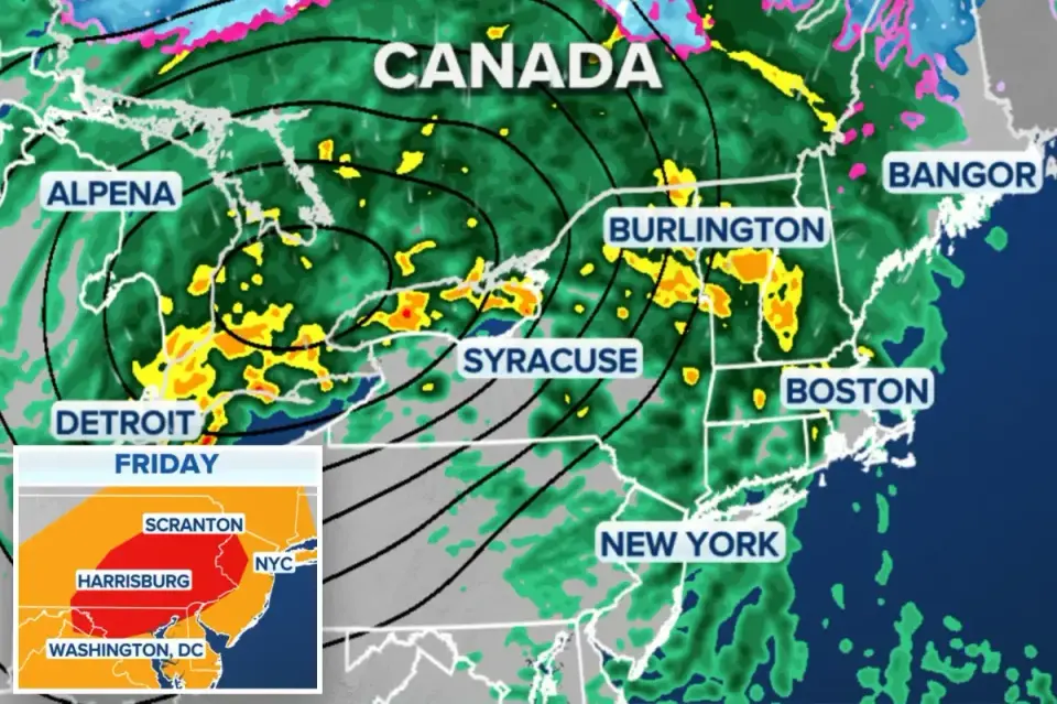
A powerful storm system is moving through the Great Lakes on Thursday before reaching the Northeast on Friday, bringing rain, strong winds, and the season's first significant cold snap. While the system was initially expected to 'bomb out' off the New England coast, forecasters now indicate it will not meet the technical definition of bombogenesis, though damaging wind gusts of 30-50 mph remain likely. The storm will be followed by a sharp temperature drop, with the coldest air of the season arriving over the weekend, potentially bringing the first frost and snow to higher elevations.
Key points
- Storm moves through Great Lakes Thursday, reaching Northeast Friday morning.
- Wind gusts of 30-50 mph expected in New England, with peaks near Nova Scotia and Newfoundland.
- Rainfall generally under an inch, but heavier downpours possible north of Interstate 90.
- Severe thunderstorm risk in Mid-Atlantic and New York's Catskills/Hudson Valley, with possible tornadoes.
- Coldest air of season follows storm, with lows in upper 20s to low 30s in interior valleys.
- First frost and 1-3 inches of snow possible in Adirondacks, Green Mountains, and White Mountains by Saturday night.
Background
This storm follows a series of significant weather events in the Northeast this fall, including a nor'easter in late September that caused power outages, travel disruptions, and record rainfall across New England. The current system marks the first major fall freeze, signaling a transition to colder temperatures after a record-setting heat wave earlier in the week.
How outlets are covering it
FOX Weather and the New York Post emphasize the storm's potential for dangerous wind gusts and the transition to cold temperatures, noting that while the system won't officially 'bomb out,' it will still bring significant impacts. NBC Boston and CBS News focus on the local impacts in the Boston area, highlighting the risk of downpours, thunderstorms, and the sharp temperature drop leading to widespread frost. NBC Boston notes that the storm is 'a big weather maker' despite not being 'big on rain,' while CBS News warns of the risk of severe weather, particularly strong winds within thunderstorms. All sources agree on the timing and general impact of the storm but differ in their emphasis on the severity of the wind and the potential for severe thunderstorms.
Why it matters
The storm and subsequent cold snap will impact travel, commuting, and outdoor activities across the Northeast. The risk of severe thunderstorms, damaging winds, and the first frost of the season could lead to power outages, travel disruptions, and agricultural losses. The sharp temperature drop also signals the end of the record-setting heat wave and the beginning of colder fall weather.
What to watch
The storm is expected to wind down late Friday, with the coldest air of the season arriving over the weekend. Temperatures are expected to recover slightly by Monday, but the region will remain in a cooler pattern. Forecasters are monitoring a potential storm developing off the Mid-Atlantic coast, but guidance is currently uncertain.
- Powerful storm to slam the Northeast with rain, dangerous winds before first major fall freeze New York Post
- Rain, wind and cold temps: What to expect in Boston's forecast NBC Boston
- Our next system arrives Friday for a soggy and breezy Boston. Maps show how much rain we can expect. The Boston Globe
- Risk of downpours, thunderstorms in forecast for Boston area Friday, widespread frost this weekend CBS News
- Mass. futurecast: Heavy rain, 45 mph gusts usher in the coldest weekend of the season Yahoo
Want the full story? Read the original reporting
Read on New York Post