
Scientists Link Nepal's Deadly Flood to Climate-Driven Cascade of Failures
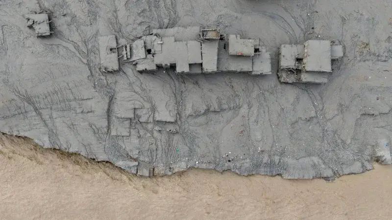
A team of over 20 international scientists concluded that the August 2026 flood in Nepal was not caused by a single event, but by a complex cascade of factors intensified by human-driven climate change. The disaster, which killed at least 1,300 people and left over 5,000 missing, began when a massive chunk of rock and ice from Langtang Lirung mountain collapsed. This avalanche released energy equivalent to a magnitude 5.2 earthquake, melting ice instantly and triggering a flood wave that traveled over 20 miles downstream. The analysis highlights how rising temperatures, thawing permafrost, and glacier thinning weakened the mountain's stability, making such an unprecedented event possible.
Key points
- The August 26, 2026, disaster involved a rock and ice avalanche approximately 2,000 feet wide that fell 7,000 feet into a river, releasing energy comparable to a magnitude 5.2 earthquake.
- The resulting flood wave traveled more than 20 miles downstream, destroying towns, roads, and bridges, and killing at least 1,300 people while leaving over 5,000 missing.
- Scientists from World Weather Attribution found that the collapse was triggered by a cascade of processes, including a 2015 earthquake that weakened the slope, increased landslide rates, and significant glacier thinning since 2010.
- Climate change has raised the 'zero degree' line in the Himalayas by over 320 feet per decade, weakening permafrost that acts as a binding agent for rock and soil.
- Regional temperatures in July and August were approximately 1.5 degrees Celsius warmer than historical averages due to climate change, while annual temperatures have risen by 2 degrees Celsius, significantly above the global average.
- Record snowfall in the previous autumn followed by record-warm summer months likely created large amounts of meltwater, further destabilizing the slope.
Background
This analysis follows earlier reports confirming that the August 2026 flood was triggered by a glacial collapse near Langtang Lirung, not an earthquake, as confirmed by the USGS. Previous coverage noted that the flood surge rose 7-9 meters in about 30 minutes, overwhelming monitoring stations. Rescue operations, including the use of drones and rafts in tunnels, continued for weeks as the death toll climbed. The current report provides a deeper scientific explanation for why the collapse occurred, linking it to long-term climate trends and historical seismic events.
Why it matters
The findings underscore the increasing vulnerability of the Himalayas to extreme events driven by climate change. The inability of existing warning systems to predict such a complex, multi-factor disaster highlights the urgent need for new adaptation strategies and rapid reductions in fossil fuel emissions to prevent similar catastrophic events in the future.
What to watch
Nepal is transitioning from rescue to recovery and rebuilding efforts. The scientific community will likely continue to monitor the region for further instability, and policymakers may face increased pressure to implement climate mitigation and adaptation measures in vulnerable mountain regions.
Want the full story? Read the original reporting
Read on CNN