
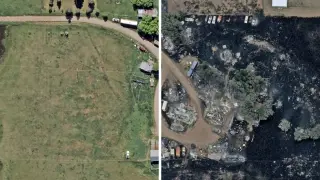
Aerial analysis suggests Aspen Acres fire destroyed 780 structures, outpacing official tallies
A private aerial-imagery firm estimated that the Aspen Acres wildfire destroyed about 780 structures across Pueblo and Custer counties—well above the 192 homes and four commercial buildings confirmed by officials. The blaze has burned more than 96,000 acres and ranks as Colorado’s seventh-largest on record. The analysis, using high-resolution fixed-wing imagery and AI, excludes buildings built after Sept. 1, 2024 and may miss damage in smoke-obscured areas; officials say damage tallies currently focus on homes, with other structures potentially still being counted.