
DC Region Braces for Sudden Cold Front, Wind Gusts, and Frost Risk
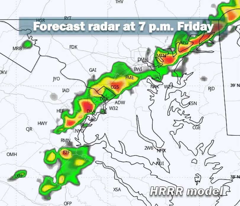
A severe thunderstorm watch is in effect for the DC region until 8 p.m. Friday as a fast-moving cold front brings damaging wind gusts and a rapid temperature drop. The squall line is expected to arrive between 5 and 9 p.m., with peak gusts reaching 50 to 65 mph. Temperatures will plunge approximately 30 degrees within 12 hours, dropping from highs near 80 degrees to lows around 50 degrees by dawn Saturday. Saturday will be blustery with highs only in the mid-50s, and frost is possible Sunday morning west of Interstate 95.
Key points
- National Weather Service issued a severe thunderstorm watch for the DC region until 8 p.m. Friday.
- A squall line is expected to sweep through the area between 5 and 9 p.m., with storms lasting 30 minutes or less.
- Peak wind gusts could reach 50 to 65 mph, potentially causing tree damage and power outages.
- Temperatures will drop roughly 30 degrees in 12 hours, falling from near 80 degrees to around 50 degrees by dawn.
- Saturday will feature blustery conditions with highs only in the mid-50s, and frost is possible Sunday morning west of Interstate 95.
Background
This event follows a recent pattern of severe weather in the region, including a severe thunderstorm watch in September 2026 and a powerful storm system affecting the Northeast in October 2026. The current cold front marks a sharp transition from summerlike conditions to cooler, blustery weather, consistent with seasonal shifts observed in previous months.
How outlets are covering it
Capital Weather emphasizes the rapid temperature drop and wind gusts, noting the squall line will move quickly through the area. WBFF and WBAL-TV highlight the risk of isolated tornadoes and damaging winds, with WBAL-TV specifically mentioning the potential for tornadoes in Maryland. WTOP News focuses on the sharp temperature decline and the return of 'jacket weather,' noting that most severe activity will remain north of the DC metro area. All sources agree on the severe thunderstorm watch and the significant temperature drop, but differ in emphasis on tornado risk and the geographic distribution of the most intense storms.
Why it matters
The sudden shift in weather conditions poses risks to infrastructure, transportation, and public safety. Damaging wind gusts could cause power outages and tree damage, while the rapid temperature drop and potential frost could impact agriculture and outdoor activities. The blustery conditions on Saturday may also affect events such as the Baltimore Running Festival. Residents are advised to prepare for potential power outages, secure outdoor items, and monitor weather updates for any changes in the forecast.
What to watch
Residents should monitor weather updates for any changes in the forecast, particularly regarding tornado risk and wind gusts. Power outages may occur due to tree damage, and residents should report outages to their utility providers. Frost is possible Sunday morning west of Interstate 95, so residents in those areas should take precautions to protect plants and outdoor items. The blustery conditions on Saturday may affect outdoor events, so attendees should prepare for windy conditions.
- Severe thunderstorm watch: Friday evening storms could spawn strong winds, then temperatures tumble Capital Weather
- Severe Thunderstorm Watch In Effect Ahead of Strong Cold Front WBFF
- Weather Alert Day: Strong storms and wind, isolated tornado risk WBAL-TV
- Severe thunderstorms could develop in DC area Friday WTOP News
- Storm Team4 Forecast: Severe thunderstorm watch Friday and cooler temps this weekend NBC4 Washington
Want the full story? Read the original reporting
Read on Capital Weather