
Hurricane Isaias targets northern Gulf Coast with 7-foot surge threat
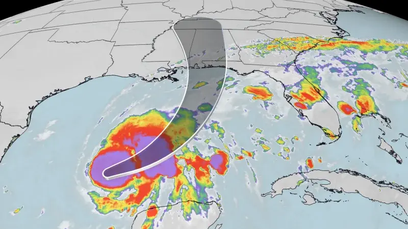
Hurricane Isaias, the 2026 Atlantic season's first hurricane, is forecast to make landfall on the northern Gulf Coast late Friday or early Saturday. The storm is expected to bring dangerous storm surge, heavy rainfall, and strong winds to Mississippi, Alabama, and the Florida Panhandle. State of emergency declarations and mandatory evacuations have been issued in response.
Key points
- Isaias reached Category 1 status with 75 mph winds late Wednesday, with potential to peak at Category 2 (110 mph) before landfall.
- A hurricane warning is in effect from Ocean Springs, Mississippi, to the Florida Bay-Gulf county line, with a storm surge warning extending to Yankeetown, Florida.
- Florida Governor Ron DeSantis declared a state of emergency for 25 counties, while Alabama Governor Kay Ivey declared a state of emergency for 40 counties.
- Mandatory evacuations were issued for coastal areas in Okaloosa County, Florida, and Dauphin Island, Alabama, with additional voluntary evacuations recommended for low-lying areas.
- Forecasters expect 3 to 10 inches of rain in the central Gulf Coast, with storm surge potentially reaching 7 feet in areas from eastern Mississippi to the western Florida Panhandle.
Background
Isaias is the ninth named storm of the 2026 Atlantic hurricane season, which ends November 30. The storm formed from Tropical Depression Nine and rapidly intensified, a trend attributed to warming oceans. Previous archive coverage noted the storm's rapid intensification and its bypass of Texas, focusing impacts on the northern Gulf Coast.
How outlets are covering it
CNN emphasizes the rapid intensification of Isaias and the potential for Category 2 strength before landfall, highlighting the risks of storm surge and flooding. CBS News focuses on the broader impacts, including rainfall extending to the Tennessee Valley and Carolinas, and notes the historical significance of 'I'-named storms. News4JAX provides specific details on the 25 Florida counties under state of emergency and the mobilization of emergency resources by the Florida State Emergency Response Team. All sources agree on the landfall timing and the severity of the storm's impacts, but differ in their emphasis on regional impacts and preparedness measures.
Why it matters
Hurricane Isaias poses a significant threat to the northern Gulf Coast, with potential for life-threatening storm surge, heavy rainfall, and strong winds. The storm's rapid intensification and the issuance of state of emergency declarations and mandatory evacuations underscore the severity of the situation. Residents in the affected areas are urged to prepare for potential impacts, including power outages, flooding, and tornadoes.
What to watch
Isaias is expected to make landfall late Friday or early Saturday, with peak impacts arriving at that time. The storm is forecast to weaken slightly before landfall but will still pose significant risks. Conditions are expected to improve over most of the South by Saturday night or Sunday as leftover rain moves toward the East Coast.
- Isaias: Gulf Coast faces hurricane threat as Tropical Depression Nine is forecast to strengthen CNN
- Tropical Depression Nine forms in the Atlantic on track to be first dangerous hurricane of the season FOX Weather
- Tropical Storm Isaias could form in the Gulf later this week The Weather Channel
- Baker, Columbia among 25 Florida counties under state of emergency as Tropical Depression Nine forms News4JAX
- Tropical threat brewing in Gulf could impact U.S. as a hurricane this weekend. See maps, possible path. CBS News
Want the full story? Read the original reporting
Read on CNN