
Tropical Storm Marie threatens Southern California with coastal flooding, not hurricane winds, for Labor Day
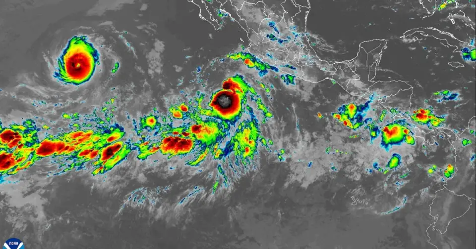
Tropical Storm Marie, developing south of Baja California, may bring coastal flooding and heavy rain to Southern California by Labor Day weekend, though it is expected to weaken significantly before reaching the coast. Forecasters warn of high uncertainty in the storm's path, with the most likely outcome being a decaying system that delivers moisture and dangerous surf rather than hurricane-force winds. The event highlights ongoing risks from record ocean temperatures and a developing El Niño, which could increase future tropical cyclone impacts on the region.
Key points
- Tropical Storm Marie is forecast to intensify into a hurricane by Wednesday but is expected to weaken below tropical storm status before reaching Southern California.
- The primary risk for the region is coastal flooding from large swells arriving Saturday and Sunday, coinciding with high tides, rather than wind damage.
- Forecasters indicate a low chance of widespread heavy rain but acknowledge a potential for flash floods and landslides if the storm tracks near the mountains.
- Ocean temperatures off Southern California remain too cool to sustain a hurricane, though record heat and a developing El Niño are increasing overall tropical activity.
- The National Weather Service describes the forecast as a 'low confidence period' with multiple possible outcomes, emphasizing the need for monitoring rather than panic.
Background
This event follows a pattern of increased tropical activity in the eastern Pacific linked to a developing El Niño. In 2023, Hurricane Hilary caused approximately $900 million in damage in the U.S. and significant flooding in California and Baja California. Historical records show that only two tropical storms have directly impacted California in the modern era: the 1939 storm 'El Cordonazo' and Tropical Storm Nora in 1997. A 2026 study in Nature Climate Change suggests that the risk of tropical cyclone-induced rainfall and landslides in Southern California will increase rapidly through 2050 due to climate change and population growth.
How outlets are covering it
The Los Angeles Times and ABC7 Los Angeles emphasize the potential for coastal flooding and heavy rain, noting that while hurricane winds are unlikely, the storm could bring 'hefty showers' and dangerous surf. The Los Angeles Daily News and The Washington Post focus on the low probability of a direct hurricane impact, with NWS meteorologist Mike Wofford stating that cold water off the coast 'kills a lot of storms.' While all sources agree on the uncertainty of the track, the Daily News and Washington Post highlight the contrast between social media speculation and the scientific consensus that a direct hurricane hit is highly improbable. The Los Angeles Times provides additional context on the 2023 Hilary event and historical storms to illustrate the potential severity of such events, whereas the other outlets focus more on the immediate, lower-impact forecast for the weekend.
Why it matters
The potential for coastal flooding and heavy rain during Labor Day weekend poses a direct risk to residents and tourists in Southern California. The event underscores the increasing influence of climate change on weather patterns, with record ocean temperatures and El Niño conditions creating a higher likelihood of tropical systems affecting the region. Understanding the difference between hurricane-force winds and tropical storm impacts is crucial for public safety, as the primary threats are flooding and rip currents rather than structural wind damage. This event also serves as a preview of the potential impacts of a 'super-El Niño' expected later in the year, which could bring more destructive storms and erosion to the coast.
What to watch
Forecasters will continue to monitor Tropical Storm Marie's path over the next few days, with the most likely scenario being a westward veer away from the coast. If the storm tracks north, it is expected to weaken to a tropical depression or below before reaching Southern California. Residents should monitor updates from the National Weather Service for changes in the forecast, particularly regarding surf conditions and potential rainfall. The focus will shift to preparing for coastal flooding and rip currents rather than hurricane preparedness, with officials advising caution near the coast during high tides on Saturday and Sunday.
- Could a hurricane send floods to Southern California for Labor Day weekend? Los Angeles Times
- Tropical Storm Marie could bring rain, wind, high surf to SoCal over Labor Day weekend ABC7 Los Angeles
- Pacific hurricane could impact Southern California Labor Day weekend KTLA
- Is a hurricane coming to Southern California this weekend? Experts say it’s unlikely Los Angeles Daily News
- No, a hurricane is not expected to hit California next week washingtonpost.com
Want the full story? Read the original reporting
Read on Los Angeles Times