
Stalled Front and Isaias Bring Prolonged Flooding Risk to Florida
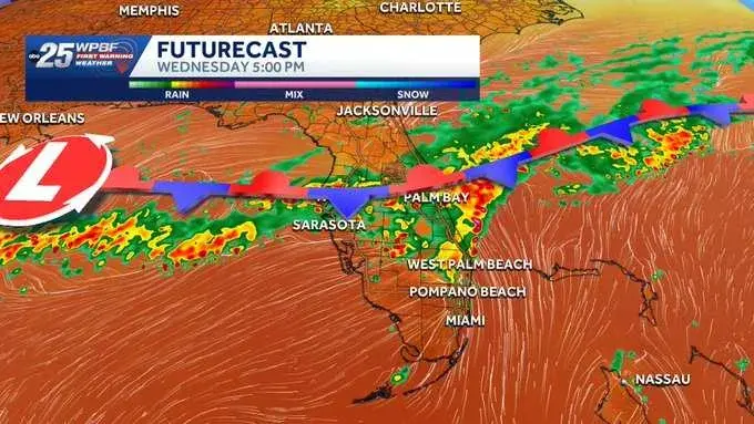
A stalled cold front is keeping South and Central Florida wet through the weekend, with a marginal risk of excessive rainfall and localized flooding. Tropical Storm Isaias has intensified into the first hurricane of the 2026 Atlantic season and is forecast to threaten the state as a Category 2 system. While the front lingers, daily rain chances remain high, with some areas potentially receiving several inches of precipitation. Conditions are expected to dry out early next week.
Key points
- A stalled front remains just north of South Florida, keeping scattered showers and thunderstorms in the forecast through the weekend.
- Tropical Storm Isaias has become the first hurricane of the 2026 Atlantic season and is forecast to threaten Florida as a Category 2 hurricane.
- Central Florida faces a marginal risk of excessive rainfall, with some areas potentially receiving 3 to 5 inches of rain through Thursday.
- Boating conditions are expected to become hazardous north of Cape Canaveral, and beach conditions may deteriorate along Volusia and Brevard counties.
- The wet pattern is expected to gradually dry out by Monday and Tuesday of the following week.
Background
This event follows a series of significant weather events in Florida, including record-breaking king tides in late September that submerged streets in South Florida and Tropical Storm Nolo's threat to Hawaii in September. The current stalled front and Isaias add to the region's ongoing challenges with heavy rainfall and flooding risks.
How outlets are covering it
WPBF emphasizes the stalled front's impact on South Florida, noting a marginal risk of excessive rainfall and localized flooding, especially along the Treasure Coast. The Orlando Sentinel highlights the stalled cold front's effect on Central Florida, with rain chances of 80-90% and a marginal risk of excessive rainfall through Thursday. WKMG and WFTV both focus on the prolonged wet weather in Central Florida, with WKMG noting potential rainfall of 3-5 inches and WFTV warning of localized flooding and ponding on roadways. All sources agree on the stalled front's role in maintaining the wet pattern, but they differ in their emphasis on specific regions and the potential impact of Isaias.
Why it matters
The stalled front and Isaias pose significant risks of flooding and hazardous conditions for residents and visitors in Florida. The prolonged wet weather could lead to localized flooding, reduced visibility, and standing water on roads, impacting daily life and infrastructure. The potential impact of Isaias as a Category 2 hurricane adds to the urgency for preparedness and monitoring of weather conditions.
What to watch
The stalled front is expected to linger through the weekend, keeping rain chances elevated. Conditions are forecast to gradually dry out by Monday and Tuesday of the following week. Residents should monitor weather updates and prepare for potential flooding and hazardous conditions, especially in low-lying areas and along the coast.
- Flooding possible as storms intensify across South Florida this week WPBF
- Stalled cold front means more heavy rain in store for Central Florida Orlando Sentinel
- Central Florida faces days of heavy rain, flooding risk through Thursday WKMG
- Wet week ahead for Central Florida as heavy rain could lead to flooding WFTV
- Rounds of showers expected in Central Florida; flood watch issued WESH
Want the full story? Read the original reporting
Read on WPBF