
Gulf low pressure system targets Texas coast for midweek rainfall
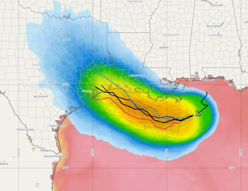
A tropical low pressure system, designated Invest 97L, has formed in the northern Gulf of Mexico. Forecasters expect it to move westward toward the upper Texas coast by Tuesday or Wednesday, potentially bringing 1 to 3 inches of rain to drought-stricken areas. While the system has a low chance of intensifying into a tropical storm, warm waters and low wind shear keep development possible. Southeast Louisiana faces a marginal flood risk, with showers expected through the week.
Key points
- Invest 97L is located approximately 100 miles south of the Mississippi River mouth and is moving west-northwest.
- The system is expected to reach land near the Galveston Bay to Texas-Louisiana border area by midweek.
- Rainfall estimates range from 1 to 3 inches, though exact totals remain uncertain due to the lack of a well-formed center.
- Surface waters are warm and wind shear is low, creating conditions that could support intensification, though the baseline forecast remains a tropical low or depression.
- Southeast Louisiana and south Mississippi face a level 1 marginal risk of flooding, with high temperatures in the low 90s.
Background
This development follows Tropical Storm Bertha, which impacted the Gulf Coast in late July 2026. Bertha brought heavy rain and minor coastal flooding to Louisiana and the Texas border region before weakening and moving inland. The current system, Invest 97L, is distinct from Bertha but occurs in a region that has recently experienced tropical activity.
How outlets are covering it
Space City Weather emphasizes the potential for beneficial rainfall in the Houston region, noting that the system could alleviate drought conditions if it tracks correctly. However, they caution that the rain might fall further east, near Beaumont or southwestern Louisiana, leaving western Texas areas dry. WDSU focuses on the immediate impact for southeast Louisiana, highlighting a marginal flood risk and increased moisture for the coming days. WBRZ notes a low chance of development for the system, referred to as AL97, and mentions that remnants of Tropical Storm Dolly may add additional moisture to the Gulf region. While Space City Weather highlights the risk of rapid intensification similar to Hurricane Alicia, WBRZ maintains that the probability of significant development is low.
Why it matters
The potential for 1 to 3 inches of rain is significant for drought-stricken parts of Texas, which have been seeking relief. However, the uncertainty in the track means that some areas may receive little to no rain, while others could face localized heavy rainfall and flooding. The warm Gulf waters and low wind shear present a risk for rapid intensification, which could alter the forecast trajectory and impact severity. Residents in the upper Texas coast and southeast Louisiana should monitor updates for potential changes in the system's strength and path.
What to watch
Forecasters will continue to monitor the system's organization and track over the next 48 hours. If the system develops a well-defined center, it could strengthen into a tropical storm. The exact timing and coverage of rainfall will depend on the movement of the low pressure system and other disturbances in the Gulf. Updates are expected as the system approaches landfall on Tuesday or Wednesday.
- What does the tropical blob in the Gulf mean for Texas? Space City Weather
- Gulf disturbance becomes better organized, now has 50% chance of developing near Louisiana WWLTV.com
- Gulf disturbance increases rain chances, Could develop into a tropical system KLFY.com
- A Gulf disturbance will increase rain chances for southeast Louisiana WDSU
- Sunday AM forecast: Signals show a wetter pattern ahead WBRZ
Want the full story? Read the original reporting
Read on Space City Weather