
Hurricane Polo Regains Cat 5 Status, Targets Baja California and U.S. Desert
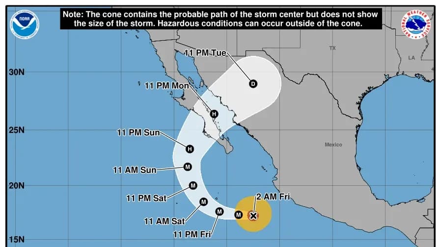
Hurricane Polo has regained Category 5 strength with 180 mph winds and is moving away from Mexico's western coast. It is forecast to turn north, making landfall in Baja California Sur on Monday before weakening into a post-tropical depression. The storm's remnants are expected to bring significant rainfall to New Mexico, Texas, and parts of the Midwest by the end of September.
Key points
- Polo is currently 320 miles southwest of Cabo Corrientes, Mexico, with maximum sustained winds of 180 mph.
- The storm is moving west at 10 mph but is forecast to turn north on Sunday, heading toward Baja California Sur.
- Landfall in Baja California Sur is expected on Monday, potentially rivaling the strongest storms on record for that region.
- Remnants of Polo are expected to bring heavy rain to New Mexico, Texas, Oklahoma, and Kansas by September 30.
- The National Weather Service has extended warnings for excessive rainfall in the southwestern U.S. due to Polo's moisture interacting with other systems.
Background
Polo intensified to Category 5 status earlier this week, becoming the second-strongest hurricane in Eastern Pacific history. It was fueled by record-breaking El Niño waters, which have also prompted emergency declarations in California due to coastal flooding risks from previous storms like Marie.
How outlets are covering it
USA TODAY emphasizes the immediate threat of Polo's remnants to the U.S. Southwest, highlighting concerns from the National Weather Service about excessive rainfall in New Mexico and Texas. Yale Climate Connections provides a broader context, noting that Polo is part of an unusually active Pacific season, with multiple hurricanes including Nolo threatening Hawaii. ABC7 Los Angeles focuses on the local impact in Long Beach, where officials are preparing for coastal flooding and high surf, linking the storm's effects to the ongoing El Niño pattern and previous damage from Hurricane Marie.
Why it matters
Polo's trajectory poses significant risks of flooding and mudslides in Mexico and the southwestern U.S. The storm's interaction with other weather systems could lead to widespread rainfall, impacting infrastructure and communities in regions already recovering from previous storm damage.
What to watch
Forecasters expect Polo to weaken after making landfall in Baja California Sur on Monday. Its remnants will continue to move across northern Mexico, with heavy rain expected in the U.S. Southwest by the end of September. The National Hurricane Center will monitor the storm's intensity fluctuations and track its path for potential impacts on the U.S. mainland.
- Track path of eye-popping Category 5 Hurricane Polo as it strengthens USA Today
- Hurricane Polo is a Category 4 monster, a 'rare show of force' USA Today
- Pacific’s cyclone factory is working overtime as multiple hurricanes roar across the basin Yale Climate Connections
- Long Beach ramps up storm preps as Hurricane Polo threatens more damage, raises coastal flooding concerns ABC7 Los Angeles
- Monster Cat 5 Hurricane Polo restrengthens, will slam Mexico and fuel renewed Southwest flood threat next week FOX Weather
Want the full story? Read the original reporting
Read on USA Today