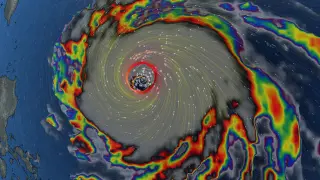
Super Typhoon Champi has become the strongest tropical cyclone of 2026 by wind speed, reaching 296 km/h. It is now the seventh Category 5 storm of the year. The storm is tracking west toward Taiwan, where a sea warning is expected, while its influence is already altering weather patterns in Canada.
Recent storms have resulted in five fatalities in Mexico, while the risk of severe flooding in the United States has decreased. This follows the dissipation of Hurricane Polo, which previously caused significant flash flood emergencies in the southwestern U.S. and heavy rainfall in northern Mexico.
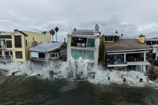
A second wave of historic rainfall in Nebraska, following the remnants of Hurricane Polo, triggered severe flooding in Omaha and Lincoln on October 2. Omaha experienced over 80 water rescues in three hours, with water depths reaching 8 feet in some areas. Lincoln recorded new all-time high water levels for its creeks. The event caused significant infrastructure damage, including road closures, power outages, and extensive property loss for residents.
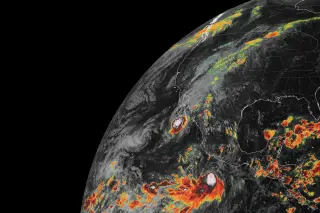
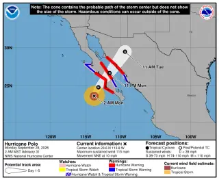
Hurricane Polo made landfall in Mexico's Baja California Sur as a Category 3 storm, bringing life-threatening winds and flash floods. Its remnants have since moved into the United States, merging with other weather systems to create a 'hybrid storm' that poses significant flooding risks across the Southwest and central US through mid-week.
A slow-moving frontal boundary is interacting with moisture from former Hurricane Polo, Hurricane Rachel, and the Gulf of Mexico, causing repeated 'training' thunderstorms and record-breaking rainfall across the Central Plains. Lincoln, Nebraska, recorded its wettest day in 139 years, while flash flood warnings remain active from Texas to the Midwest.
Remnants of Hurricane Polo caused historic flooding across Nebraska on September 30, 2026. Omaha experienced a 100-year flood event with water depths reaching 8 feet, leading to dozens of rescues. Lincoln set an all-time daily rainfall record of 6.15 inches. Major road closures and power outages disrupted the region, though conditions are expected to improve as waters recede.
Remnants of Hurricane Polo caused historic flooding in southeastern Nebraska on September 30, 2026. Lincoln recorded 6.15 inches of rain, shattering its all-time daily record. Omaha reported 50 rescues and no fatalities, while Lancaster County evacuated assets from Salt Creek zones. Drier conditions are expected by Thursday.
Hurricane Polo, which briefly reached Category 5 status, has dissipated over Mexico but its remnants are now driving severe flooding across the southwestern United States. The storm made landfall in Baja California Sur on Monday and moved northeast into Sonora, bringing heavy rain to the U.S. border. As of Tuesday, more than 30 million people from Arizona to Iowa face flash flood risks. In southern New Mexico, the McLeod Dam in Doña Ana County is under critical stress, prompting evacuation orders and emergency pumping operations. The National Weather Service has issued flash flood watches spanning over 1,200 miles, with rainfall rates reaching 4 inches per hour in some areas. While the storm has weakened, its moisture is combining with other weather systems to create a significant threat through the week.
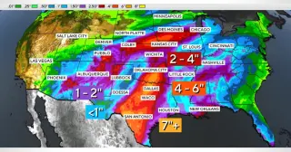
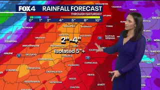
Remnants of Hurricane Polo are bringing a severe flash flood threat to Texas, prompting Governor Greg Abbott to activate over 1,900 state responders. Heavy rainfall of 2 to 7 inches is expected across the state, with the highest risks concentrated along the I-35 corridor and in North Texas. Officials urge residents to prepare for potential road closures and life-threatening water levels.
Hurricane Polo made landfall in Mexico’s Baja California Sur on Monday night, sending moisture-rich remnants into the United States. These remnants are merging with an upper-level trough to create a 'hybrid storm' that threatens life-threatening flash floods across the Southwest and Plains through Wednesday. Flood watches are currently in effect for approximately 28 million people, with the highest risks concentrated in Arizona, New Mexico, Colorado, Kansas, Oklahoma, and Texas.
Hurricane Polo made landfall in Mexico’s Baja California Sur on Monday night, sending moisture-rich remnants into the U.S. Southwest. These remnants are merging with an upper-level trough to create a 'hybrid storm' that threatens life-threatening flash floods across the Southwest and Plains through Wednesday. Flood watches are currently in effect for approximately 28 million people, with the highest risks concentrated in Arizona, New Mexico, Colorado, Kansas, Oklahoma, and Texas.
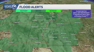
A statewide flood watch is in effect for New Mexico as remnants from Hurricane Polo and Tropical Storm Odalys bring heavy rain and flash flood risks through Tuesday. The National Weather Service warns of 1 to 4 inches of rainfall, with some areas potentially receiving up to 6 inches, exacerbating already saturated ground conditions from recent storms.
Category 3 Hurricane Polo made landfall in Baja California, Mexico, on Monday evening with 115 mph winds, bringing life-threatening flash floods and storm surges. While the storm weakened upon hitting land, its remnants combined with other weather systems to create a 'hybrid storm' that is causing widespread heavy rainfall and flooding risks across the southwestern and central United States through mid-week.
Hurricane Nolo has moved away from Hawaii but continues to threaten the Big Island with heavy rain and high winds, while Category 3 Hurricane Polo approaches the Baja California Peninsula in Mexico. Hawaii officials are managing the aftermath of a third consecutive hurricane this season, with federal emergency assistance authorized. Meanwhile, Mexican authorities are deploying naval vessels and military personnel to prepare for Polo's landfall, which is expected on Monday. The Pacific is experiencing an unusually active hurricane season, consistent with El Niño conditions.
The remnants of Hurricane Polo are moving inland from the Pacific, bringing significant rainfall and flood risks to Texas, New Mexico, and the Midwest. Central Texas faces the highest threat, with potential totals of 4 to 12 inches, while Houston expects 1 to 4 inches later in the week. Cooler temperatures are also forecast across affected regions.