
Late-November Nor'easter Brings Rain, Wind, and First Snow to Northeast
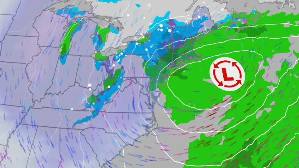
A developing low-pressure system is expected to bring widespread rain, gusty winds, and a sharp temperature drop to the eastern United States between November 12 and 14. While major cities along the I-95 corridor will likely see only rain, higher elevations in the Northeast and Appalachians may receive the season's first accumulating snow. Forecasters note significant uncertainty regarding the storm's exact track and intensity.
Key points
- A deep jet stream trough will cause daytime highs to plummet 20 degrees from Chicago to Atlanta between Wednesday and Friday.
- The National Weather Service has not yet forecast significant snow accumulations for most of New York within its 72-hour window, but chances increase Friday through Sunday.
- Major metropolitan areas like New York City, Philadelphia, and Washington, D.C., are expected to see rain rather than snow due to warmer ground temperatures.
- The best chances for accumulating snow are in the mountains of northern New England, upstate New York, and the Appalachians, including the Poconos and Catskills.
- Lake-effect snow is possible in the Great Lakes region as cold air moves over warmer water, potentially bringing the first snow of the season to areas like Syracuse and Binghamton.
Background
This event follows a relatively warm stretch of weather in late October and early November. Previous nor'easters in September brought hazardous surf and rain to Maine and New Hampshire, but this late-November system is distinct in its potential to bring the first snow of the season to millions. The cold snap is expected to be short-lived, with temperatures returning to above-average levels by next week, contributing to one of the top 10 warmest Novembers on record.
How outlets are covering it
The Weather Channel and USA Today emphasize the uncertainty in the storm's track, noting that models disagree on whether the low will hug the coast or move farther east. FOX 5 New York highlights that major cities along the I-95 corridor will see mostly rain and bitter chill, with snow confined to interior regions. The Democrat and Chronicle focuses on New York, noting that the National Weather Service has not forecast significant snow accumulations for locations like Binghamton and Ithaca within the next 72 hours, but AccuWeather forecasts indicate a rain-snow mix for central New York between Friday and Sunday. All sources agree that the cold snap will be significant, with lows dropping to the 30s as far south as the Florida Panhandle, but the exact amount of snow remains uncertain due to the storm's evolving track.
Why it matters
The potential for the season's first snowfall could impact travel and daily life in the Northeast, particularly in higher elevations and the Great Lakes region. The sharp temperature drop may also affect energy demand and outdoor activities. While major cities are expected to see rain, the uncertainty in the forecast means that residents should monitor updates for potential changes in precipitation type and intensity.
What to watch
Forecasters expect more clarity on the storm's track and intensity as models converge later this week. The National Weather Service will issue shorter-range snowfall forecasts as the storm approaches, providing more specific details on where and when snow may fall. Residents in the Northeast should monitor weather updates for potential changes in precipitation type and intensity, particularly in higher elevations and the Great Lakes region.
- A potential nor’easter could bring rain, snow by later this week The Weather Channel
- Potential for nor'easter increasing, could bring first snow to millions as cold air sweeps across the East FOX Weather
- How much snow could New York get this week? What the latest forecast shows Democrat and Chronicle
- First snow of the season? Potential nor'easter impacts for Philly, NYC and DC region FOX 5 New York
- Northeast on alert for freezing cold, first major snow storm USA Today
Want the full story? Read the original reporting
Read on The Weather Channel