
Nor'easter brings coastal flooding and 60 mph gusts to Northeast
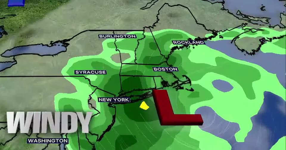
A powerful fall nor'easter is expected to impact the Northeast from Friday through Sunday, bringing hazardous coastal conditions, strong winds, and heavy rain. While inland areas will experience wet, windy weather, the greatest concerns are along the coast, where flooding, beach erosion, and large waves could cause significant damage. The storm is expected to peak Friday night into Saturday, with winds reaching 50-60 mph in some areas and waves ranging from 6 to 17 feet.
Key points
- Coastal flood watch and high surf advisory in effect Friday-Sunday
- Waves expected to range from 6 to 17 feet along Massachusetts coast
- Wind gusts up to 60 mph possible on Cape Cod and Islands
- Rainfall of 1-2 inches inland, 2-6 inches along coast and Cape Cod
- Flash flooding not expected due to spread-out rainfall, but localized ponding likely
Background
This nor'easter follows a pattern of severe weather events in the Northeast, including the August 2026 Midwest storms that left over 1 million customers without power and the ongoing concerns about grid resilience highlighted in September 2026 research on geomagnetic storms. The current event represents the season's first major nor'easter, with impacts concentrated along the coastal corridor from New Jersey to Maine.
How outlets are covering it
Boston 25 News emphasizes the coastal impacts as the primary concern, noting that while inland locations will experience wet, windy weather, the greatest threats are along the coast where flooding, beach erosion, and large waves could cause significant damage. FOX 5 New York highlights the broader regional impact, noting that New York City, Philadelphia, and Washington D.C. are bracing for multiple cycles of tidal flooding, particularly in vulnerable back bays, with wind gusts up to 50 mph and 7-to-10-foot ocean swells. The Washington Post focuses on the peak impacts starting late Friday, when the storm will bring gusts of 40 to 60 mph and localized flooding in a stretch from New Jersey to Maine, describing the event as potentially dangerous for some while a nuisance for others. All sources agree on the timeline and severity, but differ in emphasis: Boston 25 focuses on Massachusetts-specific impacts, FOX 5 on the Mid-Atlantic corridor, and The Washington Post on the broader Northeast region.
Why it matters
The nor'easter poses significant risks to coastal communities, with potential for property damage, beach erosion, and hazardous marine conditions. Residents are urged to monitor forecasts and avoid coastal areas during rough surf and high tide. The storm's prolonged nature means rainfall could accumulate significantly, though flash flooding is not expected to be a major threat due to the spread-out nature of the precipitation. The event highlights the ongoing vulnerability of coastal infrastructure and the importance of preparedness for severe weather events in the Northeast.
What to watch
The storm is expected to gradually weaken through the weekend, with conditions improving by Monday as the system moves away from New England. Residents should continue to monitor forecasts and avoid coastal areas during periods of rough surf and high tide. Local authorities may issue additional warnings or advisories as conditions evolve, and residents should be prepared for potential power outages and localized flooding.
- Fall nor’easter futurecast: Timeline of impacts in Mass. from powerful weekend storm Boston 25 News
- A Powerful Nor’easter Is Taking Shape. How It Could Affect Your Forecast. The New York Times
- Nor'easter threatens Long island with coastal flooding, beach erosion, and wind damage ABC7 New York
- Possible nor'easter threatens Northeast with coastal flooding and high tides FOX 5 New York
- Track where a potent nor’easter will bring heavy rain, winds and waves The Washington Post
Want the full story? Read the original reporting
Read on Boston 25 News