
Edouard dissipates in Texas as Florida faces persistent tropical moisture
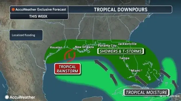
Former Tropical Storm Edouard has weakened and is expected to dissipate over Texas, having delivered 4 to 12 inches of rain to the Gulf Coast. Meanwhile, Florida faces a persistent pattern of heavy downpours and thunderstorms through the Labor Day weekend, driven by residual moisture from Tropical Storm Dolly and two new tropical waves monitored by the National Hurricane Center.
Key points
- Edouard made landfall in Louisiana on Sept. 1 with 60 mph winds and is now dissipating in Texas, bringing 4 to 12 inches of rain to parts of the state.
- Florida is experiencing widespread showers and thunderstorms due to enhanced moisture from the remnants of Tropical Storm Dolly, with rain chances around 70% in Central Florida.
- The National Hurricane Center is monitoring two tropical waves in the Atlantic, one near 39W and another near 56W, as the season approaches its peak on Sept. 10.
- Forecasters warn of a marginal risk for flash flooding in Southwest Florida through Friday, with some areas potentially receiving an additional 5 inches of rain.
- Florida Governor Ron DeSantis declared September as Florida Preparedness Month, urging residents to review disaster plans and emergency supplies before the peak of hurricane season.
Background
The 2026 Atlantic hurricane season has been below average so far, with only four named storms (Arthur, Bertha, Cristobal, and Dolly) forming prior to Edouard. NOAA forecasts suggest 7 to 13 named storms for the season, with peak activity occurring between mid-August and mid-October. Tropical Storm Dolly, which formed on Aug. 27, dissipated early in September but left behind moisture that is now impacting Florida.
How outlets are covering it
Naples Daily News emphasizes the dissipation of Edouard and the broader Atlantic outlook, noting that the National Hurricane Center is watching two tropical waves. WESH highlights the persistent wet pattern in Central Florida, citing 70% rain chances and 2 to 3 inches of rain expected over the next week. Gulf Coast News and Weather focuses on Southwest Florida, warning of heavy afternoon storms and frequent lightning through the week, while ABC7 WWSB stresses the flash flood risk in Sarasota, noting that some areas have already received 8 inches of rain in five days. All sources agree on the elevated moisture and storm activity but differ in their geographic focus and specific rainfall projections.
Why it matters
As the Atlantic hurricane season approaches its peak on Sept. 10, Florida residents face a heightened risk of severe weather, including flash flooding and heavy downpours. The combination of residual moisture from Dolly and new tropical waves creates a volatile environment that could lead to rapid storm development. Preparedness is critical, as the state enters the most active period of the season, with potential impacts on infrastructure, transportation, and public safety.
What to watch
The National Hurricane Center will continue to monitor the two tropical waves in the Atlantic, with a low chance of tropical development in the northeastern Gulf and off the Southeast coast from Sept. 6 to 9. Florida residents should expect continued widespread thunderstorms and heavy rain through the Labor Day weekend, with conditions gradually improving by early next week. Forecasters will closely watch for any signs of rapid development in the eastern Gulf or southwestern Atlantic, as warm waters and enhanced moisture could fuel new storm formation.
- Hurricane forecasters predict tropical downpours into Labor Day weekend Naples Daily News
- Stormy pattern continues Wednesday across Central Florida WESH
- Wet Wednesday for Southwest Florida; Scattered afternoon storms Gulf Coast News and Weather
- Tropical downpours likely through Thursday ABC7 WWSB
- Rain won’t fall evenly today, here’s who gets more WINK News
Want the full story? Read the original reporting
Read on Naples Daily News