
Isaias hits Gulf Coast as Category 3, bringing surge and tornado risks
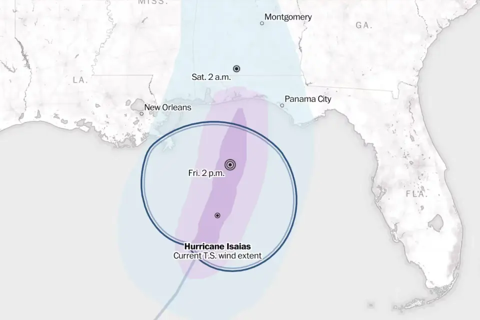
Hurricane Isaias, the first major storm of the 2026 Atlantic season, is making landfall in the Florida Panhandle as a Category 3 hurricane. The storm is expected to bring significant storm surge, heavy rainfall, and tornado risks to the northern Gulf Coast, with impacts stretching inland into Alabama and Georgia through Saturday.
Key points
- Isaias is on track to make landfall near Pensacola or Navarre, Florida, late Friday evening.
- The storm is currently a Category 3 hurricane, though wind shear may weaken it slightly before landfall.
- Storm surge of 5 to 7 feet is forecast for areas including Mobile Bay and the Florida Panhandle.
- Heavy rainfall of 4 to 8 inches, with isolated totals up to 15 inches, is expected in southern Alabama and the Florida Panhandle.
- Tornadoes are possible across coastal Alabama, the Florida Panhandle, and southwestern Georgia, with the threat moving inland on Saturday.
Background
Isaias began as a tropical disturbance in the Gulf of Mexico on October 6, rapidly intensifying into the first hurricane of the 2026 Atlantic season. It has since strengthened to Category 3 status, prompting states of emergency in Florida and Alabama. The late-season arrival is linked to a strong El Niño, which has influenced Atlantic activity this year.
How outlets are covering it
The Washington Post emphasizes the storm's Category 3 status and its path toward the southeastern United States, highlighting flooding and tornado risks. WDSU provides detailed warnings for the Gulf Coast, including specific storm surge levels and wind gusts, while noting that inland areas may experience less severe conditions. WSFA focuses on the impact on Alabama, declaring a 'First Alert Weather Day' and warning of heavy rain and wind gusts up to 60 mph. All sources agree on the landfall timing and the potential for significant damage, but differ in their emphasis on specific regions and the severity of the storm's impact.
Why it matters
Isaias poses a significant threat to the Gulf Coast, with potential for life-threatening storm surge, heavy flooding, and tornadoes. The storm's late-season arrival underscores the impact of climate change on hurricane activity, and its potential to reach the Ohio Valley by midweek next week highlights the broader implications for the region.
What to watch
Residents in warned areas are advised to shelter in place and avoid driving through flooded roadways. The National Hurricane Center will continue to monitor Isaias as it moves inland, with updates on its path and potential impacts. The storm is expected to weaken quickly after landfall, but hurricane conditions could still be felt in parts of Alabama through Saturday.
- Tropical Storm Isaias tracker: Map and projected storm path The Washington Post
- Tracking Tropical Storm Isaias: Interactive storm radar, latest cone, models and satellite WDSU
- Tropical Storm Isaias is forecast to strike the US Gulf Coast as a hurricane AP News
- DeSantis declares state of emergency for 25 Florida counties ahead of growing Gulf storm WFLA
- First Alert: Tropical Storm Isaias strengthens and approaches the Gulf Coast WSFA
Want the full story? Read the original reporting
Read on The Washington Post