
New Mexico Severe Weather Watch: Tornado Risk and Flash Floods Threaten Central and Northern Regions
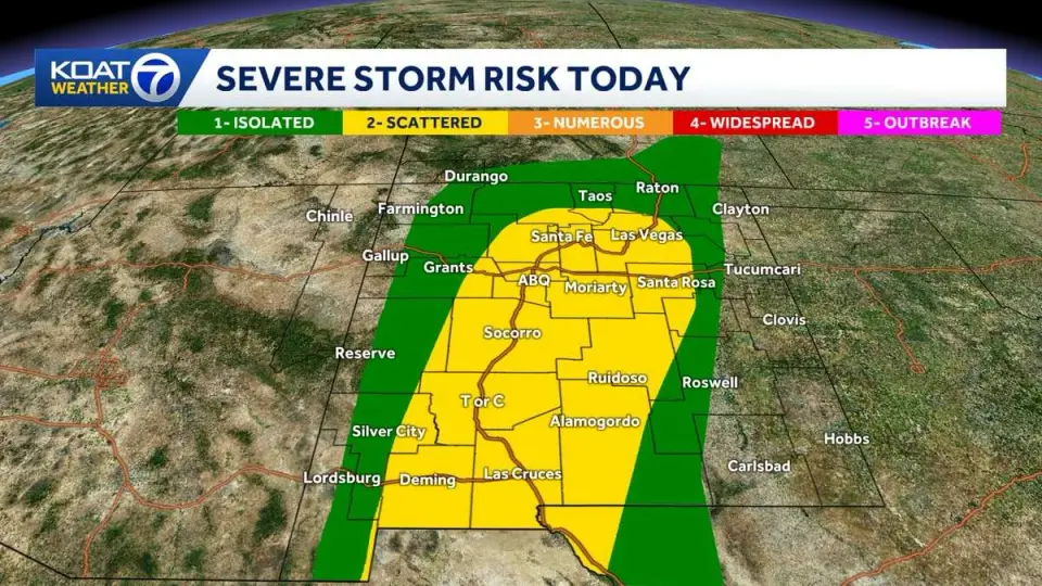
A severe thunderstorm watch covers most of New Mexico through 9 p.m. on October 23, 2026, with risks of large hail, damaging winds, and isolated tornadoes. Central cities like Albuquerque and Santa Fe face potential severe storms, while northern San Juan County has ordered evacuations due to severe flooding. The Storm Prediction Center indicates a low but non-zero tornado risk, with hail up to 3 inches and wind gusts up to 70 mph possible. Flash flooding is a major concern, particularly in the Four Corners area, where rivers may crest at record levels. Rainfall is expected to continue into Saturday, with eastern New Mexico facing the heaviest impacts.
Key points
- Severe thunderstorm watch in effect for most of New Mexico until 9 p.m. MDT on October 23, 2026.
- Tornadoes, large hail (up to 3 inches), and wind gusts up to 70 mph are possible in central New Mexico, including Albuquerque and Santa Fe.
- San Juan County has ordered evacuations due to severe flooding, with roads closed and a shelter area established.
- Flash flooding is a significant threat, particularly in the Four Corners area, where rivers may crest at record levels.
- Rainfall is expected to continue into Saturday, with eastern New Mexico facing the heaviest impacts and potential for additional severe weather.
Background
This event follows a series of severe weather events in the Southwest in October 2026, including rare tornadoes and golf-ball-sized hail in Arizona on October 21, 2026, which caused widespread damage and injuries. The current storm system in New Mexico is part of a broader pattern of unusual late-October severe weather in the region, which has also affected Southern California with heavy rain and flood risks. The Storm Prediction Center's outlook highlights the potential for severe thunderstorms capable of producing very large hail, damaging winds, and isolated tornadoes in central New Mexico.
How outlets are covering it
KOAT emphasizes the tornado and hail risk in Albuquerque and Santa Fe, noting that while the overall tornado risk is low, it cannot be completely ruled out. KOB 4 focuses on the severe thunderstorm watch and the potential for flash flooding, particularly in central and eastern New Mexico, with wind gusts up to 70 mph and hail up to 3 inches. The Tri City Report highlights the immediate impacts in San Juan County, including evacuations, road closures, and a flood watch, with specific rainfall measurements in Farmington, Bloomfield, and Aztec. All sources agree on the severity of the weather, but KOAT and KOB 4 focus more on the broader state-wide risks, while the Tri City Report provides detailed local impacts in San Juan County.
Why it matters
The severe weather poses significant risks to life and property, with potential for tornadoes, large hail, and flash flooding. Evacuations in San Juan County and road closures indicate the immediate danger, while the potential for record river levels in the Four Corners area could lead to widespread flooding. The event underscores the vulnerability of the region to severe weather, even in typically arid areas, and highlights the importance of preparedness and emergency response. The continued rainfall into Saturday and the potential for additional severe weather in eastern New Mexico could exacerbate the situation, leading to further damage and disruption.
What to watch
Residents in central and eastern New Mexico should monitor weather updates and be prepared for potential severe weather, including tornadoes, large hail, and flash flooding. Authorities in San Juan County are continuing to monitor the situation and may issue additional warnings or evacuations as conditions evolve. The National Weather Service is expected to provide updated forecasts and warnings as the storm system moves through the region. Residents are advised to avoid flooded roadways and seek shelter if necessary, particularly in areas with low water crossings.
- Tornadoes & large hail possible in Albuquerque with flooding in northern New Mexico KOAT
- Storms could bring big hail and flash floods to New Mexico overnight into Saturday KOB 4
- Flood Warnings issued for many areas and waterways from recent rains, and storm chances continue today with a severe threat. KOAT
- Southwest faces more severe weather, flash flooding as Colorado Gov. declares state of emergency FOX Weather
- Tornado and flood watch issued for San Juan County Tri City Record
Want the full story? Read the original reporting
Read on KOAT