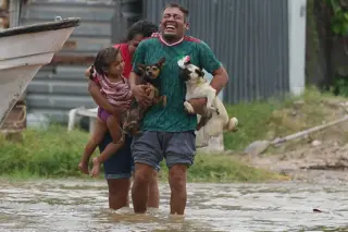
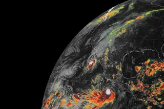
Hurricane Polo made landfall in Mexico's Baja California Sur as a Category 3 storm, bringing life-threatening winds and flash floods. Its remnants have since moved into the United States, merging with other weather systems to create a 'hybrid storm' that poses significant flooding risks across the Southwest and central US through mid-week.
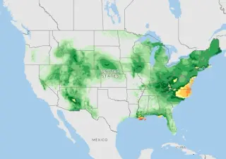
Hurricane Polo, which briefly reached Category 5 status, has dissipated over Mexico but its remnants are now driving severe flooding across the southwestern United States. The storm made landfall in Baja California Sur on Monday and moved northeast into Sonora, bringing heavy rain to the U.S. border. As of Tuesday, more than 30 million people from Arizona to Iowa face flash flood risks. In southern New Mexico, the McLeod Dam in Doña Ana County is under critical stress, prompting evacuation orders and emergency pumping operations. The National Weather Service has issued flash flood watches spanning over 1,200 miles, with rainfall rates reaching 4 inches per hour in some areas. While the storm has weakened, its moisture is combining with other weather systems to create a significant threat through the week.
Hurricane Polo made landfall in Mexico’s Baja California Sur on Monday night, sending moisture-rich remnants into the United States. These remnants are merging with an upper-level trough to create a 'hybrid storm' that threatens life-threatening flash floods across the Southwest and Plains through Wednesday. Flood watches are currently in effect for approximately 28 million people, with the highest risks concentrated in Arizona, New Mexico, Colorado, Kansas, Oklahoma, and Texas.
Hurricane Polo made landfall in Mexico’s Baja California Sur on Monday night, sending moisture-rich remnants into the U.S. Southwest. These remnants are merging with an upper-level trough to create a 'hybrid storm' that threatens life-threatening flash floods across the Southwest and Plains through Wednesday. Flood watches are currently in effect for approximately 28 million people, with the highest risks concentrated in Arizona, New Mexico, Colorado, Kansas, Oklahoma, and Texas.
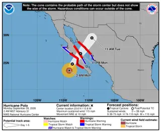
Category 3 Hurricane Polo made landfall in Baja California, Mexico, on Monday evening with 115 mph winds, bringing life-threatening flash floods and storm surges. While the storm weakened upon hitting land, its remnants combined with other weather systems to create a 'hybrid storm' that is causing widespread heavy rainfall and flooding risks across the southwestern and central United States through mid-week.
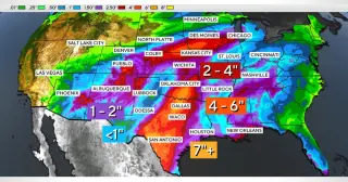
The remnants of Hurricane Polo are moving inland from the Pacific, bringing significant rainfall and flood risks to Texas, New Mexico, and the Midwest. Central Texas faces the highest threat, with potential totals of 4 to 12 inches, while Houston expects 1 to 4 inches later in the week. Cooler temperatures are also forecast across affected regions.
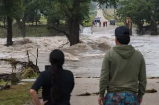
Three people died after flash floods swept through Two Grey Hills on the Navajo Nation: a 7-year-old girl, Lucy Allison Mike, who had been crowned Miss Sanostee Day School and was about to celebrate her birthday, and two women, Elsie Begay and Dora Franklin, who both worked for the Department of Education.
Parts of southeastern Texas were deluged as Tropical Storm Edouard dumped as much as 30 inches of rain in 24 hours (with rates up to five inches per hour near Houston), triggering dangerous flash floods, stranded residents, and road closures while more than 1,100 state responders and multiple agencies worked on rescue operations.
Floods triggered by a glacial collapse have devastated Nepal and Tibet, washing away communities and leaving thousands missing as the death toll rises; about 90 Americans are unaccounted for, and the U.S. has pledged $500,000 in aid as rescue teams continue searching amid widespread damage along the Bhotekoshi River and surrounding areas.
Forecasters expect Tropical Storm Bertha to form from a Gulf Coast depression, while a central U.S. heat dome drives dangerous heat (indices up to about 116°F) and a cold front could trigger severe thunderstorms with flash floods from the Midwest to the Mid-Atlantic; wildfire smoke from Canadian fires blankets the Great Lakes region, worsening air quality, and eight flood-related deaths have been reported in Texas, Arizona, and Utah.
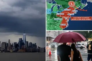
Torrential thunderstorms dumped about 2–4 inches of rain across New York City, sending floodwaters into streets and subway entrances (including Canal Street in SoHo) and prompting major transit disruptions, flight delays, and power concerns as officials urged residents to stay safe amid worsening conditions and a visible improvement in air quality from Canadian wildfires.
More than 90 million Americans are under a Level 2 (and higher) severe weather threat this weekend as a slow-moving cold front sweeps from the Ohio Valley into the Northeast, bringing widespread thunderstorms, damaging winds, heavy rain and the possibility of tornadoes. Flash-flood threats are in place for parts of the Ohio Valley Friday and for New York City and neighboring areas Saturday, with the Northeast likely to bear the brunt on the weekend. The pattern comes amid a heat dome and wildfire smoke that could affect temperatures, but forecasters expect the front to bring relief by Sunday.
Texas’ Hill Country and southwest Texas endured a third night of heavy rain and flash floods, with at least two fatalities and numerous evacuations. The National Weather Service warned 2–4 inches of rain, with isolated areas up to 8 inches, threatening major flooding along the Pedernales, Guadalupe, Frio and Nueces rivers. State officials mobilized responders, opened floodgates and launched a flood-relief fund as communities brace for more downpours and potential further evacuations.
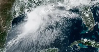
Tropical Storm Arthur, the first named storm of the season after forming off Texas, is expected to bring 5–10 inches of rain (with isolated totals up to 20 inches) from Texas across the Southeast, triggering flash flood concerns and prompting disaster declarations in parts of Texas; forecasters say rainfall duration and movement will largely drive flooding risk, even as El Niño keeps overall hurricane activity relatively subdued for the year.