
North Texas Tornado Watch Issued as Cold Front Brings Severe Storms on Election Day
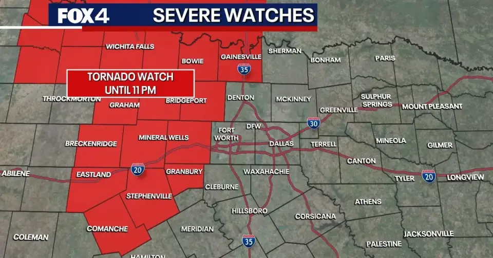
A tornado watch is in effect for several northwest North Texas counties until 11 p.m. Monday as a strong cold front brings severe storms, including 60 mph wind gusts and quarter-sized hail, to the region on election night.
Key points
- A tornado watch covers Hood, Palo Pinto, Parker, Comanche, Jack, Wise, Cooke, and Erath counties until 11 p.m. Monday.
- Storms are expected to develop between 4 p.m. and 6 p.m. Sunday and reach the I-35 corridor by 10 p.m.
- Primary threats include damaging wind gusts up to 60 mph, large hail, and localized flooding.
- Temperatures will drop from 85 degrees to 73 degrees behind the front, with dry conditions returning by the early morning commute.
- Voters in eastern and southeastern counties may experience rain at 7 a.m., with conditions improving by afternoon.
Background
This severe weather event follows a pattern of significant storm activity in the region, including the October 2026 remnants of Hurricane Isaias that caused tornadoes and flooding in North Carolina. Additionally, North Texas saw record early voting numbers in October, highlighting the importance of weather conditions affecting voter access on election day.
How outlets are covering it
FOX 4 News emphasizes the impact on the Dallas-Fort Worth metroplex, noting that rain will clear by 4 a.m. and advising eastern voters to vote in the afternoon. NewsChannel 10 focuses on the broader Panhandle region, warning of wind gusts up to 75 mph and isolated tornadoes, with storms developing from New Mexico and moving eastward into Amarillo by 9 p.m. CST.
Why it matters
The severe weather poses risks to property and infrastructure during a critical election period, potentially affecting voter turnout and access in affected counties. The cold front also marks a significant shift to seasonal temperatures, impacting daily life and outdoor activities.
What to watch
Following the storms, strong northwest winds up to 25 mph will dry out the area quickly. The rest of the week is expected to have comfortable conditions with highs in the 70s and mostly rain-free weather, aside from a low rain chance along the Red River on Thursday.
- Dallas weather: Severe storms target DFW overnight ahead of Election Day FOX 4 News Dallas-Fort Worth
- FIRST ALERT: Severe thunderstorms possible late tonight NewsChannel 10
- Tornado threat in Texas, with Houston’s rain chances highest on Election Day Houston Chronicle
- DFW Weather: Severe thunderstorms possible Monday night into Tuesday morning WFAA
- Cold front’s arrival in San Antonio could change the week ahead MySA
Want the full story? Read the original reporting
Read on FOX 4 News Dallas-Fort Worth