
Severe thunderstorms threaten Metro Detroit with potential tornadoes.
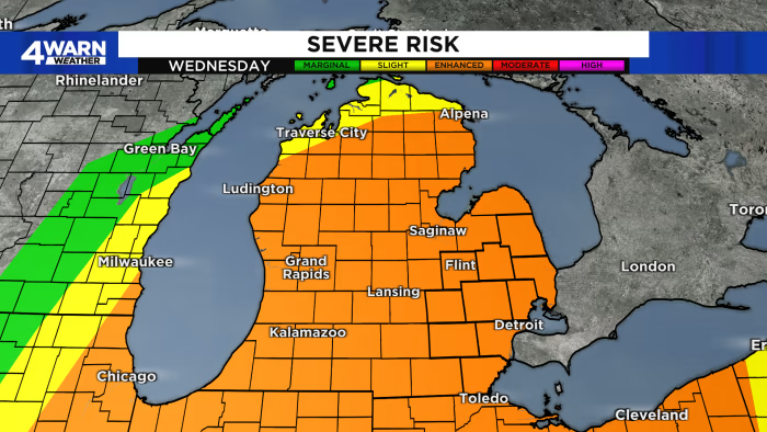
Severe thunderstorms are expected to hit Metro Detroit on Wednesday, with a strong cold front bringing the potential for damaging winds, large hail, and even tornadoes. The Storm Prediction Center has placed most of the region under an Enhanced Risk for severe thunderstorms, with Southeastern Michigan in a “Significant hatching” indicating a higher risk than normal. The greatest time frame for severe weather looks to be around lunchtime and working through the afternoon and into the early evening hours. The cold front will bring an end to any type of severe weather for Metro Detroit, and sets us up for some sunshine, drier weather, and colder temperatures for the Detroit Tigers home opener on Thursday.
- Severe thunderstorms move into region midweek in Metro Detroit -- here's what to expect WDIV ClickOnDetroit
- Michigan under tornado, severe thunderstorm bullseye MLive.com
- Rain continues before potentially severe storms arrive Wednesday in Metro Detroit Click On Detroit | Local 4 | WDIV
- Cloudy Tuesday with severe weather potential Wednesday; Here's two paths storms could take FOX 2 Detroit
- Tonight's Forecast: A few rounds of storms, some may be severe FOX 17 West Michigan News
Reading Insights
0
8
4 min
vs 5 min read
86%
842 → 115 words
Want the full story? Read the original article
Read on WDIV ClickOnDetroit