
Texas Mobilizes 1,900 Responders as Hurricane Polo Remnants Threaten Major Flooding
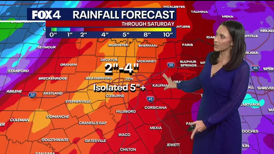
Remnants of Hurricane Polo are bringing a severe flash flood threat to Texas, prompting Governor Greg Abbott to activate over 1,900 state responders. Heavy rainfall of 2 to 7 inches is expected across the state, with the highest risks concentrated along the I-35 corridor and in North Texas. Officials urge residents to prepare for potential road closures and life-threatening water levels.
Key points
- A flood watch is in effect for North Texas, with 2 to 4 inches of rain expected, and isolated areas potentially receiving over 5 inches.
- Governor Abbott activated the State Emergency Operations Center for 24/7 operations and deployed 1,900 responders, including high-water vehicles and rescue helicopters.
- Heavy rain is forecast to move from West Texas and the Panhandle on Tuesday to the I-35 corridor by Wednesday, with the heaviest impact expected Thursday.
- Officials warn that six inches of fast-moving water can cause drivers to lose control, urging the public to 'turn around, don't drown.'
- The weather system is expected to bring a significant drop in temperatures, ending the recent heat wave across the region.
Background
This event follows recent severe weather patterns in the region, including a tropical cyclone threat on the Texas coast in August and widespread flooding risks in the Northeast. The current system is the latest in a series of tropical remnants affecting the southern United States, with New Mexico also facing a multi-day flash flood threat from the same storm system.
How outlets are covering it
FOX 4 Dallas focuses on the local impact for North Texas, highlighting the end of a heat wave and the specific commute disruptions expected Thursday. FOX 7 Austin and the Texas Governor's office emphasize the statewide scale of the emergency, detailing the massive mobilization of state resources and the potential for a stalled front to cause 'incalculable' rainfall. While all sources agree on the threat, the state-level reports stress the severity of the event, comparing it to the deadly July flooding, whereas the local report focuses on the immediate weather shift and temperature drop.
Why it matters
The activation of over 1,900 state responders and the 24/7 operations of the Emergency Operations Center indicate a high-level threat to public safety. The potential for 10 inches of rain in some areas could lead to significant infrastructure damage, road closures, and life-threatening flash flooding, requiring immediate public preparedness and coordination between state and local agencies.
What to watch
The heavy rain is expected to peak Thursday and continue through Friday before tapering over the weekend. The Emergency Operations Center will remain in 24/7 operations to coordinate response efforts. Residents are advised to monitor local forecasts and avoid flooded roadways as the system moves across the state.
- Dallas weather: Sept. 29 morning forecast FOX 4 News Dallas-Fort Worth
- State officials give update on storm preparations FOX 7 Austin
- Flood Watch issued, heavy rain and severe threat KXAN Austin
- Governor Abbott Holds Severe Weather Briefing, Activates Additional State Emergency Response Resources Office of the Texas Governor (.gov)
- North Texas flood watch starts Wednesday as severe storms move into the region Yahoo
Want the full story? Read the original reporting
Read on FOX 4 News Dallas-Fort Worth