
Unpredictable September Nor’easter Threatens East Coast with Rain and Coastal Flooding
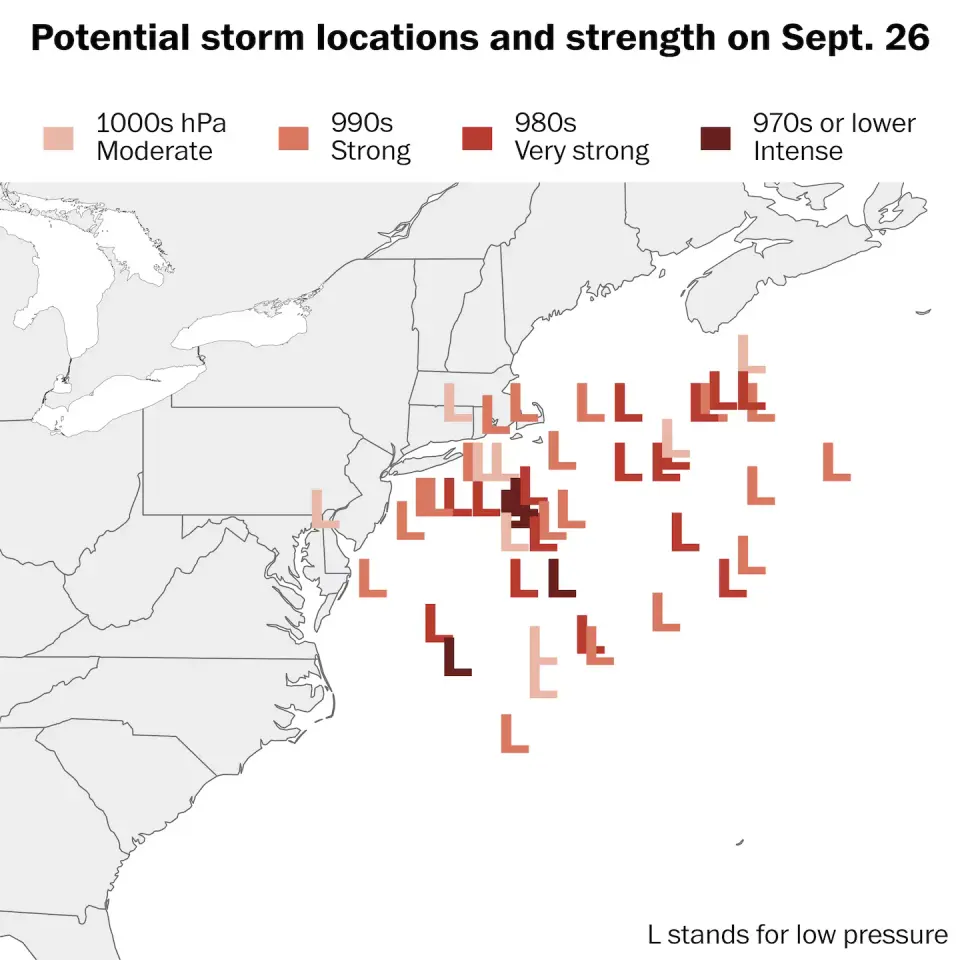
A rare September nor’easter is forecast to intensify off the Mid-Atlantic coast this week, potentially bringing heavy rain, strong winds, and coastal flooding to the Eastern Seaboard. While the exact track remains uncertain, forecasters warn of hazardous marine conditions and beach erosion from North Carolina to New York, with a small chance the system could transition into a tropical storm by the weekend.
Key points
- A rare September nor’easter is expected to form near the Mid-Atlantic coast later this week, with impacts dependent on its proximity to the shore.
- The National Weather Service warns of multiple days of strong onshore winds, which could cause coastal flooding and beach erosion, particularly as the full moon raises tides.
- Eastern North Carolina may see increased rain on September 24, followed by precipitation in New England on September 25 and 26, with cooler-than-usual temperatures in the Mid-Atlantic.
- Hazardous marine conditions, including dangerous surf and potential ocean overwash, are expected along the Outer Banks starting September 23.
- There is a 20% chance the system could transition into a tropical storm south of New England by the weekend, though this is unlikely to significantly change coastal impacts.
Background
This event follows recent severe weather on the East Coast, including a line of thunderstorms in September that prompted 51 shelters in New York City due to flash-flood risks. Earlier in the month, Hurricane Marie skimmed past California, and a cyclone affected Hawaii, highlighting a period of active weather systems across the United States.
How outlets are covering it
The Washington Post emphasizes the rarity of a September nor’easter and the uncertainty of its track, noting that impacts will depend on how close the storm stays to the coast. USA Today highlights the potential for the system to morph into a tropical storm and provides specific timelines for rain and wind impacts, citing the National Weather Service and AccuWeather. WCVB focuses on local Boston weather, detailing daily forecasts with significant rainfall and wind shifts, particularly noting a 90% chance of rain on Friday and strong winds on Saturday. While all sources agree on the potential for rain and wind, USA Today provides the most detailed timeline and the highest level of uncertainty regarding the storm's classification, whereas The Washington Post focuses on the broader regional impact and the rarity of the event.
Why it matters
The potential for a September nor’easter to bring heavy rain, strong winds, and coastal flooding to the East Coast is significant due to the unusual timing and the potential for hazardous marine conditions. The uncertainty of the storm's track and the possibility of it transitioning into a tropical storm add to the complexity of forecasting and preparedness. Residents along the coast, particularly in North Carolina and New England, need to be aware of the potential for coastal flooding, beach erosion, and dangerous surf conditions, especially as the full moon raises tides. The event also highlights the importance of monitoring weather patterns and being prepared for severe weather, even outside of the traditional hurricane season.
What to watch
Forecasters will continue to monitor the storm's track and intensity over the coming days, with updates expected as the system approaches the Mid-Atlantic and Northeast. Residents along the East Coast should stay informed through local weather services and be prepared for potential rain, wind, and coastal flooding. The National Weather Service will provide further guidance on the storm's path and potential impacts, particularly as the full moon raises tides and increases the risk of coastal flooding. The possibility of the system transitioning into a tropical storm will also be closely monitored, though this is considered a low-probability scenario.
- Rare September nor’easter could bring rain, wind and waves to East Coast The Washington Post
- Developing nor’easter to batter East Coast for days with strong winds, flooding and dangerous surf FOX Weather
- Potential nor'easter could bring rain, wind and flooding to East Coast USA Today
- Potential weekend coastal storm could bring flooding, 50 mph winds and rain to New England wcvb.com
- A nor’easter could hit Northeast, including New York, Boston The Weather Channel
Want the full story? Read the original reporting
Read on The Washington Post