
Atypical Late-July Storm System Threatens Northeast with Flash Floods and Severe Winds
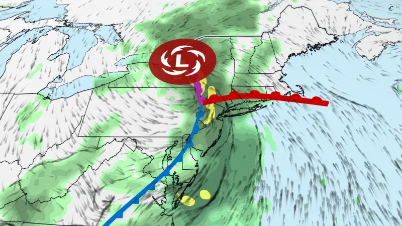
An unusually powerful storm system is moving through the Northeast, bringing a high risk of flash flooding and severe thunderstorms from Monday through Thursday. The system, fueled by extreme moisture from the Atlantic and Gulf, is expected to drop up to a month's worth of rain in some areas. The heaviest impacts are forecast for the New York Tri-state area, Philadelphia, and parts of New England, with potential for significant travel delays and urban flooding.
Key points
- The storm system is unusually strong for late July, with intensity comparable to typical fall or winter storms.
- The system is fueled by extreme moisture from the Atlantic and Gulf, leading to multiple rounds of heavy rain and thunderstorms.
- The heaviest rainfall is expected in the New York Tri-state area, Philadelphia, and parts of New England, with potential for flash flooding in urban and poor drainage areas.
- The storm is expected to linger over the Northeast through at least Thursday, with travel delays likely at airports and on roads.
- The system is expected to weaken and move out of the Northeast on Friday, but scattered showers and storms may continue.
Background
This storm system follows a series of severe weather events in the Northeast earlier in July, including flash flooding in New York City on July 18 and a widespread severe weather threat across the East Coast in mid-July. The current system is also occurring during a period of elevated heat and wildfire smoke across the central and southern U.S., and as Tropical Storm Bertha is tracking toward the Gulf Coast.
How outlets are covering it
CNN emphasizes the unusual strength of the storm for late July, noting that it is comparable to systems typically seen in October, November, or December. CNN also highlights the extreme moisture from the Atlantic and Gulf as a key factor in the storm's intensity. FOX 29 Philadelphia focuses on the immediate impact on the Philadelphia area, with severe thunderstorm and flash flood warnings in effect on Monday and a flash flood watch for Tuesday through Wednesday. Gothamist, covering New York City, notes that the storm system is expected to move slowly through the region, with the heaviest rain starting Tuesday afternoon into Wednesday morning. Gothamist also highlights the uncertainty in pinpointing the exact location of the heaviest rainfall, which is preventing the National Weather Service from issuing a flood watch for New York City at this time.
Why it matters
The storm system poses a significant risk of flash flooding and severe thunderstorms in the Northeast, with potential for significant travel delays and urban flooding. The unusual strength of the storm for late July, combined with extreme moisture from the Atlantic and Gulf, highlights the potential for severe weather events in the region. The storm also underscores the need for residents to be prepared for severe weather and to take precautions to protect themselves and their property.
What to watch
The storm system is expected to linger over the Northeast through at least Thursday, with travel delays likely at airports and on roads. The heaviest rainfall is expected in the New York Tri-state area, Philadelphia, and parts of New England, with potential for flash flooding in urban and poor drainage areas. The system is expected to weaken and move out of the Northeast on Friday, but scattered showers and storms may continue. Residents are advised to stay informed about weather updates and to take precautions to protect themselves and their property.
- An unusually strong storm for summer will fuel a Northeast flash flood threat this week CNN
- Flood Watch issued for NYC and much of Tri-State area ahead of flooding downpours threat on Tuesday ABC7 New York
- Philadelphia weather: Severe Thunderstorm Warning until 4:30 pm FOX 29 Philadelphia
- Excessive rainfall and storms on the way PIX11
- Rain and storms ahead for NYC after a picture-perfect weekend Gothamist
Want the full story? Read the original reporting
Read on CNN