
Hurricane Polo becomes second-strongest Eastern Pacific storm on record
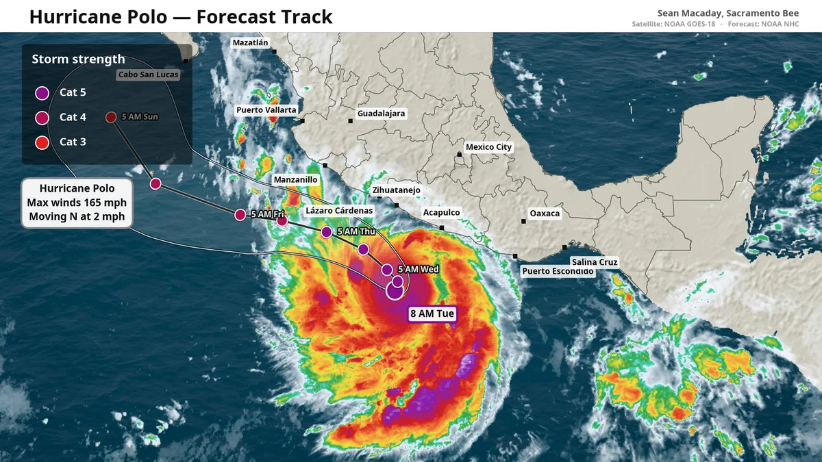
Hurricane Polo has rapidly intensified into a Category 5 storm with 180 mph winds, becoming the second-strongest hurricane ever recorded in the Eastern Pacific. Fueled by record-breaking El Niño waters, the storm is moving northwest toward Baja California, posing severe flood risks to Mexico's southwest coast while remaining offshore.
Key points
- Polo reached 180 mph winds and 892 mb pressure, ranking second only to 2015's Hurricane Patricia in the Eastern Pacific.
- The storm underwent extreme rapid intensification, gaining 110 mph in 24 hours, a rate comparable to 2023's Hurricane Otis.
- El Niño-driven Kelvin waves are providing unusually warm water, extending the hurricane's potential lifespan into November.
- Polo is forecast to stay offshore but will bring 3-8 inches of rain to Mexico's Guerrero, Michoacán, and Jalisco states, risking deadly flooding.
- Mexico's President Claudia Sheinbaum warned residents of coastal states to remain vigilant as the storm approaches the Baja California peninsula.
Background
This event follows a hyperactive Pacific season already marked by Hurricanes Karina and Lowell. Earlier reports noted a potential Fujiwhara interaction between Polo and Tropical Storm Odalys, though current forecasts focus on Polo's independent intensification. The current El Niño is the strongest on record, with sea surface temperatures exceeding 3.05°C above average, a factor previously linked to the 2015 Super El Niño that produced Hurricane Patricia.
How outlets are covering it
The Sacramento Bee emphasizes the role of El Niño Kelvin waves in fueling Polo's rapid growth and warns of extended hurricane activity through November. CNN highlights the storm's global ranking, noting its 180 mph winds tie it with West Pacific super typhoons as the strongest storm of 2026. The BBC focuses on the immediate humanitarian risk, quoting President Sheinbaum on the threat of life-threatening flooding and mudslides in southwestern Mexico. The New York Times describes the intensification as 'truly remarkable' according to forecasters, while noting the storm's slow movement and potential for heavy rainfall in the region.
Why it matters
Polo's rapid intensification underscores the increasing power of Pacific hurricanes due to warming oceans and El Niño conditions. While the storm is not expected to make landfall, its potential to cause catastrophic flooding in Mexico and its ability to maintain strength into late fall pose significant risks to the southwestern United States and Mexico's Pacific coast.
What to watch
Forecasters expect Polo to maintain Category 5 status for several days as it moves northwest. Tropical storm alerts are in effect for Mexico's southwest coast, with heavy rainfall expected through Thursday. The storm's track remains uncertain after it approaches Baja California this weekend, with a small chance it could turn north toward the southwestern U.S. in early October.
- Aided by El Niño, Hurricane Polo explodes to Category 5 as it nears Baja California Sacramento Bee
- Hurricane Polo explodes into rare Category 5 monster after feasting on hot El Niño water CNN
- 'Extremely dangerous' Hurricane Polo intensifies to rare category 5 storm BBC
- Hurricane’s Explosive Growth Off Mexico Was ‘Truly Remarkable,’ Forecasters Say The New York Times
- Hurricane Polo churns off Mexico’s Pacific coast as ‘one of the strongest storms ever’ The Hill
Want the full story? Read the original reporting
Read on Sacramento Bee