
Subtropical Storm Josephine cuts off NC Outer Banks as king tides threaten Southeast
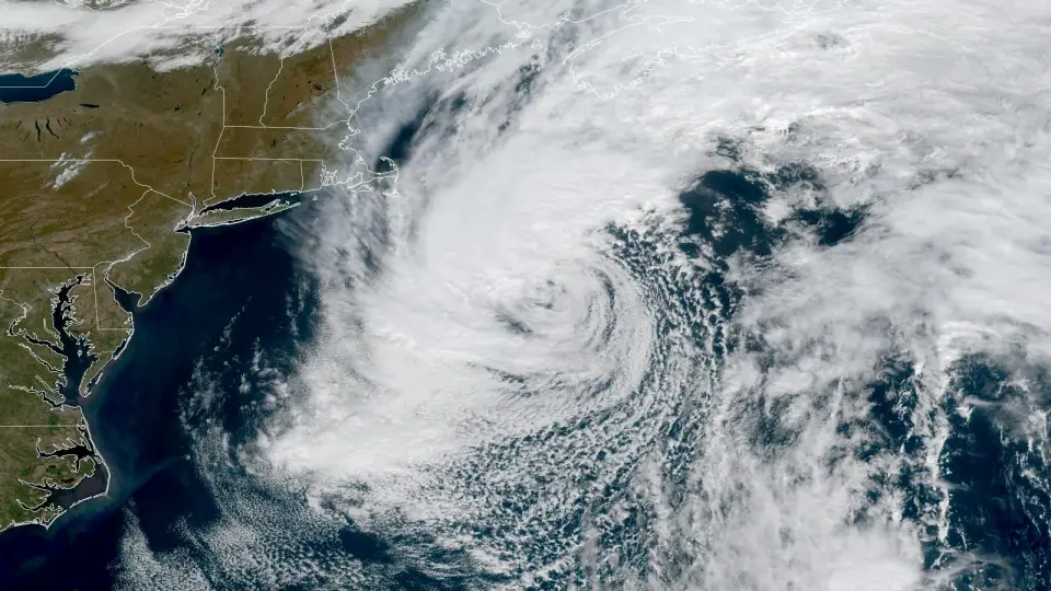
Subtropical Storm Josephine has formed in the Atlantic, cutting off the North Carolina Outer Banks via NC-12 and bringing coastal flooding to the Northeast. The storm is expected to intensify into an extratropical cyclone with hurricane-force winds before dissipating by Sunday. Simultaneously, king tides are forecast to bring some of the highest water levels in a decade to the Southeast U.S. coast, including Miami and Charleston, while Tropical Storm Vance rapidly intensifies in the Eastern Pacific.
Key points
- Josephine formed late Wednesday as the 10th named system of the 2026 Atlantic season, the first subtropical storm of the year.
- The storm is moving northeast at 12-17 mph with 65 mph winds, forecast to reach hurricane-force winds as it transitions to an extratropical system by Friday.
- NC-12, the only highway to the Outer Banks, is closed due to extensive damage from storm surge and overwash, requiring emergency ferry service.
- King tides peaking between Oct. 25 and 28 are expected to cause major flooding in the Southeast, with water levels in Miami and Charleston nearing 10-year highs.
- Tropical Storm Vance in the Eastern Pacific is forecast to become a major Category 3 hurricane by Saturday, potentially tying the record for most major hurricanes in a season.
Background
The 2026 Atlantic hurricane season has been notably quiet, with only one hurricane (Isaias) forming late in October due to strong El Niño conditions. Isaias made landfall in Florida on Oct. 9 as a Category 2 storm, marking the first hurricane of the season. The current ACE index of 19 is 17% of average for the date, reflecting suppressed activity. In contrast, the Eastern Pacific has been hyperactive, with 22 named storms already this year.
How outlets are covering it
Yale Climate Connections emphasizes the unique hybrid nature of Josephine, noting its subtropical characteristics and the potential for rapid intensification before transitioning to extratropical. CNN highlights the storm's acceleration away from the coast and the broader context of a quiet Atlantic season suppressed by El Niño. The Chicago Tribune focuses on the immediate impacts, describing Josephine as a 'powerful extratropical low' with hurricane-force winds, and notes the gale warnings for the Northeast. WXII provides detailed local impacts, particularly the closure of NC-12 and the ongoing risk of flooding in the Outer Banks, while also mentioning a new area of interest in the central Atlantic.
Why it matters
Josephine's formation and the subsequent king tides highlight the compounding risks of coastal flooding and infrastructure vulnerability. The closure of NC-12 isolates thousands of residents, while the forecasted king tides threaten major urban areas like Miami and Charleston. Additionally, the rapid intensification of Vance in the Eastern Pacific underscores the extreme activity in that basin, with potential impacts on Jalisco, Mexico, following earlier storms.
What to watch
Josephine is expected to dissipate by Sunday as it moves into colder waters and is absorbed by a larger low-pressure system. King tides will peak between Oct. 25 and 28, with potential for major flooding in the Southeast. Vance is forecast to become a major hurricane by Saturday and may approach the Jalisco coast by early next week. A new area of interest in the central Atlantic may briefly intensify but is expected to be torn apart by upper-level winds.
- Subtropical Storm Josephine forms in the Atlantic Yale Climate Connections
- Subtropical Storm Josephine heads away from East Coast CNN
- Josephine brings coastal flooding and strong winds to the Eastern Seaboard Chicago Tribune
- Post-Tropical Cyclone Josephine getting stronger off East Coast | Hurricane-force wind risk WXII
- Coast-hugging nor'easter churns up high waves, strong winds The Weather Channel
Want the full story? Read the original reporting
Read on Yale Climate Connections