
Edouard weakens to depression after landfall, bringing heavy rain to SE Texas
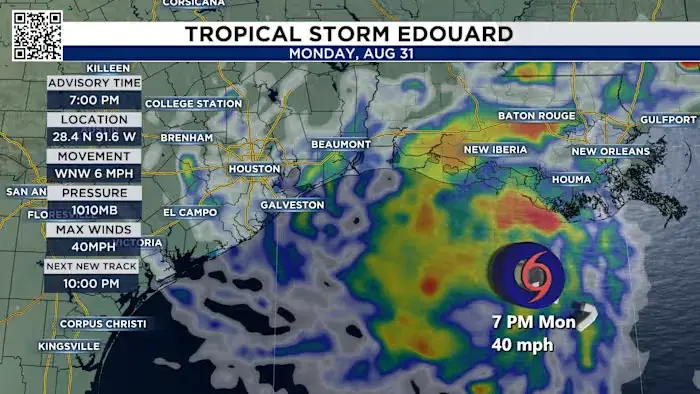
Tropical Storm Edouard made landfall near the Texas-Louisiana border on Tuesday, September 1, 2026, before weakening into a tropical depression. The system brought significant rainfall and wind gusts to southeast Texas, with the heaviest impacts concentrated east of I-45. While Houston experienced moderate rain and wind, areas like Chambers County and the Bolivar Peninsula faced higher totals and a tropical storm warning. The storm is expected to dissipate by Wednesday night, though flash flooding remains a risk in low-lying areas.
Key points
- Edouard made landfall near Johnson Bayou, Louisiana, on Tuesday afternoon with maximum sustained winds of about 35 mph.
- A tropical storm warning was issued for Chambers County, including the Bolivar Peninsula, High Island, and Crystal Beach, with wind gusts exceeding 40 mph.
- Rainfall totals of 3-5 inches were expected across southeast Texas, with isolated amounts reaching 6-9 inches east of I-45; some areas may see up to 12 inches.
- A flood watch was in effect for the eastern half of southeast Texas from late Monday through Wednesday morning.
- The storm weakened to a tropical depression by Wednesday and is expected to dissipate by Wednesday night, moving north-northwest at approximately 5 mph.
Background
Earlier forecasts indicated Edouard might strengthen to a Category 1 hurricane before landfall, but it ultimately arrived as a tropical storm and quickly weakened. Houston-area schools had canceled Tuesday classes in anticipation of severe weather, though impacts on the city were less severe than initially feared. Stage 2 flood alerts were active east of I-45, while Stage 1 alerts covered areas west of the freeway.
How outlets are covering it
KPRC emphasized the reduced rain impact on Houston due to the storm's eastward shift, highlighting higher totals in Chambers and Liberty counties. ABC News focused on the broader threat of heavy rain through Wednesday and the possibility of tornadoes in southwest Louisiana. WESH reported on the storm's weakening to a tropical depression and the potential for significant flash and river flooding. nola.com noted the storm's potential to strengthen before landfall, though it ultimately weakened after making landfall.
Why it matters
The event highlights the variability in tropical storm forecasts and the localized nature of severe weather impacts. While Houston avoided the worst of the storm, southeast Texas communities faced significant flooding and wind risks, underscoring the importance of localized weather alerts and preparedness.
What to watch
The storm is expected to dissipate by Wednesday night. Residents in affected areas should continue to monitor for potential flash flooding and avoid flooded roads. Updates on rainfall totals and any residual impacts will be provided by local meteorologists and the National Hurricane Center.
- Tropical Storm Edouard: Here’s the Timeline for Houston & SE Texas Click2Houston
- Tropical Storm Edouard could strengthen to hurricane before landfall: Officials ABC News - Breaking News, Latest News and Videos
- Tropical Storm Edouard Growing Stronger as it Nears the Gulf Coast The New York Times
- Tropical Storm Edouard strengthening before reaching Texas, Louisiana WESH
- TS Edouard expected to strengthen, make landfall as a Category 1. See Louisiana forecast. nola.com
Want the full story? Read the original reporting
Read on Click2Houston