Tag

Flood Watch

All articles tagged with #flood watch

Hurricane Warning Hits Kauai and Niihau as Lowell Approaches Hawaii
weather1 month ago

Hurricane Warning Hits Kauai and Niihau as Lowell Approaches Hawaii

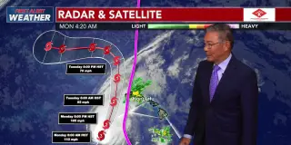
A Hurricane Warning is in effect for Kauai and Niihau as Category 3 Hurricane Lowell approaches Hawaii, with hurricane conditions, high surf and heavy rainfall expected within the next 24 hours. A statewide Flood Watch remains in effect through Tuesday morning, and a High Surf Warning covers southern and southwestern shores statewide. Residents should monitor official updates and take necessary precautions.
Hurricane Lowell Sparks High Surf, Rain, and Flood Risk Across Hawaii
weather1 month ago

Hurricane Lowell Sparks High Surf, Rain, and Flood Risk Across Hawaii

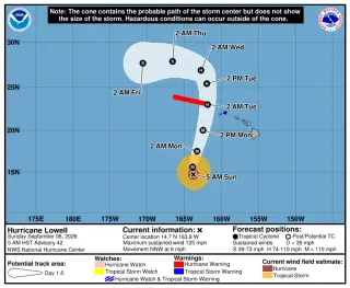
Category 3 Hurricane Lowell is tracking toward Hawaii with 125 mph winds and its eye forecast to pass 100–200 miles west of Niʻihau Monday night. It will drive large surf (peaking up to 14 feet on east shores and 12 feet on south shores) and bring heavy rainfall statewide (Big Island 2–6 inches with isolated 10 inches; Kauaʻi 6–10 inches, potentially higher in spots). A flood watch is in effect statewide and tornadoes are possible in rainbands. Residents should monitor forecasts, secure outdoor items, and avoid floodwaters.

Hurricane Lowell Holds at Cat 4 as Kauaʻi Braces for Monday Tropical-Storm Conditions
hawaii-weather1 month ago

Hurricane Lowell Holds at Cat 4 as Kauaʻi Braces for Monday Tropical-Storm Conditions

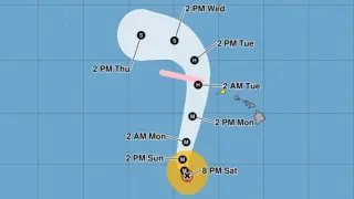
Category 4 Hurricane Lowell remains powerful off Hawaii as Kauaʻi County is under a tropical-storm watch with tropical-storm conditions possible by late Monday. Forecasts show a northwest then north-northeastward track with increasing forward speed, and potential 1–3 feet of storm surge in surge-prone areas. Rainfall could total 4–8 inches on Kauaʻi (up to 12+ inches in spots), 2–6 inches on the Big Island (isolate up to 10 inches), and 2–4 inches on Maui, raising risks of flash flooding and mudslides. Officials urge monitoring forecasts, stocking emergency supplies, and avoiding floodwaters while preparations continue.

Edouard Approaches SE Texas, Flood Watch in Place as Rain Totals Shift East
weather1 month ago

Edouard Approaches SE Texas, Flood Watch in Place as Rain Totals Shift East

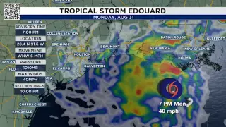
Tropical Storm Edouard has formed in the Gulf and is expected to make landfall near Sabine Pass on Tuesday, bringing heavy rain and gusty winds to Southeast Texas. A Tropical Storm Warning is in effect for Chambers County and a Flood Watch covers eastern Southeast Texas from late Monday through Wednesday morning. Forecasts call for 3–5 inches of rain, with isolated 6–9 inches and the heaviest totals east of I-45, raising street-flood risk as bands move inland. Rain should reach the coastline Tuesday morning, with the best chance of heavier rain for Houston around midday and the greatest rainfall to the east including Chambers, Liberty, and Galveston counties.

Houston Monitors Gulf Disturbance as Flood Watch Extends Ahead of Tuesday Rain
weather1 month ago

Houston Monitors Gulf Disturbance as Flood Watch Extends Ahead of Tuesday Rain

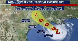
A developing tropical low in the Gulf (Invest97L) could become a tropical depression or storm and approach the Upper Texas Coast by Tuesday, prompting a Tropical Storm Warning from Port Bolivar to Vermilion/Cameron Parish and a flood watch through Wednesday; Monday will be hot and dry, but heavy rain is likely Tuesday with potential street flooding especially east of Houston, along with some gusty offshore winds, though widespread damaging winds aren’t expected.

New York City braces for heavy storms and flood risk through Friday
weather1 month ago

New York City braces for heavy storms and flood risk through Friday

The New York City area is under a flood watch through Friday as heavy rain and thunderstorms threaten the region, with potential downpours of 1 to 2.5 inches per hour and the heaviest rain from 2 p.m. to 8 p.m. Officials have activated the city’s flash flood emergency plan and urged residents to allow extra travel time, avoid floodwaters, prepare for possible evacuations of below-grade spaces, keep devices charged, check on neighbors, and follow official guidance if warnings are issued.

Southern New England Braces for Heavy Rain and Flooding
weather2 months ago

Southern New England Braces for Heavy Rain and Flooding

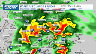
An incoming storm system will bring heavy rain and potential flooding across Southern New England through Wednesday, with a flood watch in effect for parts of Massachusetts and Connecticut. A severe thunderstorm warning was issued for western and central Massachusetts today. The heaviest rain is expected this afternoon and early evening, temperatures near 80 before a cooling trend to the 70s, and winds gusting up to 30 mph, with drier conditions returning by the weekend.

New York City Braces for Up to 7 Inches of Rain from Slow-Moving Storms
weather2 months ago

New York City Braces for Up to 7 Inches of Rain from Slow-Moving Storms

Forecasters warn slow-moving storms could dump 5–7 inches of rain on New York City Tuesday night into Wednesday, with some areas seeing 2–3 inches per hour and a National Weather Service flood watch in effect through Wednesday. The threat includes potentially life-threatening flooding and damaging winds (60–70 mph); NYC Emergency Management has issued a travel advisory and advised residents in basements to move to higher ground. Stay updated via Notify NYC, as unsettled weather could linger into Friday.

Maryland Under Flood Watch as Heavy Thunderstorms Loom on July 6
weather3 months ago

Maryland Under Flood Watch as Heavy Thunderstorms Loom on July 6

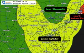
Baltimore area remains under a Flood Watch as slow‑moving, locally heavy thunderstorms are expected July 6, following yesterday’s storms that dumped substantial rainfall and produced strong winds in parts of the region; temperatures linger in the 80s, with a marginal risk of severe weather, and showers are forecast to develop this afternoon and continue through the week.

Big Apple Braces for Monday Flood Threat as Downpours Hit NYC
us-news3 months ago

Big Apple Braces for Monday Flood Threat as Downpours Hit NYC

Forecasters warned New York City to expect multiple rounds of heavy rain and severe flash flooding, with potential rainfall of up to two inches per hour and as much as six inches in the worst spots. The flood watch extends into Tuesday morning, and Mayor Zohran Mamdani activated the city’s Flash Flood Emergency Plan as departments prep catch basins and emergency crews. Residents are urged to limit travel during peak rainfall, check on neighbors, and stay indoors during strong winds and thunderstorms, following a weekend heat wave that left the city scorching.

Gulf disturbance could become 2026’s first named storm, Arthur, bringing heavy rain to Houston
weather3 months ago

Gulf disturbance could become 2026’s first named storm, Arthur, bringing heavy rain to Houston

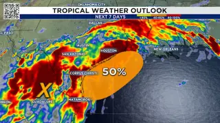
A disturbance over northeastern Mexico has a 50% chance to become a tropical storm in the Gulf, potentially late Tuesday into Wednesday as Arthur—the first named storm of 2026. The bigger risk is prolonged heavy rainfall for Southeast Texas, with a Flood Watch in effect through Thursday and forecast totals of 3–7 inches (locally higher). Rain rates could reach 2–4 inches per hour in bands, creating the potential for flash flooding; stay weather-aware and avoid flooded roads.

Central Texas Braces for Flood-Warning Night as Storms Dump Heavy Rain
weather3 months ago

Central Texas Braces for Flood-Warning Night as Storms Dump Heavy Rain

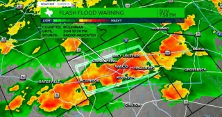
A cold front and stalled boundaries trigger multiple flash flood warnings across Central Texas tonight through Monday, with 3-5 inches of rain possible in slow-moving storms; Waco and surrounding counties (McLennan, Milam, Falls, Bell, Coryell) plus Temple are affected, and a flood watch remains in effect. Cooler temperatures are expected next week, and a Gulf disturbance could bring more rain to the coast later.

West Michigan Braces for Damaging Winds, Hail, and Flooding Overnight
weather5 months ago

West Michigan Braces for Damaging Winds, Hail, and Flooding Overnight

A Weather Alert Day has been issued for West Michigan tonight into early Wednesday due to a developing line of severe storms that could bring damaging winds (60-70 mph), large hail (1-2 inches), and a small tornado risk (about 5%); a flood watch covers nearly all of West Michigan with an additional 2-4 inches of rain possible as storms move quickly from Wisconsin/Illinois toward US-131, with activity peaking around midnight to early morning.