
Central US Heat Dome Drives Record Lows and Northeast Storms
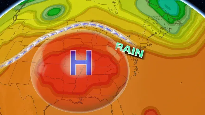
A persistent high-pressure system over the central United States is trapping heat from the Rockies to the East Coast, pushing temperatures above 100 degrees in the South and central US. This heat dome is also disrupting the jet stream, forcing storm systems toward the Northeast and Great Lakes, where heavy rainfall and flooding are expected this week. While daytime highs may not set new records, overnight lows are forecast to be 10 to 20 degrees above average, potentially breaking over 100 record-warm daily lows. The heat is also intensifying temperature contrasts that fuel storm development, with the first major rain threat arriving in the Northeast on Sunday night and continuing through Thursday.
Key points
- A heat dome stretching from the Rockies to the East Coast has pushed temperatures above 100 degrees in Texas, Oklahoma, Kansas, Louisiana, and Arkansas, with some areas feeling like 110 degrees due to humidity.
- Overnight lows are expected to be 10 to 15 degrees above average, with some spots up to 20 degrees above, potentially breaking over 100 record-warm daily lows.
- The high-pressure system is obstructing the jet stream, forcing storms to ride around its edges and move toward the Northeast and Great Lakes.
- The first flooding rain threat begins Sunday afternoon, with heavy rainfall tracking through Pennsylvania, New York, and New Jersey overnight, potentially reaching New York City by 10 or 11 p.m.
- Two to 3 inches of rain are possible in a corridor from the Great Lakes to southern New England, though confidence in the exact path is low.
- Additional rounds of rain and flooding are likely in the Northeast from Tuesday through Thursday, but the exact locations remain uncertain.
Background
This heat dome follows a series of extreme weather events in 2026, including a Southeast heat wave in August that pushed Miami to 100 degrees and a record-breaking heat wave in Southern California in late August. Earlier in the year, a central US heat dome also contributed to severe thunderstorms and flash floods from the Midwest to the Mid-Atlantic, alongside wildfire smoke from Canadian fires. These events highlight a pattern of persistent high-pressure systems driving extreme heat and severe weather across the US.
How outlets are covering it
CNN emphasizes the dual impact of the heat dome on both temperatures and storm formation, noting the disruption of the jet stream and the potential for record-warm lows. Yahoo focuses on the heat's impact on the Mississippi Valley and mid-Atlantic ahead of the Labor Day weekend, but provides less detail on the storm mechanism. Both sources agree on the heat dome's presence and its role in driving extreme conditions, but CNN provides more specific details on the storm track and rainfall amounts.
Why it matters
The heat dome's impact on both temperatures and storm formation highlights the increasing frequency and intensity of extreme weather events driven by climate change. The potential for record-warm lows and heavy rainfall in the Northeast poses risks to infrastructure, public health, and safety, particularly as the region prepares for the fall season. Understanding these patterns is crucial for preparedness and response to future extreme weather events.
What to watch
The heat dome is expected to continue influencing weather patterns in the coming days, with additional rounds of rain and flooding likely in the Northeast from Tuesday through Thursday. Forecasters will monitor the exact path of the storms and the potential for further record-warm lows. The heat may ease slightly in some areas, but the risk of extreme conditions persists.
- A massive heat dome is bringing storms to the Northeast, and causing sweltering temperatures heading into fall CNN
- Heat to focus across Mississippi Valley, mid-Atlantic ahead of Labor Day weekend Yahoo
- Heat Dome Traps Extreme Heat in Southern US and Fuels Storm Risk in the Northeast Межа. Новини України.
- A heat dome is testing North Texas Dallas News
- RAW: HEAT DOME ROASTS CENTRAL U-S, BRINGS STORMS TO NORTH crossroadstoday.com
Want the full story? Read the original reporting
Read on CNN