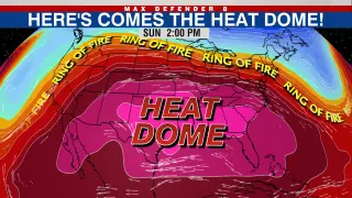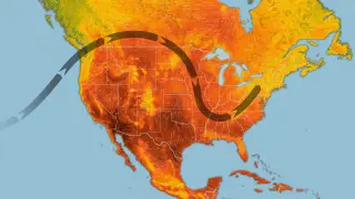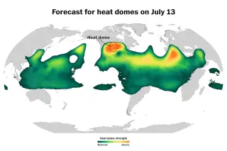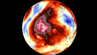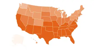
A massive heat dome will blanket most of the continental U.S. for about a week, driving temperatures 15–25°F above normal and yielding dangerous overnight heat, with likely multiple new records and elevated wildfire risk; scientists say the event is amplified by climate change.
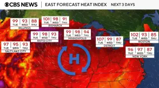
A widespread heat dome is forecast to push temperatures well into the 100s and up to about 110°F across the Intermountain West and northern Plains, threatening tie-or-break records from Salt Lake City to Billings and driving higher fire-weather risk as drought persists; forecasters warn the heat could intensify this weekend, with monsoonal moisture and a moister air mass potentially offering some relief by mid-to-late July.
A massive upper-level heat dome anchored over Western and Southwestern Europe is trapping hot, dry air and driving temperatures well above normal into mid-July, with Iberia and France already recording 40°C-plus days, tropical nights in major cities, worsening soil moisture deficits, and escalating wildfire risk as the pattern expands north and east toward the UK, Ireland, and central Europe.
A scorching heat wave sweeping the eastern and central United States has killed more than 20 people in the past week, with New Jersey reporting 25 heat-related deaths since July 2. Victims ranged from their 30s to 80s, many found in unair conditioned homes or outdoors. Other incidents include a 74-year-old man in Mississippi and numerous heat illnesses at a Pennsylvania event and in Washington, DC. Officials warn the death toll is preliminary as the East eases slightly with the heat dome shifting, while a new dome may push extreme heat to the West and trigger severe storms through July 7.
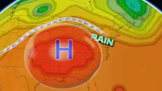
A dangerous heatwave is building across the U.S. East Coast, with temperatures around 100F (38C) and heat indices up to 115F for several days over the 4 July weekend, driven by a persistent high-pressure 'heat dome' and drought; the heat threatens outdoor events including President Trump’s Fourth of July celebration and World Cup watch parties, prompting officials to urge people to stay indoors, hydrate, and seek cooling.
Forecasters warn a dangerous heat dome will push the eastern U.S. into record-breaking heat through the Fourth of July weekend, with highs mostly in the mid‑90s to low‑100s and heat indices of 100–115°F in places. Nearly 200 million Americans are under heat advisories as several all-time records are expected to be challenged on the East Coast. The West remains cooler thanks to a persistent trough, while fire danger rises in parts of Utah, Colorado and New Mexico. Stay hydrated, seek air conditioning, limit outdoor exposure, and check on vulnerable neighbors.
A heat dome will push temperatures into the 90s and 100s across southern New England this week, triggering an Extreme Heat Warning from Wednesday through Saturday (the Fourth of July) for parts of Massachusetts and Rhode Island. The heat index could reach around 109°F due to high dew points, with conditions hottest Thursday; beaches may stay cooler near the coast, and residents should take heat-safety precautions.
A dangerous heat wave fueled by a heat dome will sweep central to eastern U.S. this week, with daytime highs in the 90s to low 100s and humidity pushing heat indices to 100–110°F (locally up to 115°F). About 90 million people are under extreme heat alerts and up to 230 million could be exposed, with little overnight relief and the possibility of record highs; the heat dome is forecast to linger into the Fourth of July weekend, gradually easing from west to east afterward. Stay hydrated, stay cool, and check on vulnerable neighbors.
A stagnant heat dome will drive a broad heat wave across the eastern U.S. during the Fourth of July week, with temperatures forecast to reach the upper 90s to around 100°F in New England—Boston included—while humidity raises heat indices. Monday and Tuesday look milder, but by midweek the heat ramps up and is expected to peak by the weekend, prompting warnings and cautions to stay cool and hydrated.
Forecasters warn a dangerous heat dome will push the central and eastern United States into hot conditions through the Fourth of July weekend, with temperatures climbing from the 90s into the low 100s and in some places potentially reaching triple digits; daily records could be broken in Washington, D.C., Philadelphia, and New York City, as the heat persists across the region.
Forecasters expect a heat dome to lock over the eastern half of the United States next week, driving heat indices to 100–110°F (with some spots up to 115°F) and producing oppressive humidity with little overnight relief. Major cities including Chicago, Detroit, St. Louis, Dallas and Nashville could see their hottest days of the year as millions face Level 3–4 extreme heat risk while the jet stream shifts and traps hot air; the West cools somewhat in contrast. Utah faces extreme fire weather with rare “particularly dangerous” red-flag warnings and gusts up to 50 mph as ongoing fires burn nearby. The heat is projected to spread into the Northeast by midweek, and a potential westward shift toward the Plains could arrive around the Fourth of July weekend.
Europe is grappling with its second major heat wave in two months, with temperatures topping 100°F across several countries. France banned public alcohol consumption and closed more than 800 schools as the heat threatens the hottest day on record, while the UK braces for possible new June heat records. The heat dome, amplified by El Niño, underscores rising extreme heat risks linked to climate change and a warming planet.
A giant heat dome over Western Europe, driven by a strong upper-level ridge from Northwest Africa, is fueling an early and long-lasting heatwave across Iberia, France, and beyond. Dry soils from a record-breaking May amplify warming, with Iberia nudging toward 45 °C and Paris-area highs in the upper 30s to low 40s; the pattern is expected to persist through much of June, raising drought, wildfire, and heat-related health risks for vulnerable populations. Forecasters from ECMWF and GFS project near-record upper-atmosphere heights that will keep the heat plumes expanding north and east, though exact impacts will vary by region as the ridge remains parked over Western Europe.
The French Open is confronting dangerous heat, with officials using the wet bulb globe temperature (WBGT)—a metric that combines temperature, humidity, solar radiation, and wind—to gauge risk and justify shade breaks, cooling, and potential delays. While elite athletes can tolerate higher heat, WBGT thresholds around the mid-80s°F mark signal growing health risks, and scientists warn that climate trends could push these extreme conditions into the norm in hot regions.
A May heatwave, driven by a heat dome and intensified by human-caused climate breakdown, sent temperatures well above seasonal norms in Madrid, Paris, London, Dublin, and Berlin. Tourists and locals sought shade and water, with air conditioning in short supply in some areas, while residents and visitors alike note rising risks and the need to adapt to increasingly extreme urban heat.