
Offshore Nor’easter Threatens East Coast with Wind and Flooding, but Mass. Remains on Fringe
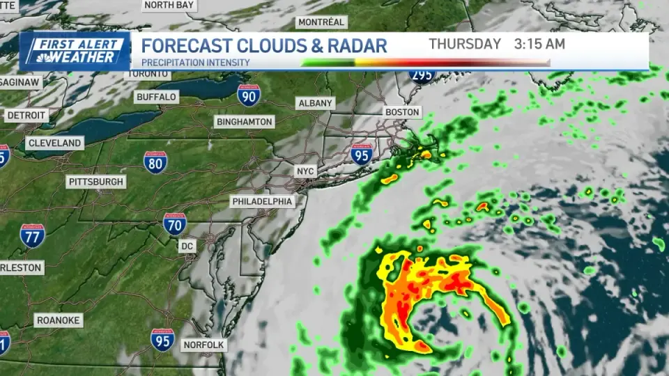
A powerful nor'easter is currently churning in the Western Atlantic, posing risks of coastal flooding and strong winds to the easternmost US coastline. While the National Hurricane Center assigns a 40% chance of the system developing into a subtropical storm named Josephine, it is expected to remain far offshore. Massachusetts is forecast to experience only marginal impacts, including wind gusts up to 40 mph and potential showers on the Cape, while the heaviest rain and flooding are concentrated from New Jersey to the Outer Banks.
Key points
- The National Hurricane Center has issued a 40% probability that the current offshore system will develop into a subtropical storm within the next few days.
- If the system develops, it will be named Josephine, though it is expected to intensify only as it moves eastward away from the US coast.
- Flood advisories are in effect from the Jersey Shore to the Outer Banks, warning of 1 to 2 feet of inundation caused by onshore winds.
- Wind forecasts for the region include 44 mph gusts in Nantucket, 39 mph in Cape Hatteras, and 32 mph in Virginia Beach.
- Massachusetts is positioned on the storm's fringe, with temperatures fluctuating between the low 50s and low 60s and rough seas persisting through the week.
Background
This event follows a pattern of significant nor'easter impacts in the region earlier in the fall. In late September, a slow-moving storm delivered over 8 inches of rain to parts of the South Shore and more than 5 inches to Boston. Prior to that, in mid-September, forecasters warned of a potential nor'easter with 50 mph winds and coastal flooding, though model disagreements on the track led to varying severity assessments. The current system represents a new development, distinct from those earlier events, though it shares the characteristic of affecting the easternmost parts of the state.
How outlets are covering it
NBC Boston and NBC News provide consistent but differently scoped views of the storm's impact. NBC Boston, focusing on Massachusetts, emphasizes that the state is on the 'very fringe' of the storm, predicting only occasional clouds, wind gusts to 40 mph, and uncertain rainfall limited to the Cape and Islands. It notes that the storm may strengthen as a cold front pushes it east into the Maritimes. In contrast, NBC News provides a broader East Coast perspective, highlighting that the storm is 'churning' and bringing 'heavy rain, flooding and strong winds' to the easternmost parts of the country. While both outlets agree on the 40% chance of subtropical development and the offshore nature of the storm, NBC News places greater emphasis on the immediate flood advisories and wind impacts along the Mid-Atlantic and Outer Banks, whereas NBC Boston focuses on the marginal weather conditions expected in New England.
Why it matters
The storm's offshore track limits direct damage to major population centers but poses significant risks to coastal infrastructure and maritime activities. The potential for the system to become a named subtropical storm, Josephine, indicates a level of organization that could sustain high winds and rough seas for an extended period. For Massachusetts, the primary concerns are localized wind gusts and potential showers on the Cape, while the broader East Coast faces more immediate threats of coastal flooding and beach erosion. The uncertainty in the storm's track and intensity requires continued monitoring, particularly for the potential for the system to strengthen as it moves eastward.
What to watch
Forecasters expect the storm to continue moving eastward, potentially strengthening as it interacts with a cold front. If it develops into a subtropical storm, it will likely do so as it moves away from the US coast. For Massachusetts, wind gusts are expected to peak tomorrow before dropping off Thursday morning, with a possible resurgence of stronger winds Thursday night and early Friday. Rainfall remains uncertain, with the best chance for wet weather on the Cape and Islands on Thursday. Temperatures are expected to remain cool, with the low 50s tomorrow and the low 60s Thursday, before colder conditions set in for the weekend.
- There's a nor'easter offshore today. How will it impact Mass. this week? NBC Boston
- Powerful nor'easter shows possible tropical development as it hits Carolinas, Mid-Atlantic with dangerous surf FOX Weather
- Windy Wednesday expected in Massachusetts Yahoo
- Outer Banks storm intensifies, NC12 closed WAVY.com
- Offshore nor’easter creating high surf and coastal flooding along the East Coast NBC News
Want the full story? Read the original reporting
Read on NBC Boston