
Uncertain East Coast storm threatens Thanksgiving travel with heavy rain and wind
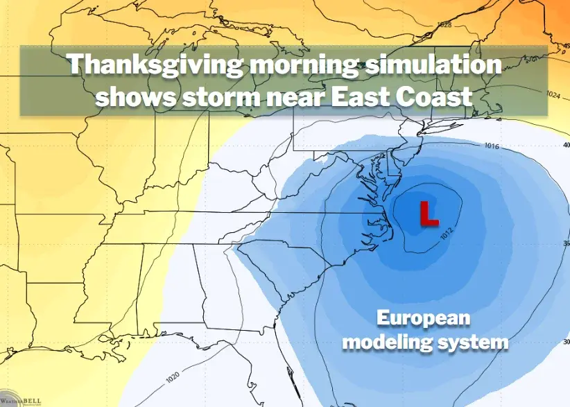
A developing coastal low-pressure system, potentially named Kyle, is expected to move up the East Coast from Florida, impacting travel and weather from late Sunday through Thanksgiving Day. While the exact track remains uncertain, forecasters warn of heavy rain, strong winds, and coastal flooding across the Mid-Atlantic and Northeast. The system may intensify into a tropical or subtropical storm, with rain totals ranging from 1 to 5 inches depending on its path. This event follows a dry month in the DC area and coincides with a strong El Niño, which is enhancing the subtropical jet stream. Travelers are advised to monitor forecasts closely, as conditions could shift rapidly in the coming days.
Key points
- A coastal storm is expected to form off Florida on Friday and move north, potentially impacting the East Coast from Sunday into Thanksgiving Day.
- The storm's track is uncertain, with models showing a range from a glancing blow to a direct hit, affecting rain and wind totals significantly.
- Rain totals could range from 1 to 5 inches in affected areas, with wind gusts reaching 30 to 40 mph if the storm tracks close to the coast.
- The National Hurricane Center gives the system a 60% chance of tropical or subtropical development over the next seven days.
- El Niño is strengthening the subtropical jet stream, which may fuel an active storm track and bring more moisture to the region.
Background
This storm follows a period of unusually mild and dry weather in the Mid-Atlantic, with only 0.17 inches of rain recorded in DC over the past month. The current El Niño event, described as a 'super El Niño,' has already driven record waves and coastal flooding along the California coast, highlighting its global impact on weather patterns. A previous nor'easter in October brought wind and coastal flooding to the East Coast, but this new system is distinct and may bring more significant precipitation.
How outlets are covering it
Capital Weather emphasizes the uncertainty of the storm's track, noting that impacts will depend heavily on whether it hugs the coast or stays offshore. FOX 5 New York highlights the potential for heavy rain and wind in the NYC area, with rain totals ranging from 0.25 to 3 inches, and advises that Saturday is a better travel day than Sunday. CT Insider focuses on the risk of heavy rain and flooding in Connecticut, with some models showing 3 to 5 inches of rain, while the Baltimore Sun notes the potential for the system to be named Kyle if it develops into a storm. All sources agree that the exact track and intensity remain uncertain, but they differ in their emphasis on the potential for tropical development and the specific impacts on their respective regions.
Why it matters
The potential storm could disrupt Thanksgiving travel across the East Coast, with heavy rain, strong winds, and coastal flooding posing risks to roads, airports, and coastal communities. The uncertainty of the storm's track means that travelers and residents need to stay informed and prepared for changing conditions. The event also highlights the influence of El Niño on weather patterns, which may lead to more active storm tracks in the coming weeks.
What to watch
Forecasters expect the storm to take shape off Florida on Friday, with the picture becoming clearer as it develops. Travelers should monitor forecasts closely and consider adjusting their plans if the storm tracks closer to the coast. The potential for a third storm over the holiday weekend is also being monitored, though confidence in this scenario is low.
- Coastal storm could disrupt Thanksgiving travel along East Coast Capital Weather
- Coastal storm could soak NYC area, parts of NJ Sunday into Monday FOX 5 New York
- Coastal storm shifts west. Connecticut could see heavy rain and gusty winds CT Insider
- A possible coastal storm could impact Maryland. What to know. Baltimore Sun
- N.J. weather: Potential tropical storm could dump 2 to 3 inches of rain on state, but track remains unclear NJ.com
Want the full story? Read the original reporting
Read on Capital Weather