
Tropical Storm Edouard Nears Texas Coast with Rain as Primary Threat
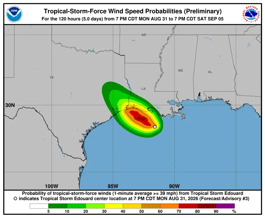
Tropical Storm Edouard is approaching the Texas coast with 40 mph winds, expected to make landfall near the Texas-Louisiana border on Tuesday. While the storm may strengthen to hurricane status, the primary risk for the Houston area is heavy rainfall and localized flooding rather than widespread wind damage or power outages.
Key points
- Edouard is moving west-northwest at 7 mph with sustained winds of 40 mph as of Monday evening.
- Landfall is forecast for Tuesday midday near the Texas-Louisiana border, potentially reaching Category 1 hurricane strength.
- The National Hurricane Center has issued a Hurricane Watch from High Island, Texas, to Cameron, Louisiana.
- A Flood Watch covers Southeast Texas through Wednesday morning, with 2 to 5 inches of rain expected east of Interstate 45.
- Several Houston-area school districts, including Dayton ISD and Crosby ISD, have canceled classes for Tuesday.
Background
This development follows earlier forecasts from August 31, 2026, which identified a developing tropical low in the Gulf as a potential threat to the Upper Texas Coast. Prior reports indicated that while Monday would remain dry, heavy rain and street flooding were anticipated for Tuesday, particularly east of Houston. The formation of Edouard confirms these earlier warnings, transitioning the system from a potential tropical cyclone to an active storm.
How outlets are covering it
Space City Weather emphasizes that while impacts are inevitable, they are unlikely to be severe for most Houston residents, advising against excessive preparations like hoarding supplies. They note that wind gusts will generally remain in the 20s to 30s mph, with no widespread power outages expected. In contrast, FOX 26 Houston highlights the official warnings, including a Hurricane Watch and Storm Surge Warning, and focuses on the potential for isolated rainfall totals of 6 to 9 inches in specific spots east of I-45. While both sources agree on the rain-centric threat, Space City Weather downplays the severity for the metro area, whereas FOX 26 details the specific areas at risk for stronger winds and the immediate school closures.
Why it matters
The storm poses a significant risk of flash flooding and street closures in Southeast Texas, particularly east of Interstate 45. Residents must monitor local forecasts and avoid driving through flooded areas. The potential for hurricane-strength winds near the coast necessitates preparedness for coastal communities, even if the inland impact remains moderate.
What to watch
Forecasters expect Edouard to move northwest after landfall, potentially passing near Conroe or Huntsville on Tuesday night before dissipating south of Dallas. The next major update from local weather services is scheduled for no later than 7 a.m. CT on Tuesday. Residents should continue to monitor official channels for updates on rainfall totals and any changes to the storm's track.
- Setting expectations for Tropical Storm Edouard and the greater Houston area Space City Weather
- Tropical storm Edouard a flood, wind threat in Texas, Louisiana The Weather Channel
- Tropical Storm Edouard forms in Gulf, on track for Texas FOX 26 Houston
- Houston-area school closings: Districts announce closures, delays due to Tropical Storm Edouard KHOU
- Gulf disturbance becomes better organized, now has 70% chance of developing near Louisiana WWLTV.com
Want the full story? Read the original reporting
Read on Space City Weather