
Atmospheric River Targets Southern California with Flood Watches and Heavy Rain
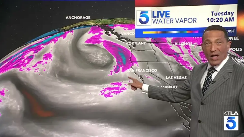
A powerful atmospheric river is bringing heavy rain and flood risks to Southern California, with Los Angeles County under a flood watch for potential inch-per-hour rainfall. Mountain areas may see up to 5 inches of rain, while coastal regions face high surf and debris flow risks in burn scars. The storm is expected to clear by the weekend, bringing drier, cooler weather.
Key points
- Los Angeles County is under a flood watch starting Thursday, with a 50% chance of an inch of rain per hour, especially in mountain areas.
- Most of Los Angeles County is forecast to receive 1 to 3 inches of rain, while mountain regions could see 3 to 5 inches.
- The National Weather Service warns of significant impacts, including flooding, strong winds, and coastal hazards like large surf and high tides.
- Santa Barbara and San Luis Obispo counties are also under flood watches, with risks of debris flows in burn scars from recent fires.
- The storm is described as a 'quick hitter,' with sunny, mid-60s weather expected by the weekend.
Background
This event follows a series of atmospheric rivers earlier in November 2026, including one that caused record floods in Arizona and Colorado on November 1. The current storm is part of a broader El Niño pattern, which has already brought massive waves and coastal damage to California. Earlier this week, waves pulled pilings from the Avila Pier and forced closures at several piers, highlighting the ongoing coastal risks.
How outlets are covering it
KTLA emphasizes the intensity of rainfall in Los Angeles County, noting the potential for an inch of rain per hour and the risk of flooding and wind-related issues. The San Luis Obispo Tribune highlights the broader impact on the Central Coast, including flash flood risks in Big Sur burn scars and potential highway closures. Noozhawk focuses on Santa Barbara County, detailing rain rates, thunderstorm chances, and the risk of debris flows in burn areas. The Los Angeles Daily News provides specific details on the flood watch for the Santa Susana and San Gabriel Mountains, warning of rockslides and mudslides in recent burn scars. All sources agree on the severity of the storm but differ in their regional focus and specific risks.
Why it matters
The atmospheric river poses significant risks of flooding, debris flows, and coastal hazards across Southern California. Residents in low-lying and flood-prone areas should prepare for potential road closures and emergency situations. The storm also highlights the ongoing impacts of El Niño, which may lead to a wetter winter and increased risks of extreme weather events.
What to watch
The storm is expected to clear by the weekend, bringing drier, cooler weather with highs in the mid-60s. Residents should monitor local forecasts and be prepared for potential flooding and debris flows, especially in burn scars and low-lying areas. Coastal areas should remain cautious of high surf and rip currents.
- Atmospheric river could drop an inch of rain per hour across Los Angeles County, flood watch issued KTLA
- Flood watch issued for SLO County, people urged to avoid Big Sur as storm approaches San Luis Obispo Tribune
- Rain, Thunderstorms Forecasted in Santa Barbara County Throughout the Week Noozhawk
- Flood watch affecting Western Santa Monica Mountains Recreational area and Santa Susana Mountains Thursday Los Angeles Daily News
- Flood Watch Wednesday into Thursday, rain heavy at times, possible thunder KSBY News
Want the full story? Read the original reporting
Read on KTLA