
Tropical Depression Five strengthens into Storm Edouard, targeting upper Texas coast with heavy rain risks
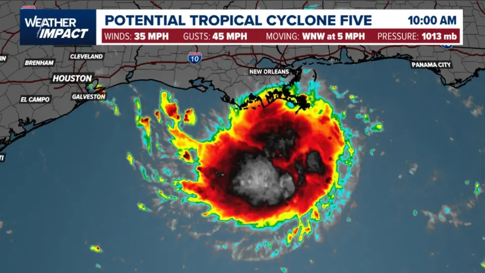
Tropical Depression Five has formed in the northern Gulf of Mexico and is forecast to strengthen into Tropical Storm Edouard before making landfall near High Island, Texas, on Tuesday. The National Hurricane Center has issued tropical storm warnings for the upper Texas and southwestern Louisiana coasts. While wind impacts are expected to be moderate, the primary hazard is heavy rainfall, with forecasts predicting 3 to 6 inches of rain across the upper Texas coast and potential flash flooding in urban areas. The system is moving west-northwest at 5 mph and is expected to bring significant moisture to the Houston region, prompting local flood alerts.
Key points
- Tropical Depression Five is located approximately 130 miles south of Morgan City, Louisiana, and 230 miles southeast of Port Arthur, Texas.
- The system has maximum sustained winds of 35 mph and is moving west-northwest at 5 mph.
- A tropical storm warning is in effect from Port Bolivar, Texas, to the Vermilion and Cameron Parish line in Louisiana.
- Landfall is expected on Tuesday between High Island, Texas, and Cameron, Louisiana.
- Rainfall totals of 3 to 6 inches are forecast for the upper Texas coast, with isolated amounts up to 9 inches.
- Storm surge of 1 to 3 feet is possible if peak surge coincides with high tide.
Background
This system is the fifth tropical cyclone of the 2026 Atlantic season. Earlier this month, Tropical Storm Bertha made landfall in Louisiana, bringing wind and surge warnings to the Gulf Coast. The current system, Edouard, is developing as the hurricane season approaches its historical peak.
How outlets are covering it
12NewsNow and WDSU report that the National Hurricane Center has issued tropical storm warnings for the upper Texas and southwestern Louisiana coasts, with landfall expected on Tuesday. The Weather Channel notes that the system could strengthen into Tropical Storm Edouard and soak east Texas. Space City Weather emphasizes the rainfall risk for Houston, issuing a Stage 2 flood alert for areas east of Interstate 45, while noting that wind impacts in the Houston region are likely to be limited to gusts of 30 to 40 mph. All sources agree on the track and the potential for heavy rain, but Space City Weather provides more specific local flood alerts for the Houston area.
Why it matters
The system poses significant risks of coastal flooding, heavy rainfall, and flash flooding for the upper Texas and southwestern Louisiana coasts. Residents in the warning area are advised to complete necessary preparations before conditions deteriorate. The heavy rainfall could lead to significant flooding in urban areas and low-lying drainage basins, potentially impacting transportation and infrastructure.
What to watch
The National Hurricane Center expects the system to strengthen into a tropical storm by tonight and to make landfall on Tuesday. Residents in the warning area should monitor updates from local authorities and the National Hurricane Center. Space City Weather plans to provide another update by or before 10 pm CT on Monday.
- Tropical Storm Warning issued for Upper Texas and Southwest Louisiana | Forecast, cone and models 12newsnow.com
- Tropical storm warning issued for Louisiana, Texas coasts ahead of soaking, potential Edouard The Weather Channel
- Tropical Depression Five, churns towards Texas, SW Louisiana; What New Orleans can expect WDSU
- Tropical Depression forms in northern Gulf, with heavy rain and flood risks inbound for Houston Space City Weather
- Heavy rain and flooding possible with tropical system Tuesday and Wednesday KLTV.com
Want the full story? Read the original reporting
Read on 12newsnow.com