
Hurricane Isaias Remnants Bring Rain, Gale Warnings to Mid-Atlantic Coast
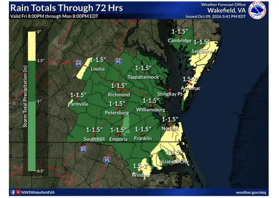
The remnants of Hurricane Isaias are moving inland, bringing rain, gusty winds, and hazardous marine conditions to the Mid-Atlantic. The National Weather Service has issued a Slight Risk for severe weather in Virginia’s Eastern Shore and Gale Warnings for parts of the Chesapeake Bay and Atlantic coast. While rainfall totals are moderate, ranging from 1 to 2 inches, localized flooding and strong winds are expected through Sunday. Conditions are forecast to improve by Monday, with dry weather returning by Tuesday.
Key points
- Rain is expected to spread across the region Saturday night, continuing into Sunday with totals of 1 to 2 inches.
- The National Weather Service has placed Virginia’s Eastern Shore under a Slight Risk for severe weather, including damaging winds and possible tornadoes.
- Gale Warnings are in effect for the mouth of the Chesapeake Bay and Atlantic waters from Parramore Island to Cape Charles.
- Wind gusts of 25 to 35 mph are forecast for coastal areas, with stronger gusts possible in severe thunderstorms.
- Conditions are expected to ease Sunday evening, with dry weather returning by Tuesday.
Background
This event follows a pattern of recent tropical systems affecting the region. In September, a nor'easter brought intermittent showers and breezy conditions to the DC area, with coastal flooding and gusty winds. Earlier in the month, the remnants of Tropical Storms Edouard and Dolly brought heavy rain and flood risks to Texas and Florida, respectively. The current system, Isaias, is the latest in a series of post-tropical disturbances impacting the Mid-Atlantic.
How outlets are covering it
Shore Daily News emphasizes the marine hazards and severe weather risk for Virginia’s Eastern Shore, highlighting Gale Warnings and the Slight Risk designation. NBC4 Washington focuses on the broader impact on D.C., Maryland, and Northern Virginia, noting a flood watch for parts of Northern Virginia and an isolated tornado risk. WTOP News provides a detailed forecast for the D.C. region, highlighting the potential for localized flash flooding and the uncertainty of the heaviest rainfall. All sources agree on the moderate to heavy rain and gusty winds, but differ in their emphasis on specific regional impacts and risks.
Why it matters
The remnants of Hurricane Isaias pose a significant risk of localized flooding, hazardous marine conditions, and severe weather in the Mid-Atlantic. Residents and mariners should monitor forecasts and prepare for potential disruptions, including road flooding and dangerous water conditions. The event underscores the ongoing impact of post-tropical systems on the region, following a series of similar disturbances in recent months.
What to watch
Residents should monitor subsequent forecasts and any severe-weather alerts issued Sunday. Conditions are expected to ease Sunday evening, with dry weather returning by Tuesday. Mariners should be cautious of rough seas and strong winds, particularly in the Chesapeake Bay and Atlantic coastal waters.
- Isaias remnants expected to bring rain, gusty winds and rough waters to Eastern Shore Shore Daily News
- LIVE | Tracking Hurricane Isaias: Here's the latest forecast, model, and flood threat for the Mid-South localmemphis.com
- Storm Team4: Rain from Isaias expected late Saturday, all day Sunday NBC4 Washington
- WEATHER ALERT DAY SUNDAY: Tracking Heavy Rain From Isaias In Maryland WBFF
- Damp days ahead as hurricane remnants head toward DC region WTOP News
Want the full story? Read the original reporting
Read on Shore Daily News