
Hurricane Polo remnants trigger widespread flooding risks across Texas and Midwest
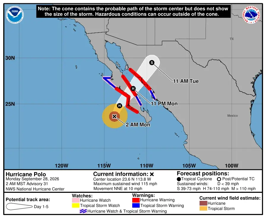
The remnants of Hurricane Polo are moving inland from the Pacific, bringing significant rainfall and flood risks to Texas, New Mexico, and the Midwest. Central Texas faces the highest threat, with potential totals of 4 to 12 inches, while Houston expects 1 to 4 inches later in the week. Cooler temperatures are also forecast across affected regions.
Key points
- Hurricane Polo, a Category 5 storm, is making landfall in Baja California and moving northeast toward the US.
- Central Texas and North Texas are under moderate flash flood risk, with rain totals potentially reaching 12 inches in isolated areas.
- Houston expects 1 to 4 inches of rain by Sunday, with temperatures dropping into the 80s.
- El Paso and parts of New Mexico are under a flood watch through Wednesday, with rain chances reaching 95% on Tuesday.
- Chicago and other Midwest cities may see several days of rain and cooler temperatures starting Wednesday.
Background
This event follows recent severe weather in Texas, including Tropical Storm Edouard in early September, which caused significant flooding in southeast Texas. The current system highlights the recurring impact of Pacific hurricane remnants on the southern US.
How outlets are covering it
Space City Weather emphasizes the severe flood risk in central Texas, noting that some areas could receive up to 12 inches of rain. FOX 4 News Dallas-Fort Worth focuses on the relief from prolonged heat and drought, highlighting that while rain is needed, dry soils may lead to localized flash flooding. El Paso Times details the specific timeline for El Paso, noting a 95% chance of rain on Tuesday and a moderate risk of excessive rainfall. NBC 5 Chicago highlights the broader impact on the Midwest, predicting several days of rain and cooler temperatures in the Chicago area starting Wednesday. While all sources agree on the widespread nature of the rain, they differ in their emphasis on local impacts and flood risks.
Why it matters
The widespread rainfall and flood risks from Hurricane Polo's remnants could cause significant disruptions, including travel delays, property damage, and potential loss of life. The event also highlights the ongoing challenges of climate change and the increasing frequency of severe weather events in the US.
What to watch
Forecasters will continue to monitor the path of Hurricane Polo's remnants and update flood risk assessments. Residents in affected areas should stay informed through local weather alerts and prepare for potential disruptions. Cooler temperatures are expected to follow the rain in many regions.
- Heavy rains are inbound to Texas this week, with flooding likely in central parts of the state Space City Weather
- Dallas weather: Sept. 28 morning forecast FOX 4 News Dallas-Fort Worth
- Is it going to rain today in El Paso? See Hurricane Polo storm timeline elpasotimes.com
- Remnants of Hurricane Polo could impact Chicago weather this week NBC 5 Chicago
- Omaha weather: Surge of tropical moisture will bring widespread rain to close out September KETV
Want the full story? Read the original reporting
Read on Space City Weather