
Record El Niño Signals Milder Ohio Winter, Though Snow Risks Persist
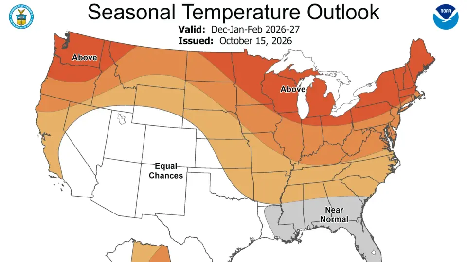
NOAA’s 2026-2027 winter outlook projects above-average temperatures for Ohio due to a historic El Niño. While seasonal snow cover may decrease, experts warn that individual severe storms and cold snaps remain possible.
Key points
- NOAA released its winter outlook on Oct. 15, favoring warmer-than-average temperatures across the Midwest, including Ohio.
- The 2026 El Niño is projected to be the strongest since 1950, with an 83% probability of peak intensity.
- Precipitation forecasts for the Ohio Valley remain uncertain, though snowpack is likely to be below normal.
- Lake-effect snow near Lake Erie may be reduced due to warmer air, but individual storms can still produce heavy accumulation.
- Residents are advised to prepare for potential major snowstorms despite the milder seasonal average.
Background
This development follows earlier reports of a record-strength El Niño influencing global weather patterns. Previous coverage noted that while the southern U.S. may face wetter conditions, the northern tier, including the Great Lakes region, is trending toward milder temperatures. The current event is part of a broader climate shift observed in 2026, with NASA satellites tracking significant changes in Pacific sea surface temperatures and ocean color.
How outlets are covering it
The Columbus Dispatch emphasizes the uncertainty in precipitation forecasts for Ohio, noting that while the seasonal average is warmer, individual storms can still bring heavy snow. KWQC highlights historical data, pointing out that strong El Niño winters in the Quad Cities area have consistently resulted in below-average snowfall, such as the 2015-2016 season. NASA Science focuses on the global scale of the event, describing it as a historic phenomenon that is altering ocean currents and marine ecosystems, with sea surface temperatures in the eastern Pacific already 3 degrees Fahrenheit above average. While all sources agree on the warming trend, they differ in emphasis: local outlets focus on snow totals and storm risks, while NASA highlights the broader oceanic and atmospheric shifts.
Why it matters
The forecast impacts winter planning for Ohio residents, including transportation, energy usage, and emergency preparedness. A milder winter could reduce heating costs but may also lead to complacency regarding severe weather risks. Additionally, the El Niño’s global effects, such as changes in sea level and marine food webs, have long-term implications for climate stability and coastal communities.
What to watch
NOAA will continue to monitor the El Niño’s progression, with peak intensity expected later in the winter. Residents should watch for updated forecasts as individual storm systems develop. NASA and other agencies will track the event’s impact on ocean temperatures and global weather patterns through 2027.
- Will Ohio have a mild or brutal winter? Latest NOAA forecast amid El Niño The Columbus Dispatch
- New Maps Forecast Winter 26/27 as El Niño Strengthens POWDER Magazine
- NASA Satellites Observe Historic 2026 El Niño NASA Science (.gov)
- Newly released winter outlook favors milder winter as super El Nino builds KWQC
- 70 degrees on Christmas Eve? How past Super El Niños impacted Yuletide The Weather Channel
Want the full story? Read the original reporting
Read on The Columbus Dispatch