
Curiosity's Unbalanced Dawn Photo Reveals Mystery Cliffs on Mount Sharp
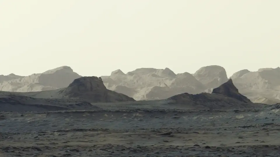
NASA's Curiosity rover has released a new panoramic image of a Martian sunrise, offering the most detailed view yet of wind-carved cliffs known as yardangs. Captured on August 11, 2026, the image was processed without standard white balancing to preserve the early morning light. The photo highlights a mysterious geological layer on Mount Sharp that scientists hope to reach by 2027 to determine its origin.
Key points
- The panorama was stitched from six images taken by Curiosity's Mastcam on August 11, 2026, at 8:30 a.m. local Mars time.
- NASA processed the images without white balancing to maintain the natural appearance of the dawn, revealing blue hues in the foreground.
- The yardang layer extends approximately 10 miles (16 kilometers) across the northwestern reaches of Mount Sharp.
- Curiosity recently reached an elevation of 1 kilometer (0.6 miles), the highest point any rover has climbed on Mars.
- Scientists plan to reach the base of the yardangs in 2027 to collect data and analyze how the cliffs formed.
Background
Curiosity has been exploring Gale Crater since its landing in August 2012, climbing Mount Sharp to study sedimentary layers that record Mars' ancient history. Previous missions have identified signs of past water, including dried-up lakes and salty mineral deposits. This new imagery builds on earlier discoveries of organic compounds and clay-rich mudstones, contributing to the ongoing search for evidence of ancient habitability on Mars.
How outlets are covering it
USA TODAY emphasizes the visual quality of the image, noting it is the most detailed view of Martian cliffs ever captured. NASA's Jet Propulsion Laboratory (JPL) focuses on the scientific significance, highlighting the mystery of the yardang layer's formation and the rover's recent elevation milestone. BBC Sky at Night Magazine contextualizes the image within the broader history of water on Mars, explaining how wind erosion of dried mineral deposits may have created the cliffs. All sources agree on the technical details of the capture and processing but differ in emphasis: USA TODAY highlights the aesthetic, JPL the scientific unknowns, and BBC the geological history.
Why it matters
This image provides a new perspective on the geological history of Mars, potentially offering clues about ancient volcanic activity or wind erosion processes. As Curiosity approaches the yardang layer, future data could help resolve long-standing questions about the formation of these unique features and the planet's past environmental conditions.
What to watch
Curiosity is expected to continue its ascent of Mount Sharp, driving through sulfate and carbonate layers enriched with signs of ancient drying. Scientists aim to reach the base of the yardangs in 2027, where the rover will use its robotic arm to collect samples and data to determine the origin of the mysterious cliffs.
- NASA photo of Mars dawn reveals cliffs in unprecedented detail USA Today
- NASA’s Curiosity Rover Catches Stunning Martian Dawn NASA Jet Propulsion Laboratory (JPL) (.gov)
- Good morning Mars! New image shows crisp view of morning light over distant Martian mountains. This is what it would be like to walk on the Red Planet BBC Sky at Night Magazine
- NASA rover takes striking image of dawn's early light on Mars Reuters
- Curiosity rover captures unprecedented view of Mars cliffs KTLA
Want the full story? Read the original reporting
Read on USA Today