
NASA-ISRO Satellite Captures First-Ever Time-Lapse of Krasheninnikov’s Decade-Long Lava Flow
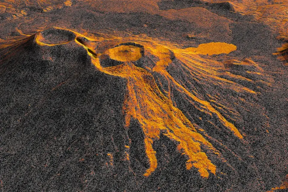
The NASA-ISRO Synthetic Aperture Radar (NISAR) satellite has produced a time-lapse video documenting the ongoing lava flow from Krasheninnikov volcano in Russia’s Kamchatka Peninsula. The eruption, triggered by an 8.8-magnitude earthquake on July 30, 2025, marked the first activity for the twin volcanoes in nearly 500 years. NISAR, launched on the same date as the earthquake, began monitoring the site in December 2025, capturing 17 high-resolution images through August 2026. The footage reveals lava filling an inner caldera, overflowing into a wider crater, and spreading eastward in a fan shape. This demonstrates NISAR’s capability to monitor remote natural hazards with high precision, offering a new tool for global volcanic surveillance.
Key points
- Krasheninnikov, a pair of volcanoes on Russia’s Kamchatka Peninsula, erupted for the first time since 1550 following an 8.8-magnitude earthquake on July 30, 2025.
- The NISAR satellite, a joint NASA-Indian Space Research Organisation (ISRO) mission, launched on July 30, 2025, and began operational monitoring of the site on December 25, 2025.
- NISAR orbits at 747 kilometers (464 miles) altitude, passing over the volcano twice every 12 days to capture Synthetic Aperture Radar (SAR) images.
- A time-lapse video compiled from 17 images taken through August 2026 shows lava spreading eastward from the northern crater, filling an inner caldera before overflowing into a wider crater.
- NISAR features two complementary SAR systems: NASA’s L-band (24cm) and ISRO’s S-band (9.4cm), allowing it to map both ground surfaces and tree canopies with high resolution.
- The satellite’s 12-meter wide radar antenna reflector is the largest NASA has ever launched, enabling detailed imaging of Earth’s land surface at resolutions of approximately 10 meters.
Background
While our archive highlights recent developments in NASA’s commercial partnerships and satellite technology reuse, such as the Starfish Space debris inspection mission and the Nancy Grace Roman Space Telescope, the Krasheninnikov event underscores the critical role of dedicated Earth-observation missions. Unlike the commercial servicing or dark energy research missions noted in previous coverage, NISAR is specifically designed for high-frequency, high-resolution monitoring of Earth’s surface, filling a gap in global hazard surveillance that ground-based instruments cannot cover in remote regions like Kamchatka.
How outlets are covering it
All sources agree on the core facts: the eruption was triggered by the July 30, 2025 earthquake, and NISAR has been monitoring the lava flow since December 2025. NASA and tovima.com emphasize the technical capabilities of NISAR, highlighting its dual-band SAR system and the unprecedented resolution of its images, which allow for detailed tracking of lava flows. BBC Sky at Night Magazine focuses on the broader environmental monitoring potential, noting that NISAR can now monitor all 1,300 active volcanoes globally, a capability that was previously limited by satellite revisit rates and resolution. Inshorts provides a concise summary of the event but does not delve into the technical specifics of the radar systems. Matthew Pritchard, a geophysicist at Cornell University and member of the NISAR science team, is quoted by NASA and tovima.com, emphasizing the consistency and reliability of NISAR’s observations, which are crucial for emergency response and scientific research. No sources disagree on the facts, but they differ in emphasis: NASA and tovima.com focus on the technical innovation, while BBC highlights the environmental impact and global monitoring potential.
Why it matters
The successful monitoring of Krasheninnikov by NISAR demonstrates the satellite’s ability to provide high-resolution, frequent observations of Earth’s surface, which is critical for monitoring natural hazards like volcanic eruptions. This capability can improve emergency response times and scientific understanding of volcanic activity, particularly in remote regions where ground-based monitoring is limited. The dual-band SAR system of NISAR offers a new level of detail in Earth observation, potentially enhancing our ability to track environmental changes and respond to natural disasters more effectively.
What to watch
NISAR will continue its Earth-observation mission, providing regular high-resolution images of Earth’s surface. The data from NISAR’s L-band radar is available through the Alaska Satellite Facility Distributed Active Archive Center, making it accessible for research and emergency response. Future missions may leverage NISAR’s technology to monitor other natural hazards and environmental changes, potentially leading to improved global surveillance and response capabilities.
- NASA satellite video shows an enormous volcano spewing out lava – from space BBC Sky at Night Magazine
- US-India Satellite Captures Time-lapse Video of Volcanic Eruption NASA (.gov)
- US-India satellite captures time-lapse video of volcanic eruption in Russia | 'The consistency is crucial' | Inshorts Inshorts
- NISAR Satellite Tracks Lava From Volcano Waking After 500 Years tovima.com
Want the full story? Read the original reporting
Read on BBC Sky at Night Magazine