
Super Typhoon Dolphin Becomes 2026's Fifth Category 5 Cyclone, Tracking Toward East China Sea
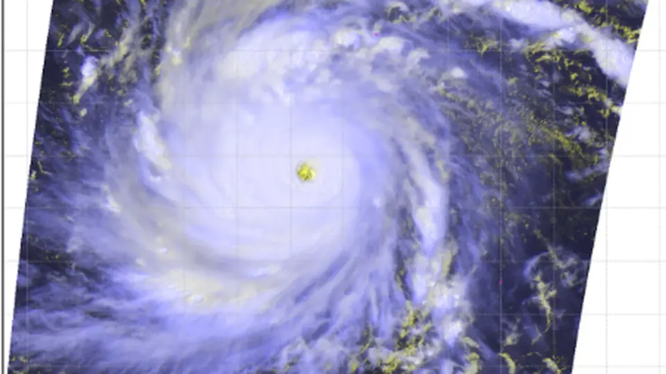
Super Typhoon Dolphin rapidly intensified to Category 5 strength in the Northwest Pacific, becoming the fifth such storm globally in 2026. With peak winds of 165 mph and a central pressure of 910 mb, the storm is currently moving west-northwest. It poses no immediate threat to land but is expected to weaken as it approaches the East China Sea later this week. This rapid intensification aligns with the onset of a strong El Niño event, which typically boosts tropical cyclone intensity in the Pacific.
Key points
- Dolphin peaked at 165 mph (270 km/h) with a 910 mb central pressure on July 30, 2026, after intensifying from a tropical storm in less than 36 hours.
- The storm is the fifth Category 5 tropical cyclone of 2026, putting the year ahead of the 1997 global record pace for such storms.
- Current forecasts indicate Dolphin will maintain super typhoon status through the weekend before weakening to Category 1 or 2 by next Tuesday.
- The storm is expected to pass near the Nansei Islands and eventually enter the East China Sea, where it may pose a storm surge threat to eastern China.
- The rapid intensification is attributed to warm ocean waters (84-86°F) and low wind shear, consistent with the current strong El Niño event.
Background
2026 has already seen four other Category 5 storms: Tropical Cyclone Horacio in February, Super Typhoon Sinlaku in April (which caused $1.5 billion in damage to the Northern Mariana Islands), Super Typhoon Bavi in July (which devastated Rota Island and killed 23 in the Philippines), and Hurricane Genevieve in late July. The 1997 El Niño year holds the all-time record with 12 global Category 5 storms. Climate change is expected to increase the proportion of tropical cyclones reaching Category 4 or 5 strength.
How outlets are covering it
Yale Climate Connections emphasizes the historic nature of Dolphin’s formation near the International Date Line and its alignment with El Niño patterns, noting that 2026 is already ahead of the 1997 record pace. The New York Times provides a tracking perspective, noting that Dolphin eventually reached China as a typhoon by August 10, 2026, and highlights the potential for flash flooding and storm surge impacts in the region. Both sources agree on the storm's rapid intensification and its significance within the broader context of a strong El Niño year.
Why it matters
The rapid intensification of Super Typhoon Dolphin underscores the increasing frequency and intensity of Category 5 tropical cyclones, a trend linked to climate change and El Niño events. As the fifth such storm of 2026, it highlights the potential for more powerful and destructive storms in the Pacific, with significant implications for coastal regions in Asia and the U.S. territories. The storm's path toward the East China Sea also raises concerns for potential storm surge and flooding impacts in eastern China.
What to watch
Dolphin is expected to weaken to Category 1 or 2 by next Tuesday as it moves into cooler waters and encounters dry air. It may pass near the Nansei Islands and eventually enter the East China Sea, where it could pose a storm surge threat to eastern China. Long-range models suggest it will maintain Category 1 or 2 strength as it approaches eastern China.
- Historic Super Typhoon Dolphin hits Category 5 strength in the Northwest Pacific Yale Climate Connections
- Typhoon Dolphin to Move Westward toward Japan’s Ogasawara Islands The Japan News
- Super Typhoon Dolphin barrels towards Asia as it reaches 160 mph winds, equivalent to a Category 5 hurricane Yahoo
- Maps: Tracking Super Typhoon Dolphin The New York Times
- Typhoon Dolphin eases closing in on Wake Island, may still roar to 180 mph by Friday The Guam Daily Post
Want the full story? Read the original reporting
Read on Yale Climate Connections