
Satellite imagery reveals the dynamic floodplain ecology of Congaree National Park
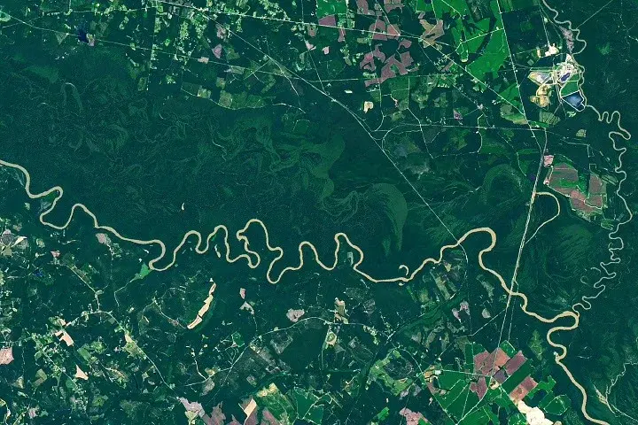
NASA’s Earth Observatory highlights Congaree National Park in South Carolina, where 80% of the park lies within the Congaree River floodplain. Satellite data from Landsat 9 shows how the river’s meandering path creates distinct ecosystems, including oxbow lakes and nutrient-rich wetlands that support some of the largest old-growth bottomland hardwood forests in the U.S.
Key points
- The Operational Land Imager on Landsat 9 captured an image of the Congaree River winding through the park on August 18, 2025, revealing the river's impact on the landscape.
- Congaree National Park is unique among U.S. national parks because 80% of its area is defined by the river's floodplain, supporting one of the largest intact tracts of old-growth bottomland hardwood forests in the country.
- The river's meandering path through flat terrain creates erosion on outer banks and sediment deposition on inner banks, leading to the formation of point bars and U-shaped oxbow lakes like Weston Lake and Bates Old River.
- Frequent flooding, particularly in winter and spring, deposits nutrient-rich silt across the floodplain, nourishing the forests and contributing to the presence of 'champion' trees that have held national size records for species like possumhaw and sweetgum.
- Historically, the park's floodplain forests escaped widespread logging in the 1880s due to difficult access and frequent flooding, leading to conservation efforts that resulted in its designation as a national monument in 1976 and a national park in 2003.
Background
This story provides background on the ecological significance of Congaree National Park, contrasting with recent news about potential land exchanges in other national parks like Yosemite, which have sparked political and conservation debates. While the Yosemite controversy involves privatization and development, Congaree's story emphasizes the preservation of natural floodplain ecosystems and the role of satellite technology in understanding these environments. The archive articles highlight the ongoing tensions between conservation and development in national parks, but Congaree's case focuses on the natural processes that have protected its old-growth forests over time.
Why it matters
Understanding the dynamics of floodplain ecosystems, as seen in Congaree National Park, is crucial for conservation efforts and climate resilience. The park's unique landscape, shaped by the Congaree River, supports biodiversity and provides insights into how natural processes can preserve old-growth forests. Satellite imagery from Landsat 9 offers valuable data for monitoring these ecosystems and informing conservation strategies, highlighting the importance of remote sensing in environmental science.
What to watch
NASA's Earth Observatory continues to provide satellite imagery and data for monitoring national parks and other natural areas. The 'Earth to Sky' program, which connects NASA science with park service rangers, may lead to further collaborations for environmental monitoring and conservation. Additionally, ongoing research into the park's champion trees and floodplain ecosystems could inform broader conservation efforts in similar regions.
Want the full story? Read the original reporting
Read on NASA Science (.gov)