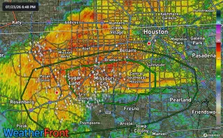
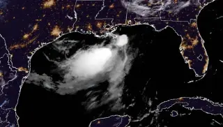
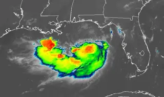
Bertha’s rain bands are drenching the Houston area this evening, triggering a flash flood warning for parts of southwest Harris and Fort Bend counties. Forecasters expect Stage 1 or low-end 2 flooding with some spots near 4 inches, especially west of I-45, as the bands drift north and west. The heaviest downpours should peak in 2–3 hours and taper after about 9–10 PM, with Bertha continuing west-southwest after making landfall east of Houston.
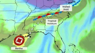
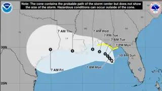
Tropical Storm Bertha is weakening but a broad plume of tropical moisture linked to the system will fuel heavy rain and a multi-day flood threat from the Mid-Atlantic to the Southeast through Thursday and into Friday. The storm’s center is expected to move along the Louisiana and upper Texas coasts before dissipating in Texas, while rain totals in the region reach 2–4 inches (locally 6 inches) along the Texas Gulf Coast; further east, rainfall could be heavy enough to cause flash and urban flooding, with some areas facing a potential month’s worth of rain in a few days. Forecasters have placed a Level 3 of 4 flood risk on parts of the Virginia–North Carolina border Thursday into Friday, and Level 2 of 4 from coastal North Carolina through South Carolina and into northern Georgia and northeast Alabama on Friday, with upgrades possible as forecasts firm up. This flood threat compounds ongoing rainfall concerns from a separate West Virginia flooding event earlier in the week.
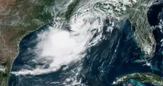
Tropical Storm Bertha made landfall in St. Bernard Parish, Louisiana, with sustained winds around 45 mph and a potential storm surge up to 3 feet; warnings stretched from Alabama to Louisiana as beaches, piers and some roads were closed, while rainfall largely stayed offshore and officials said impacts should be manageable as Bertha weakens inland toward Texas by Friday.
Houston is set for a 100–105°F scorcher today as Tropical Storm Bertha weakens offshore, with scattered evening thunderstorms possible; rain will be focused along the coast over the next few days and heat should ease somewhat over the weekend.
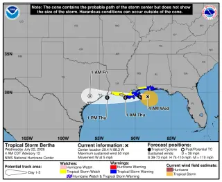
Tropical Storm Bertha weakened but continued a slow westward crawl along the Gulf Coast, with tropical-storm warnings in effect from the Florida Panhandle to Louisiana and watches further west. Maximum winds near 50 mph with higher gusts, potential 2–4 foot storm surge from the mouth of the Mississippi to the LA border, and 1–4 inch rain (locally up to 6 inches) are expected as Bertha nears Texas; forecasters say it will likely weaken and could move inland over Texas in about 48 hours, becoming post-tropical thereafter while the hurricane season outlook remains below average.
New Tropical Storm Bertha strengthened to about 50 mph and is moving toward the northern Gulf Coast, with its center roughly 110 miles south-southwest of Panama City and 170 miles southeast of Mobile as of the 5 a.m. advisory. The NHC forecasts a slow northwest to west-northwest track with some potential strengthening to around 60 mph before wind shear likely limits it, bringing Bertha near or along the northern Gulf Coast over the next several days. A tropical storm warning is in effect from the Alabama/Florida line west to the Louisiana border, with watches extending into parts of Florida and Louisiana, and a storm surge watch for areas from the Alabama/Florida border to the Mississippi River mouth. Impacts could include 1-3 feet of surge along portions of Florida’s coast, 2-4 feet near the Mississippi/Alabama border, and 1-3 feet near Morgan City, plus 2-4 inches of rain (locally up to 6 inches) and dangerous rip currents. The season outlook remains 8-14 named storms with 3-6 hurricanes for 2026.
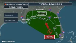
Off Florida, Tropical Depression Two is expected to strengthen into Tropical Storm Bertha later today or tonight, but it is not expected to become a hurricane due to Saharan dust and wind shear. The system could bring heavy rainfall (2-4 inches, up to 6 inches in spots) across Florida’s west coast, Big Bend, and Panhandle, with storm surge and tropical storm watches in effect for parts of the Gulf Coast; an isolated tornado is possible in the Big Bend. Swells will create life-threatening surf and rip currents along the Gulf coast. Forecasters say the system will drift northwest toward the northern Gulf Coast over the next few days, with track uncertainty; residents should monitor updates.
Tropical Depression Two is forecast to strengthen into Tropical Storm Bertha, bringing heavy rain and potential coastal hazards to the Gulf Coast from the Florida Panhandle to Texas. Locally heavy rainfall, coastal flooding, storm surge, rip currents, and a chance of tropical tornadoes are possible, with some areas expected to see up to about 8 inches of rain. The track remains uncertain, but Bertha could approach the Louisiana coast midweek and then move toward Texas, prompting watches and precautionary preparations ahead of the hurricane season.
TD 2 formed in the northeast Gulf and is forecast to drift toward southeast Louisiana as a tropical storm by midweek, bringing heavy rainfall along the Gulf Coast and into the Southeast; winds may reach tropical-storm strength (around 60 mph) with some models hinting at hurricane-strength possibilities, while strong wind shear and dry air likely limit rapid intensification. A tropical storm watch is in effect for the western Florida Panhandle, and moisture could feed heavy rains as far northeast as Virginia and the Carolinas.
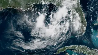
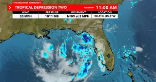
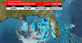
Tropical Depression Two has formed over the northeastern Gulf with a more defined center and 30 mph winds, moving northwest and bringing scattered thunderstorms and gusty winds; meteorologists expect Tropical Storm Bertha to form soon, bringing heavy rainfall to the northern Gulf Coast, with tropical-storm watches in effect from Ochlockonee River to the Florida/Alabama border; the system is not expected to intensify beyond a tropical storm.
Tropical Depression Two has formed in the northeastern Gulf with a defined center and 30 mph winds, moving NW and bringing scattered storms and gusty winds; Bertha is likely to form as a tropical storm as early as tomorrow morning along the Northern Gulf coast, with tropical-storm watches in effect from Ochlockonee River to the Florida/Alabama border.
Tropical Depression Two formed off Florida and is expected to strengthen into Tropical Storm Bertha, with a tropical-storm watch issued from the Ochlockonee River to the Alabama border. The system could bring 1-3 feet of storm surge and 2-4 inches of rain (locally up to 8 inches) along the central/eastern Gulf Coast through Thursday, along with gusty winds and a flash-flood risk for parts of west-central and southwest Florida as it moves and potentially strengthens to around 60 mph. Land interaction adds uncertainty to forecast intensity and track. NOAA still projects a below-normal 2026 hurricane season with 8-14 named storms, 3-6 hurricanes, and 1-3 major hurricanes.
In the season finale of 'The Gilded Age,' George leaves Bertha after feeling manipulated into supporting Gladys' marriage against his instincts, highlighting themes of societal expectations and personal morality during the Gilded Age.