Tag

Hurricane Season

All articles tagged with #hurricane season

NHC Monitors Low-Pressure System Near Cabo Verde With 20% Formation Odds
weather1 day ago

NHC Monitors Low-Pressure System Near Cabo Verde With 20% Formation Odds

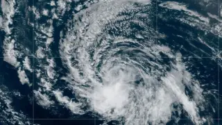
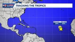
The National Hurricane Center is tracking an area of low pressure in the eastern tropical Atlantic, located a few hundred miles west of the Cabo Verde Islands. The system is producing disorganized showers and thunderstorms but faces a 20% chance of developing into a tropical storm over the next 48 hours and seven days. Strong upper-level winds are expected to hinder further development by midweek, though heavy rainfall is forecast for the islands regardless of whether the system organizes. This monitoring comes shortly after Hurricane Isaias impacted the southeastern United States.

Tropical Storm Rachel Triggers Flood Watches in San Diego and Utah
weather4 days ago

Tropical Storm Rachel Triggers Flood Watches in San Diego and Utah

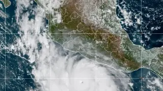
Tropical Storm Rachel is bringing heavy rain and flooding risks to San Diego County and Utah. San Diego faces up to one inch of rain and coastal flooding through Tuesday, while Utah expects multiple inches of precipitation that could alleviate drought but cause flash floods. The storm, which reached Category 2 status in late September, is now moving north-northeast, with remnants interacting with a low-pressure system from Alaska.

Tropical Storm Isaias forms in Gulf, set to strengthen into first 2026 hurricane
weather7 days ago

Tropical Storm Isaias forms in Gulf, set to strengthen into first 2026 hurricane

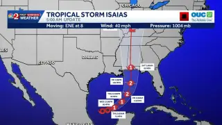
Tropical Storm Isaias formed in the Gulf of Mexico on October 7, 2026, with winds of 40 mph. The National Hurricane Center forecasts rapid strengthening into a hurricane by Thursday, making it the first hurricane of the 2026 Atlantic season. Florida Governor DeSantis declared a state of emergency for 25 counties, while Central Florida faces high rain chances but no direct impact.

Gulf disturbance Invest 92-L likely to form tropical depression, bringing rain to Florida Panhandle
weather8 days ago

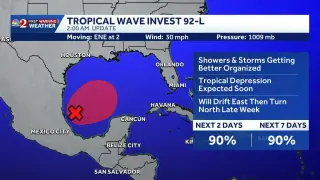
Gulf disturbance Invest 92-L likely to form tropical depression, bringing rain to Florida Panhandle

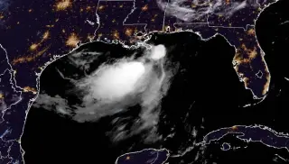
A weather disturbance in the southwestern Gulf of America, designated Invest 92-L, has an 80% to 90% chance of strengthening into a tropical depression within two days. While strong wind shear may limit its intensity, the system is expected to bring heavy rainfall to the Florida Panhandle and central Gulf Coast by the end of the week.

2026 Hurricane Season Split: Record Calm in Atlantic, Hyperactive Pacific Driven by El Niño and Ethiopian Drought
weather15 days ago

2026 Hurricane Season Split: Record Calm in Atlantic, Hyperactive Pacific Driven by El Niño and Ethiopian Drought

The 2026 hurricane season is defined by extreme imbalance: the Atlantic has produced only seven tropical storms and zero hurricanes, while the Pacific has generated 18 named storms and eight hurricanes. This divergence is attributed to a powerful El Niño event and a severe drought in Ethiopia, which disrupted tropical wave formation. The Atlantic’s accumulated cyclone energy is at its lowest since 1925, whereas the Pacific’s activity is far above average, with Hurricane Polo reaching 180 mph winds.

El Niño slams Atlantic hurricane season, setting records for inactivity
weather1 month ago

El Niño slams Atlantic hurricane season, setting records for inactivity

El Niño-driven wind shear is suppressing tropical development in the Atlantic, producing a record-long lull in hurricane activity (about 103 days with no hurricanes as of mid-September) and making 2026 the quietest start-to-date hurricane season since satellite tracking began. The only notable system so far was Tropical Storm Edouard, which stayed below hurricane strength, and forecasters anticipate the back half of the season will remain subdued, though late-season storms can still form near the Gulf and Southeast U.S. In a warming world, even weaker storms can bring significant rainfall, so vigilance remains warranted.

Edouard Fades as Atlantic Activity Grows: Two Waves on Watch
weather1 month ago

Edouard Fades as Atlantic Activity Grows: Two Waves on Watch

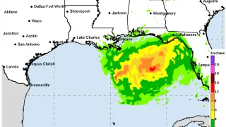
Former Tropical Storm Edouard weakens after Louisiana landfall and is expected to dissipate over Texas, bringing 4–8 inches of rain (with isolated totals up to 12 inches) and gusty winds. The NHC is monitoring two Atlantic tropical waves that could develop as hurricane season approaches its peak, while Florida braces for scattered downpours through Labor Day weekend and Dolly’s remnants may boost moisture into the eastern Gulf. The next named storm to watch is Fay.

Atlantic’s Fourth Named Storm Dolly Forms, U.S. Impacts Not Expected Soon
weather1 month ago

Atlantic’s Fourth Named Storm Dolly Forms, U.S. Impacts Not Expected Soon

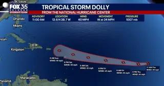
The National Hurricane Center confirms Tropical Storm Dolly formed in the far eastern Atlantic as the fourth named storm of the 2026 season, moving west at about 24 mph with 40 mph winds. It’s not expected to strengthen over the next 48 hours and could weaken to a tropical wave by the weekend. No immediate impacts to the U.S. or Florida are anticipated, though the track remains uncertain while Dolly remains far away.

Tropics Roar to Life: Nine Storms Under Watch Across Atlantic and Pacific
weather1 month ago

Tropics Roar to Life: Nine Storms Under Watch Across Atlantic and Pacific

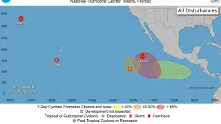
Forecasters are tracking nine storms/potential systems—seven in the Pacific and two in the Atlantic—as hurricane season intensifies. In Hawaii, Moke weakened to a tropical depression offshore, bringing heavy rain and gusts; Lala remains a tropical storm after 12 days; Iselle formed and could briefly reach hurricane strength before dissipating. Four additional Pacific disturbances are being watched, including one with a 70% seven‑day development chance and another with a 30% chance. In the Atlantic, a system southeast of Bermuda has about a 50% chance of forming within 48 hours to seven days, and a tropical wave off Africa may also develop as it moves westward. El Niño is complicating formation in the Atlantic, but tropical development remains possible.

Record-Strong El Niño Could Bring Wetter NC Winter
weather1 month ago

Record-Strong El Niño Could Bring Wetter NC Winter

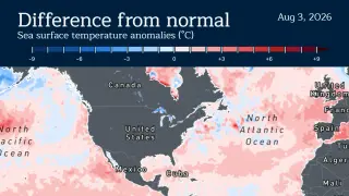
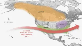
A rapidly strengthening El Niño could become the strongest on record, with NOAA forecasting a very strong event this fall and winter; it could suppress Atlantic hurricane activity by increasing upper-level wind shear, but it is also expected to bring a wetter, potentially snowier winter to North Carolina, possibly easing drought—though exact outcomes are not guaranteed and forecasts will evolve.

Slow Start, Cautious Forecast as 2026 Atlantic Hurricane Season Approaches Peak
weather2 months ago

Slow Start, Cautious Forecast as 2026 Atlantic Hurricane Season Approaches Peak

The 2026 Atlantic hurricane season has started unusually slowly, with NOAA forecasting 8–14 named storms, 3–6 hurricanes, and 1–3 major hurricanes, while CSU keeps its July forecast at nine named storms (four hurricanes, one major). So far two tropical storms—Arthur and Bertha—have formed in the Gulf. Forecasters expect the peak from mid-August to mid-October, but signals point to below-average activity due to a strengthening El Niño and cooler Atlantic waters that raise wind shear in the main development region. A few storms could still form, but this season is shaping up to be among the quietest in years; the Pacific is more active, and the lingering El Niño could influence 2027 as well.

Bertha drifts west along Gulf Coast, prompting tropical-storm warnings
weather2 months ago

Bertha drifts west along Gulf Coast, prompting tropical-storm warnings

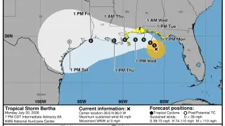
Tropical Storm Bertha weakened but continued a slow westward crawl along the Gulf Coast, with tropical-storm warnings in effect from the Florida Panhandle to Louisiana and watches further west. Maximum winds near 50 mph with higher gusts, potential 2–4 foot storm surge from the mouth of the Mississippi to the LA border, and 1–4 inch rain (locally up to 6 inches) are expected as Bertha nears Texas; forecasters say it will likely weaken and could move inland over Texas in about 48 hours, becoming post-tropical thereafter while the hurricane season outlook remains below average.

Bertha Forms in Gulf, Prompts Flood Watch Along the Coast
weather2 months ago

Bertha Forms in Gulf, Prompts Flood Watch Along the Coast

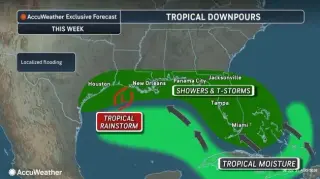
Tropical Storm Bertha formed in the Gulf late July 20, is currently near stationary about 140 miles south of Panama City, Florida, with 40 mph winds, and is forecast to move slowly toward the northern Gulf Coast with potential strengthening through July 21. Tropical-storm watches and a storm surge watch are in effect, as heavy rainfall (2-4 inches, locally up to 8 inches) could lead to flash flooding, especially in urban areas. A westward shift toward Texas Hill Country could raise flash-flood concerns there. Bertha is the season's second named storm, and NOAA expects a below-normal Atlantic season due to El Niño, with 8-14 named storms and 3-6 hurricanes.

Gulf Coast braces for possible tropical storm as depression forms
weather2 months ago

Gulf Coast braces for possible tropical storm as depression forms

A tropical depression formed off Florida along the Gulf Coast with a tropical-storm warning in effect for the Florida Panhandle through Monday night. Forecasters say it could become a tropical storm named Bertha, but strong Saharan dust and wind shear likely prevent hurricane formation; residents from Florida, Alabama, Mississippi and Louisiana should monitor the system for potential high winds and heavy rains.

El Niño Settles In: Quiet Atlantic Season, Wetter South Florida Ahead
weather3 months ago

El Niño Settles In: Quiet Atlantic Season, Wetter South Florida Ahead

NOAA and climate models indicate El Niño will strengthen and likely persist into early 2027, dampening Atlantic tropical development via increased wind shear and forecasting a below-average 2026 hurricane season (CSU projects about 9 named storms, 4 hurricanes). For South Florida, the pattern points to a cooler, wetter, and potentially stormier winter driven by a persistent subtropical jetstream, signaling notable contrasts to the prior winter.