Powerful thunderstorms slammed Toronto and southern Ontario with torrential rain and large hail, sparking flooding, downed trees and widespread power outages across the Greater Toronto Area, with thousands affected and videos showing streets inundated and hail pounding streets in minutes.
Strong thunderstorms are expected to sweep across Michigan on Wednesday, bringing large hail, isolated tornadoes, flash floods, lightning, and 70 mph wind gusts per the National Weather Service. A line of storms is moving southeast across the state, with mid-Michigan and the Thumb at the highest risk and major cities like Lansing, Ann Arbor, Flint, Saginaw and metro Detroit in the path. Storms are anticipated to develop in southeast Michigan around 2 p.m. and persist until midnight. Separately, a heat advisory remains in effect for southern Michigan, with heat indices around 102 degrees.
A line of strong to severe thunderstorms is forecast to move across Central New York, bringing the potential for damaging winds, hail, and flash flooding. Meteorologist Peter Hall outlines timing and impacts and warns residents to stay weather-aware and prepared for possible travel disruptions and power outages.
A line of severe storms swept through the Chicago area with winds over 80 mph, golf- to baseball-sized hail, and flash flooding, causing widespread damage, hundreds of thousands to lose power, and major disruptions to flights and rail/transit; there were reports of tornado touchdowns in Orland Park and Glen Ellyn, though not yet confirmed by the NWS.
Heat index could reach 115°F as severe thunderstorms and tornado warnings sweep across the Chicago area, with damaging winds, large hail, and heavy rain ahead. Warnings cover multiple counties including Will, Cook, Kane, DuPage, Lake and McHenry, and a tornado warning was issued for parts of DuPage, Cook and Will counties and Lake County, Indiana. FAA ground stops were issued at O’Hare and Midway, and a second storm round could develop later in the day as the area remains under an enhanced (level 3 of 5) threat with a weather watch through the afternoon.
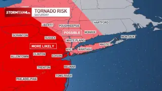
A potent storm system will bring Saturday severe weather to the tri-state, with the National Weather Service rating the risk at level 2 of 5; threats include damaging winds, hail, isolated tornadoes, and flash flooding, with 3–4 inches of rain possible. The greatest risk is in the Poconos, Catskills, and New Jersey, but the threat extends toward NYC, Long Island, and coastal Connecticut. Conditions are expected to improve Sunday, with the World Cup final in New Jersey still on.
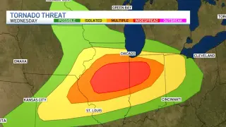
A severe weather outbreak is forecast for Illinois and Indiana on Wednesday, with a potential for long-track tornadoes including EF-3 intensity, especially south of I-80 from about 2 p.m. to 9 p.m.; morning storms (9 a.m.–12 p.m.) could influence the afternoon setup, with the main window likely 4–7 p.m. in central Cook County. South of the warm front could see tennis-ball-sized hail and strong tornadoes, while areas north face damaging straight-line winds; flash flooding is possible, with over 3 inches of rain in some areas. Residents should have alerts, know their safe place, and prepare a weather kit.
A broad storm system sweeping from the central Plains to the Great Lakes and Northeast will bring heavy rain, hail and damaging winds to more than 30 million people. About 13 million are under flood watches in several states, with 6 million at risk for straight‑line winds over 75 mph and possible tornadoes; 19 million face heat advisories with heat indices up to 108°F as the system moves east toward Friday, with reports of power outages in Kansas and dangerous flooding conditions already seen in Indiana.
A Forecast First Alert is in effect Sunday evening through Monday as Minnesota faces multiple rounds of potentially severe storms, with large hail, damaging winds, heavy rain and isolated tornadoes possible. The first round could arrive after 7 p.m. Sunday and continue overnight, followed by a second round Monday afternoon; risk areas include central/southern Minnesota and western Wisconsin, with the Twin Cities metro potentially added depending on Sunday’s activity.
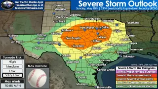
An Enhanced Risk (Level 3/5) of severe storms is forecast Sunday across parts of Texas as a cold front moves south, with large to very large hail (potentially 2 inches or more) and damaging straight‑line winds up to about 70 mph; tornado risk remains low but not zero. The most intense storms are expected in West-Central to North Texas, the Hill Country, and the DFW/Waco areas, with timing mainly Sunday afternoon into Sunday night, then East Texas Sunday evening into overnight. Residents should secure outdoor items, move vehicles under cover, charge devices, and monitor alerts, as travel could be hazardous Sunday evening.
A morning cluster of storms across West-Central and Northwest Texas is shifting north of the Red River, potentially bringing very large hail, damaging winds, and a few tornadoes. The highest risk appears from North Texas into East Texas, with development likely 1–3 PM along a boundary near Texoma, then moving southeast toward the Dallas–Fort Worth area. A cluster could persist tonight, bringing heavy rainfall and localized flooding. The site will offer live Texas storm coverage and an interactive radar to track the storms.
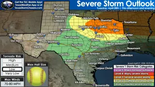
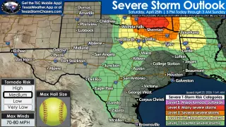
A significant severe weather setup is likely this evening across North Texas, eastern Texoma, and Northeast Texas, with a Level 4 risk near the Red River into Northeast Texas and a Level 3 risk farther north into the DFW area. The main threats are very large hail (4-5 inches), damaging winds (70-80 mph), and a tornado risk, especially near the Red River. Storms could form around 4-5 PM west of the Metroplex and may intensify quickly, with the tornado threat increasing around 6-7 PM and another batch moving southeast from southern Oklahoma into Northeast Texas around 7-9 PM. Most areas may stay dry, but any storms that do form could be dangerous quickly, so stay alert, have multiple warning sources, and seek shelter in a sturdy interior room if warnings are issued. Live coverage and radar tracking are planned by Texas Storm Chasers.
A massive, cross-state tornado and severe weather outbreak rocks the central U.S., unleashing numerous tornado warnings and confirmed tornadoes from the Plains to the Midwest, accompanied by large hail, damaging winds, and widespread power outages as communities brace for continuing storms into the weekend.
A broad storm system sweeps the central U.S. with potential baseball-sized hail and a heightened tornado threat, prompting about 26 million people to be under tornado watches from Wisconsin to Oklahoma. The National Weather Service warns of a 'particularly dangerous situation' for some tornadoes in Illinois and Wisconsin, while damage reports emerge in Minnesota and Wisconsin, Milwaukee experiences flash flooding, and a lightning fatality occurs in Waukesha as Wisconsin’s governor declares a state of emergency.
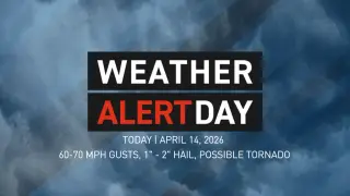
A Weather Alert Day has been issued for West Michigan tonight into early Wednesday due to a developing line of severe storms that could bring damaging winds (60-70 mph), large hail (1-2 inches), and a small tornado risk (about 5%); a flood watch covers nearly all of West Michigan with an additional 2-4 inches of rain possible as storms move quickly from Wisconsin/Illinois toward US-131, with activity peaking around midnight to early morning.