Tag

Satellite Radar

All articles tagged with #satellite radar

Satellite radar reveals 2,600-year-old Egyptian complex buried under Nile mud
archaeology1 hour ago

Satellite radar reveals 2,600-year-old Egyptian complex buried under Nile mud

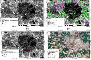
Researchers used satellite radar and electrical resistivity to uncover a massive 2,600-year-old mudbrick complex buried beneath the ancient city of Buto in Egypt's Nile Delta. The structure, dating to the Saite period, rests on an artificial sand foundation designed to stabilize it against the region's unstable clay and high water table. Excavations confirmed the presence of religious artifacts, including a limestone altar and baboon figurines, suggesting the site served a sacred function. This non-invasive approach allows scientists to map deep archaeological layers without the cost and risk of traditional digging.


Radar Satellites Reveal Hidden Winter Movements of Endangered Emperor Penguins
science2 months ago

Radar Satellites Reveal Hidden Winter Movements of Endangered Emperor Penguins

Researchers have successfully used synthetic aperture radar (SAR) from the European Space Agency’s Sentinel-1 satellite to track emperor penguin colonies during the dark Antarctic winter. This method bypasses the limitations of optical imaging, which requires sunlight. By analyzing microwave pulses, scientists identified bright, moving pixel clusters on stable sea ice that correspond to penguin colonies. This allows for year-round monitoring of breeding cycles, including egg-laying and chick-hatching phases, using freely available data from 2017 to 2024. The technique provides critical insights into species behavior during a period previously invisible to standard satellite imagery, aiding conservation efforts for this endangered species.

Satellites map global bridge vulnerabilities
science7 months ago

Satellites map global bridge vulnerabilities

An international study of 744 long-span bridges shows North America and Africa have the riskiest infrastructure, with many spans dating from the 1960s; researchers say space-based radar can detect millimetre-scale deformations, offering a cost-effective, global monitoring method that could flag problems earlier and reduce the number of high-risk bridges—especially as satellites like Nisar enable near-real-time tracking.