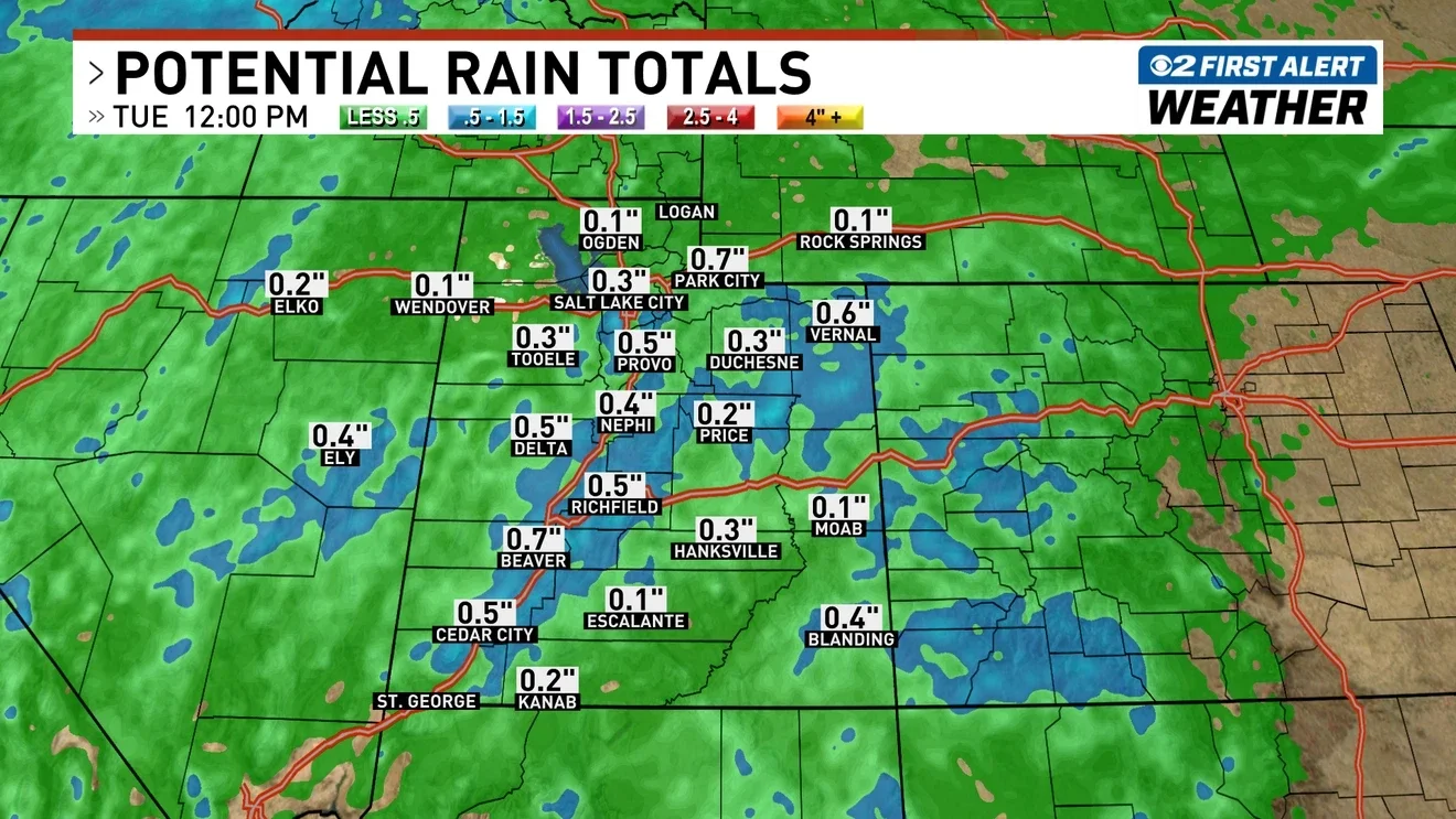
Utah braces for thunderstorms and mountain snow from cold front
A cold front will bring thunderstorms and mountain snow to Utah, with wind advisories in effect statewide as Storm No. 2 approaches; expect windy conditions Sunday ahead of its arrival.
All articles tagged with #wind advisories
A cold front will bring thunderstorms and mountain snow to Utah, with wind advisories in effect statewide as Storm No. 2 approaches; expect windy conditions Sunday ahead of its arrival.
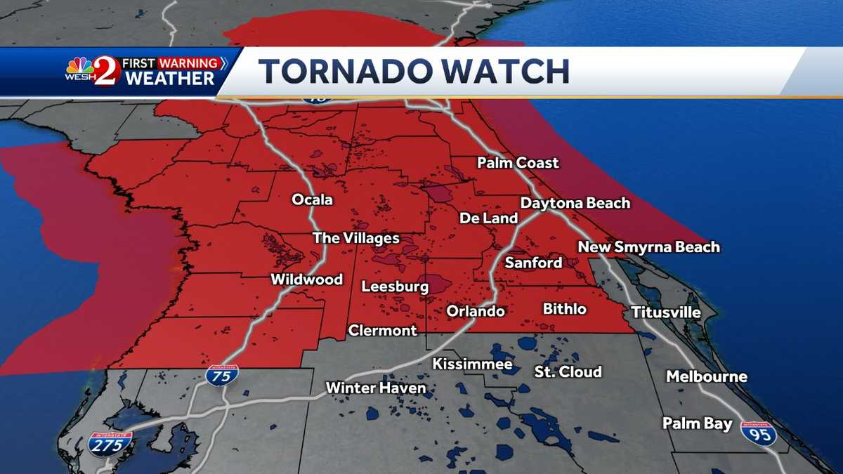
A Tornado Watch has been issued for much of Central Florida as severe weather is expected on Wednesday, with an increased risk of damaging wind gusts, hail, and isolated tornadoes. Wind advisories have been issued for several areas, with gusts ahead of the cold front potentially reaching up to 50 mph. The worst of the weather is expected to hit different areas throughout the day, with a cooldown and sunny weather forecasted for the rest of the week and weekend.

A strong coastal storm is bringing heavy rains and gusty winds to the Northeast's Interstate 95 corridor, with flood watches in place and rainfall totals of 2-5 inches expected. Wind advisories cover over 30 million people, with gusts reaching 40-50 mph and potential power outages. Inland areas of the Northeast are experiencing heavy snowfall, with Winter Storm Warnings in effect and more than 12 inches of snow possible, along with the threat of freezing rain. Chilly air will linger into early next week, with temperatures remaining in the 30s and 40s on Sunday.
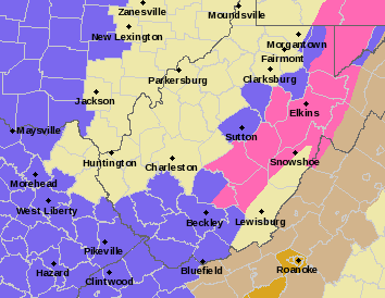
The National Weather Service has issued a winter storm warning for parts of Pocahontas, Randolph, Nicholas, and Webster counties in West Virginia, with the highest elevations expected to receive 5 to 11 inches of snow. Lower elevations could see 2 to 5 inches of snow. Additional counties are under a Winter Weather Advisory. Rain is expected in the area from Charleston to Morgantown, and wind advisories have also been issued with gusts up to 35 mph anticipated.
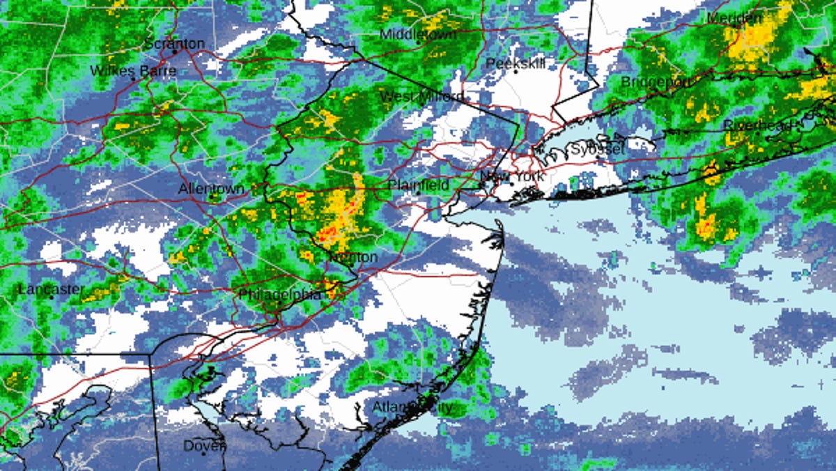
North Jersey is bracing for heavy rain, with as much as 4.5 inches expected Sunday night into Monday morning, causing concerns of flooding and potential disruptions to the Monday commute. A flood watch and wind advisory are in effect, with gusts of up to 45 mph possible. Temperatures will initially be in the mid- to upper-50s before dropping sharply, potentially leading to flurries. Commuters are advised to stay updated on local conditions and avoid driving through flooded roads.
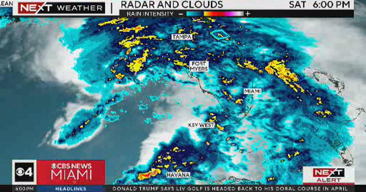
South Florida experienced strong winds and showers, with flood watches and wind advisories in effect. While the initial area of rain was the most intense activity on radar, the showers are expected to weaken and continue into Sunday morning before the front moves through.
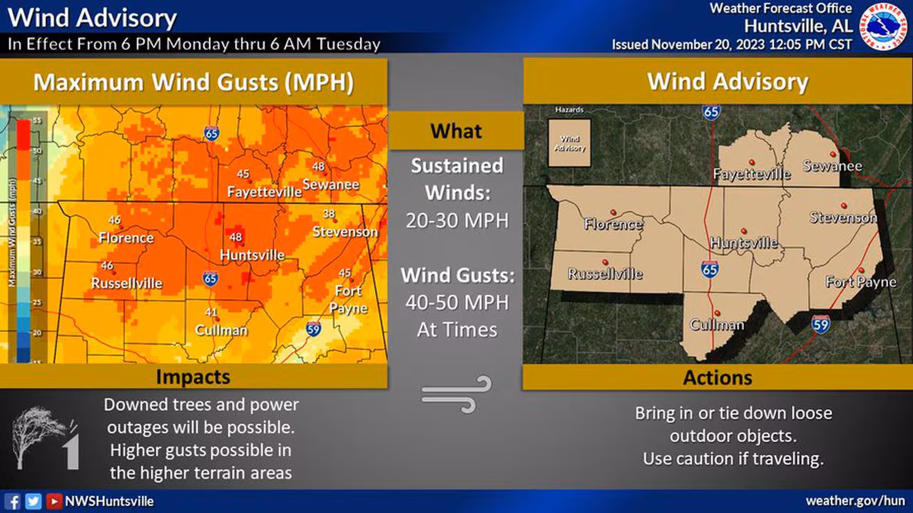
The National Weather Service has issued wind advisories for parts of north and central Alabama, where gusts could reach up to 50 mph. While severe storms are expected, the strong winds could occur separately from the storms. The winds may cause power outages, hazardous driving conditions, and potential damage to outdoor decorations. The advisory will be in effect until early Tuesday morning.
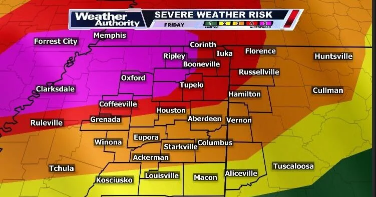
Wind advisories and severe weather watches, warnings, and advisories are in effect for northeast Mississippi and Alabama as a strong frontal system moves through the area, bringing rain and thunderstorms. Some thunderstorms may produce winds over 75-80 mph and strong to violent tornadoes. The front will move out of the area for most of the weekend, but more chances for rain and thunderstorms are expected next week. A tornado watch is currently in effect for Friday evening and overnight, with the highest threat to the west/northwest.
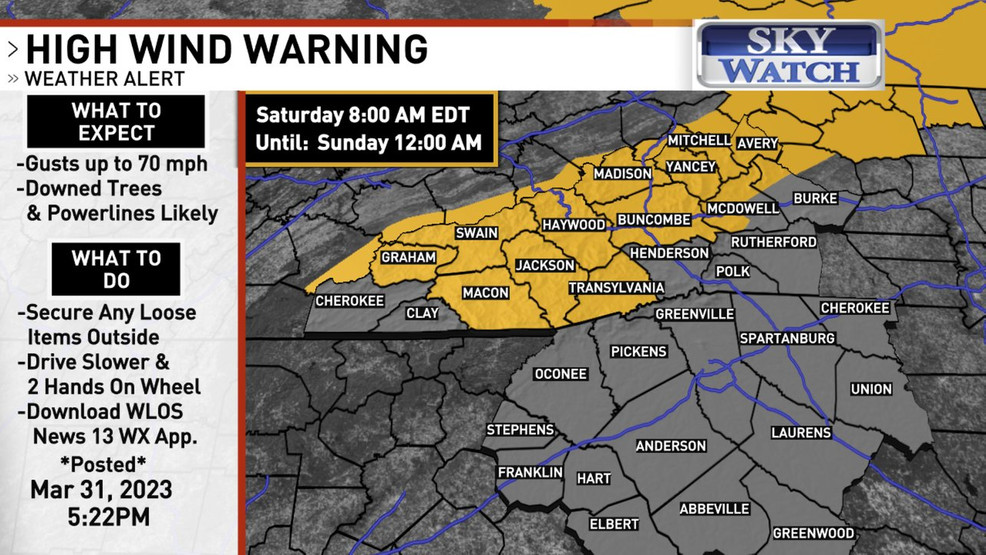
Wind advisories have been issued for Western North Carolina, with gusts of 40 to 60 mph expected over the weekend. Residents are advised to secure outdoor objects and be cautious while driving, as the strong winds may cause hazardous conditions.
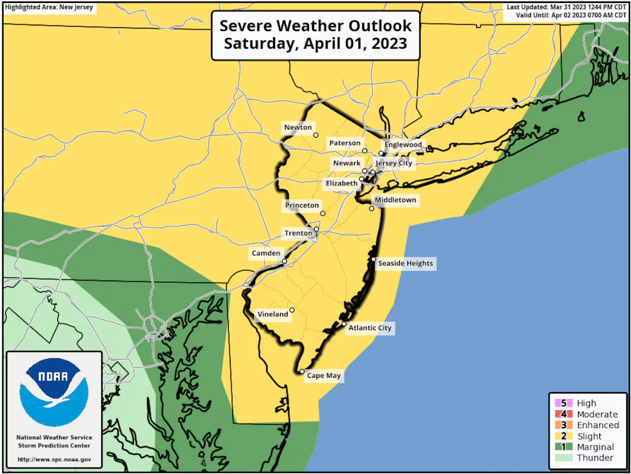
The National Weather Service has expanded the severe thunderstorm threat to include all of New Jersey and eastern Pennsylvania, with damaging winds and the possibility of an isolated tornado. Wind advisories have been issued for most of central and southern New Jersey, with gusts up to 50 mph. The stormy weather is expected to come in two waves, with the second round posing a higher risk of severe thunderstorms due to warming temperatures.