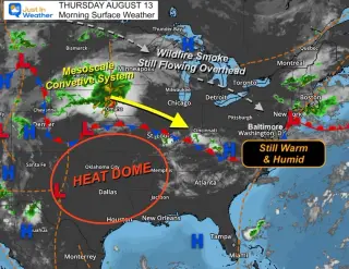
Notre Dame (No. 3) will host Rice in a heat-heavy, humid home opener with storms unlikely. Expect a hot, sticky day on campus and advice to stay hydrated during tailgating as the Irish aim to build on their second-half surge against Wisconsin.
Southern California is under a dangerous humid heatwave with temperatures around 100–108°F and humidity boosting the heat index by about 5–10°F. Relief isn’t expected until Friday as a strong high-pressure ridge and moist onshore flow raise dew points into the 70s. Public health officials warn of elevated heat‑related illness risks, especially for the elderly and medically vulnerable, and urge limiting outdoor activity, seeking air-conditioned spaces, hydrating, and cooling the skin; there could be mountain showers and possible flooding later today, with gradual cooling by week’s end but lingering humidity.
Southern California’s famed dry-heat climate collapsed this summer as record humidity swept in from tropical moisture and unusually warm oceans, a pattern scientists link to climate-change–driven El Niño; the shifting conditions raise concerns about more coastal flooding, erosion and heat risk this winter and in coming years.
The National Weather Service issued an extreme heat warning for San Diego County’s coast, inland valleys and deserts through 8 p.m. Wednesday, with temperatures about 10-15 degrees above average; a heat advisory continues through Thursday for the mountains. Humidity remains high from monsoonal moisture and warm ocean temperatures, keeping conditions muggy even as relief isn’t expected until next weekend. Coastal beaches face a coastal flood advisory and high surf advisory through 11 p.m. Tuesday, with 6-7 foot swells and possible rip currents. Residents are urged to hydrate, shelter indoors, avoid leaving people or pets in cars, and use local cooling centers across the county.
Tropical Storm Marie offshore is pulling humid air into Southern California, triggering a multi-day heat wave with 90s to low-100s temperatures (even 105 inland) and muggy nights; forecasters warn of dangerous rip currents, higher surf, and elevated tides, with heat advisories expanding to multiple counties. Public health officials urge avoiding ocean swimming through midweek and staying hydrated, while residents seek cooling centers.
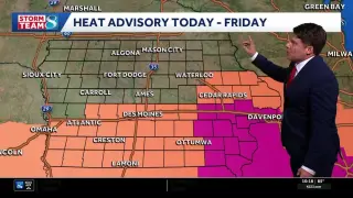
Des Moines and much of Iowa continue a hot, muggy spell through the weekend as a strong ridge keeps heat in place; highs near 95F with dewpoints making it feel hotter, and only spotty morning showers expected from a front near southern Minnesota—no widespread rain or severe storms anticipated, with a gradual cooldown into mid to late next week as the ridge weakens and highs dip to the mid-80s, though humidity remains high.
A hot, humid pattern keeps highs in the mid-90s to around 100°F with heat indices of 100–107°F through Saturday, triggering heat advisories. The Labor Day weekend stays mostly dry with only a slim chance of isolated showers as a weakening front approaches; relief isn’t expected until mid-September when the ridge weakens and showers return.
Southern California’s summer has grown uncomfortably humid, with dew points around 70–75°F in the LA Basin due to remnants of Tropical Storm Iselle, a months-long marine heat wave, El Niño, and climate change. The moist air traps heat and slows sweating, driving record overnight temperatures and making heat feel worse even when daytime highs aren’t extreme.
Southern California braces for its hottest week of the year, driven by record-warm nights and unusually high coastal humidity from warm near-shore oceans and the start of El Niño; daytime highs have been milder, but overnight temperatures are pushing records, increasing heat-related risks and stressing power, pets and sleep, with scientists forecasting the warm-night pattern to persist into fall and at least the first half of winter.
Baltimore remains warm and humid on Aug 13, 2026, with a high around 86°F (feels like 88°) and humidity near 50–60% under mostly sunny skies; dew point around 66°F keeps the air muggy. Saturday is forecast to be nicer with sunshine, while the weekend brings a return of clouds and thunderstorms (roughly 20% Friday, 50% Sunday), with weekend highs in the mid-80s.
New York City braces for another heat wave as a heat advisory is issued through Friday, with high humidity pushing the 'feels like' temperature toward 104F. Cooling centers will reopen, cooling vans will be deployed, and city crews will clear drainage basins in preparation for possible rain and flash floods, while officials urge vulnerable residents to seek air-conditioned spaces and check on neighbors.
Southern California is experiencing unusually humid summer due to a persistent high-pressure pattern, near-record warm coastal ocean waters, and tropical moisture, which have raised dew points to 65–70°F and made nights uncomfortable; scientists warn such humid periods may become more common as oceans warm, though not every year.
New York faces a dangerous heatwave with near-100°F temperatures and high humidity that could feel like 109°F, triggering health warnings and urging residents to secure cooling plans as climate change and a potent El Niño amplify extreme heat.
A Southeast-driven high-pressure system will push an extreme heat event into Chicago from Monday through Wednesday, with temperatures near 100°F and heat indices possibly around 105°F. After Sunday storms, hot, humid air could peak midweek, aided by the Midwest’s “corn sweat” humidity. City officials urge residents to stay indoors, hydrate, and seek cooling centers at city buildings, senior centers, Park District facilities, and other public venues; beaches and pools remain open, and 311 can assist with shelter placements for those in need. Storm activity later in the week could temper the heat, but exact timing remains uncertain.
A heat dome is forecast to fuel a multi-day heat wave across the central U.S. with 90s to near-100s and overnight lows above 80°F, accompanied by high humidity that raises heat indices to about 110°F and threatens heat-related illness, including for Fourth of July visitors in DC and New York. The East could stay hot through the weekend, while Southwest wildfire conditions persist and a late-week jet-stream shift is expected to bring cooler air to the region.