Western New York is cleaning up after Thursday’s severe storms triggered multiple tornado warnings, with confirmed sightings in several counties, widespread power outages, and ongoing National Weather Service surveys as crews work to restore damaged infrastructure.
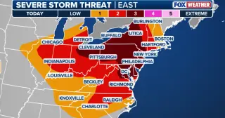
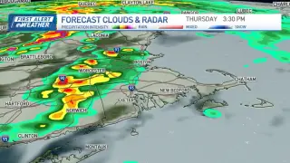
Severe thunderstorms are forecast to sweep the Northeast Thursday evening, placing about 32 million people along the I-95 corridor from Connecticut to Virginia under a flash‑flood risk with heavy downpours (up to 2 inches per hour) and damaging winds. A Tornado Watch covers millions in the DC/Delaware/NJ/PA/VA region as the cold front moves east and stalls, with the potential for urban flooding in NYC, Philadelphia, and Baltimore. The activity could linger into Friday and redevelop over the weekend, threatening travel along I‑95 and prompting continued severe-weather alerts across the Mid-Atlantic and Carolinas.
Severe storms swept through Northwest Indiana, leaving the town of Schererville without power and prompting officials to urge residents to stay put as crews assess downed power lines and overturned semis. I-65 was shut north of I-94 and south of US-20 due to damage, and utilities reported more than 283,000 NIPSCO customers and over 270,000 ComEd customers without electricity as of about 2 p.m. Local Chicago-area suburbs also reported damage and outages from the same storm system.
Chicago is forecast to see a line of severe storms Wednesday (9 a.m.–2 p.m.) with damaging winds, heavy rainfall and frequent lightning, and a brief tornado cannot be ruled out south of the city. The setup follows Tuesday’s storms that caused widespread outages and three Illinois tornadoes; Illinois has logged over 200 tornadoes in 2026. The National Weather Service urges residents to have multiple ways to receive warnings and seek shelter if a warning is issued.
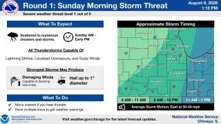
The National Weather Service warns of periodic thunderstorms, some potentially severe, from Sunday through Wednesday across Lake and McHenry counties and the Chicago area. The first round is expected Sunday morning into early afternoon, with a risk of damaging winds and hail up to a quarter-size, plus a localized flash-flood threat as storms train. Additional rounds are anticipated Sunday evening into Monday, with the forecast remaining unsettled through Wednesday. Stay tuned to warnings and take precautions when heavy rain or thunder occurs.
Heavy rain and severe storms trigger flash flood warnings across central and western Massachusetts, causing road closures in towns including Leominster, Fitchburg, Lunenburg, South Hadley, and West Springfield. Route 2 and Merriam Avenue near the Route 2 interchange are down to one lane, and drivers are urged to avoid flooded roads as the weather system moves east; the situation remains developing.
Severe storms swept through Wake County, NC, toppling trees, downing power lines and damaging homes, causing thousands to lose electricity. A 71-year-old man, Mike Ferguson, was killed when a tree fell on his home. Duke Energy reported hundreds of outage events and tens of thousands without power at the peak. Crews worked to clear debris, restore power, and rebuild infrastructure while residents were urged to stay safe and consider trimming trees to reduce future risk.
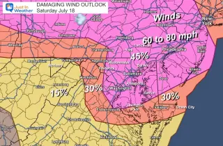
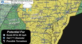
Morning thunderstorms rolled across Central Maryland, helping wash smoke from the air; an Enhanced Severe Storm Risk is forecast for today with damaging winds of 60–80 mph, possible large hail, and a tornado risk, peaking 2–4 PM. The storms are expected to improve air quality, with more rain likely mid‑week.
A multi-state forecast warns of rounds of showers and potentially severe thunderstorms across DC, Maryland and Virginia Saturday, with damaging winds, heavy rain, and isolated tornadoes possible, plus flash flood risks. Heat indices near 105°F and wildfire smoke reduce air quality, though smoke is expected to retreat later in the day. Heat advisories are in effect with improvements anticipated Sunday, when skies should be mostly sunny and temperatures drop into the upper 80s.
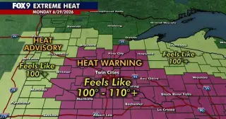
An extreme heat warning spans most of Minnesota (and parts of Wisconsin) from 9 a.m. Monday to midnight Tuesday, with heat index values of 100–110°F due to high humidity; temperatures will reach the 90s with muggy overnight conditions. A few storms are possible Monday evening/night, and several counties are under tornado and severe thunderstorm watches. The heat and storm risk is expected to persist into the midweek with ongoing advisories in western and north-central Minnesota.
A tornado watch is in effect from 10 a.m. to 3 p.m. for parts of western Massachusetts and Vermont as strong to severe thunderstorms move through New England, capable of damaging winds, small hail and heavy rainfall; a brief isolated tornado cannot be ruled out. If enough sunshine breaks through, the threat could rise across central/eastern Massachusetts and southern New Hampshire. Expect gusty winds around 40 mph, with flash flooding possible in parts of New Hampshire and Maine; Vermont is under wind advisories with gusts up to 50 mph. Showers and storms should diminish after dinner, with weekend highs in the 70s to 80s.
Baltimore is baking under hot, humid conditions today with temperatures pushing into the 90s; forecasters warn of a risk of severe thunderstorms tonight, followed by cooler, less humid air moving in later this week as a pattern shift brings relief.
Unseasonably hot conditions grip much of the U.S. this weekend, with temperatures reaching up to 108°F in several cities and about 26 million people facing extreme heat across the West, Plains and Southeast. The West Coast is also bracing for 80s to 100+ degree days with heat alerts in areas like Bakersfield, Redding, Portland and Seattle. Separately, severe thunderstorms and flash floods threaten 22 million from Texas to Kentucky, including cities such as Kansas City, Tulsa, Wichita and Springfield, MO, with the potential for nocturnal tornadoes and damaging winds. By Sunday, showers could push into the mid-Atlantic and Ohio Valley, potentially affecting as many as 54 million in NYC, Philadelphia, Baltimore and Washington, D.C. Some of the warming may be linked to El Niño.”,
A line of severe thunderstorms swept across Minnesota overnight with wind gusts exceeding 80 mph, downing trees and leaving more than 70,000 customers without power as crews raced to restore service; officials warned of more severe weather later Wednesday as hot, humid air meets a cold front.
Gov. Greg Abbott directed the Texas Division of Emergency Management to activate state emergency resources as a large storm system threatens most of Texas through Monday, with potential 75 mph winds, large hail and tornado risk; search-and-rescue boats, aviation and marine support, debris-clearing crews, EMS task forces and utility monitors have been deployed to assist local officials, while residents are urged to monitor forecasts, avoid flooded roads and prepare emergency kits.