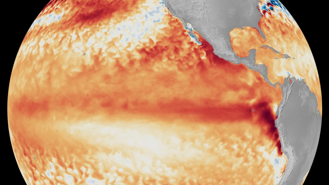
The National Weather Service is collecting snowfall data from the March 15–16 blizzard in southeast Wisconsin and publishing an ongoing, location-based snowfall tally—totals may be adjusted later—as FOX6 provides weather tools and updates.
Delta canceled Midwest flights, including at its Minneapolis-St. Paul hub, ahead of a winter storm and urged customers to rebook at no cost via the Delta app or delta.com; the airline will automatically rebook to the next best itinerary to minimize disruption while prioritizing safety.
A late-season winter storm will sweep from the northern Plains to the Great Lakes this weekend into Monday, bringing widespread heavy snow (roughly 10–30 inches, with some spots near 40) and a corridor of severe thunderstorms that could affect about 11 cities.
A sprawling late-winter storm is set to hit the northern Plains, Midwest and Great Lakes, bringing heavy snow (likely feet), strong winds and reduced visibility, triggering travel disruptions and potential power outages as it edges into southeastern Canada, with thunderstorms and tornado risks in parts of the Plains.
An incoming winter system for Thursday night into Friday will bring rain, then a wintry mix and snow across much of New England. The amount and type depend on how quickly cold air moves in and how heavy the precipitation is, with sleet possible near Worcester/Boston and notable travel impacts in eastern and northern Massachusetts. Snow totals may reach 2–4 inches in southern Vermont/NH and the Merrimack Valley; 1–2 inches in the Boston metro if changeover to snow is late, with less snow further south. Freezing rain could occur where surface temps hover near 32 F, while Southeastern Massachusetts faces 1–1.5 inches of rain on top of existing snow, risking localized flooding. Friday morning commutes look slick, and lingering freezing fog or drizzle could extend slick conditions. After the system, weekend looks calmer and milder with 40s–50s and a possible warm-up into the 60s next week.
A two-part winter system moves overnight into Tuesday, bringing freezing rain and a risk of a light ice glaze (up to about 1/4 inch inland) that could slick untreated surfaces and affect the Tuesday morning commute. The Winter Weather Advisory covers counties west and north of Baltimore and Washington, with possible school disruptions depending on conditions. The freezing rain is expected 4–7 a.m. before temperatures rise and rain resumes later in the day; Monday’s snow has largely melted, though pockets of 1–3 inches were reported in some areas.
Winter weather is returning to the Midwest and Northeast this weekend as a fast-moving system moves east, bringing snow and travel delays; meanwhile parts of the West are experiencing record warmth. Massachusetts endured significant power outages from the prior nor’easter, and icy conditions are possible from Missouri into northern New England, with snow likely in the Midwest moving toward D.C. and New York City by Monday. Next week could bring more storms and heavy rain to the Plains and Mississippi Valley, with potential flooding.
A fresh wave of light snow swept the Northeast after a historic storm left huge piles of snow from Maryland to Maine, prompting salt deployments and thousands of shovelers in cities like New York while warning of patchy ice on roads; the region also faced ongoing accessibility challenges for people with disabilities, dozens of power outages, and flight disruptions as some schools and services returned to normal amid continued snow-clearing efforts and dumping grounds for snow.
Two chances for light snowfall in the Boston area: a Wednesday morning event expected to last about 4–6 hours with a coating to 1 inch east of Route 495 and 1–2 inches west, with possible rain mixing in along the South Coast; most accumulation should melt by afternoon as sun returns; a small, uncertain chance of a Thursday night flurry if a southern storm brushes by; weekend forecast calls for near 50°F.
A historic Northeast blizzard dumped up to three feet of snow, with Warwick, Rhode Island reporting 36.2 inches, prompting emergency declarations in seven states and causing thousands of flight cancellations, road closures, and widespread transit disruptions for more than 40 million residents.
A major East Coast winter storm blankets the DC region with heavy, wet snow that falls unevenly—heaviest north and west of the Beltway and into Southern Maryland—knocking out power and gusting winds; the Capital Weather Gang explains how forecasters crafted the forecast, where predictions missed, and where they were on target.
A developing nor'easter off the Mid-Atlantic coast is expected to rapidly intensify Sunday night into Monday, with about 35 million people under blizzard warnings and roughly 65 million under weather alerts as the storm tracks up the Northeast. The worst conditions are anticipated overnight Sunday into Monday, with forecasts of heavy snow—potentially a foot or more in parts of the Delaware-to-SE Massachusetts corridor—alongside travel disruptions and school closures across the region.
A powerful nor'easter will hit the Mid-Atlantic and Northeast, bringing more than a foot of snow, blizzard conditions, and coastal flooding Sunday into Monday, threatening travel, road closures, and flight and school disruptions for about 80 million people from Delaware to Massachusetts.
A winter storm is bringing heavy snow to eastern Iowa Thursday evening into Friday morning, with rain turning to snow after 1 p.m. and potential accumulations of 6-8+ inches near the Highway 20 corridor. Winter Storm Warnings and Advisories are in effect from 6 p.m. Thursday to 6 a.m. Friday, bringing gusty winds and slick, snow-covered roads as crews work to clear them.
Forecasters are monitoring the potential formation of a bomb cyclone near the Delmarva Peninsula between Sunday and Monday. If it develops, a broad swath of the Mid-Atlantic and Northeast, from Washington, D.C. to Boston, could see accumulating snow and strong winds, leading to slippery roads and travel disruptions.